火山研究情報 トップへ
福徳岡ノ場火山の噴火情報 トップへ
沖縄本島に漂着した軽石の状況(第2報)
Status and impacts of pumice rafts around Okinawa Island(Part 2)
活断層・火山研究部門
開設:2021年11月9日
10月28-30日にかけて沖縄本島で再び漂着軽石の調査を行いました。
行き返りの飛行機からも沖縄本島周辺に多数の軽石(軽石いかだ)が観察できました(写真1)。調査の結果、隣接した地域でも、海岸の地形や風・海流などが組み合わさって、多くの軽石が漂着している海岸とそうでない場所に分かれることを確認しました(写真2)。さらに、自然の海岸などについた軽石は,潮の満ち引きや風・海流などの変化で、漂着する量が毎日大きく変化しますが、港湾内に一旦滞留した軽石は、なかなか出ていかず比較的変化が少ないことがわかりました。港湾に滞留している軽石の厚さは、約10~20cmほどでした。この値は港湾内などに浮遊する軽石の体積を計算する際に目安になります。
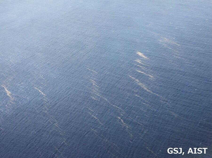
写真1 航空機から望む沖縄本島南部の軽石いかだ(10月28日)。
ベージュ色の筋が軽石いかだ。沖縄本島の周辺海上には多数の軽石いかだの漂流が認められました。
Photo 1 Pumice rafts (beige streaks) in the southern part of the main island of Okinawa seen from a plane (October 28). A large number of pumice rafts were observed drifting in the sea around the main island of Okinawa.
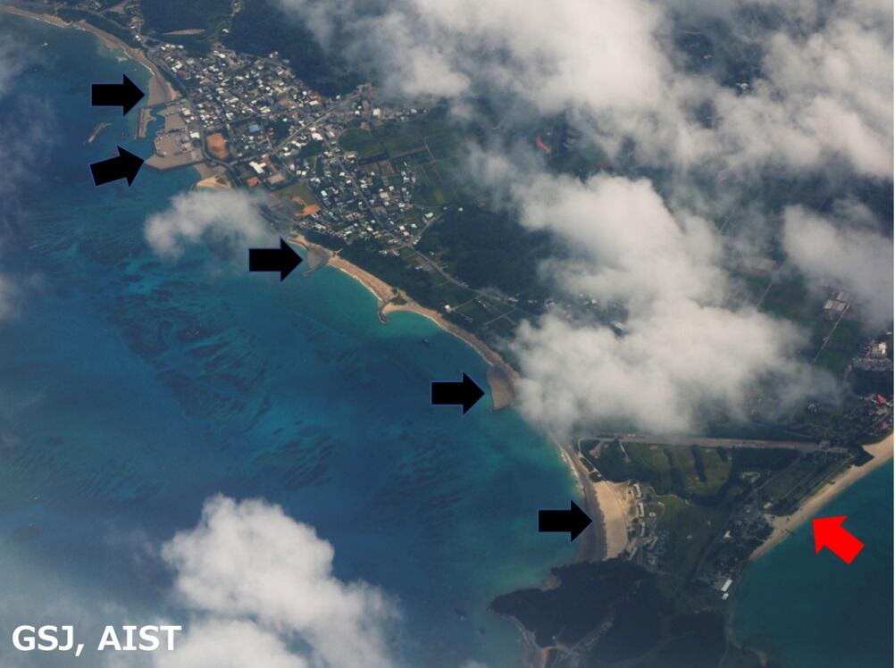
写真2 航空機から見た国頭村辺土名漁港(左上)から奥間ビーチ(右下)の海岸(10月28日)。
隣接した地域でも、海岸に軽石が漂着している量は大きく異なります。黒矢印で示した海岸には多量の軽石が漂着しており灰色になっていますが、赤矢印の海岸にはそれほど多く漂着していません。海岸の地形や風・海流などが組み合わさって、多くの軽石が漂着している海岸とそうでない場所に分かれます。
Photo 2 The western coastline of Kunigami Village, from Hentona fishing port (upper left) to Okuma Beach (lower right) as seen from a plane (October 28). Even in adjacent areas, the amount of pumice that has been washed ashore varies greatly. Black arrows indicate locations on the coastline that are distinctly gray because large amounts of pumice have been washed ashore, and the red arrow indicates a beach where no pumice has been deposited. The combination of coastal topography, winds, and ocean currents divides the coast into such areas where pumice is deposited or not.
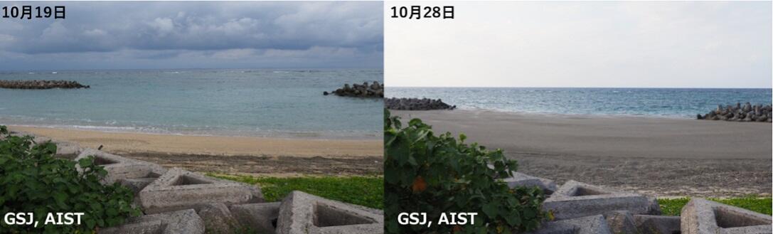
写真3 10月19日と10月28日の大宜味村大兼久の海岸。
10月19日より28日のほうが、漂着した軽石の量が増えています。しかし、地元の人への聞き込みから、自然の海岸などに漂着する軽石の量は、潮の満ち引きや風・海流などで、毎日大きく変化するそうです。
Photo 3 Comparison of the coast of Oganeku, Ogimi Village on October 19 and 28. The amount of pumice washed ashore increased markedly between October 19 and 28. According to interviews with the locals, however, the amount of pumice washed ashore on the natural coast changes greatly every day due to the ebb and flow of the tide, and variable wind conditions and ocean currents.
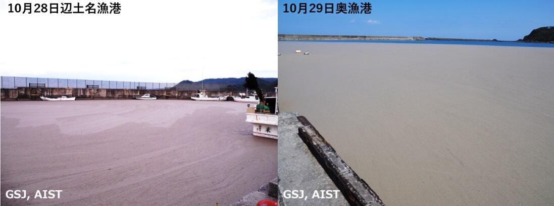
写真4 沖縄県国頭村辺土名漁港(左)と国頭村奥漁港(右)内に滞留する軽石。
自然の海岸と異なり、港湾内に一旦滞留した軽石はなかなか出ていきません。港湾内に浮遊している軽石の厚さを計測したところ、約10~20cmでした。
Photo 4 Pumice trapped within the Hentona fishing port (left) and the Oku fishing port (right) in Kunigami Village. Unlike along the natural coast, pumice that drifts into harbours becomes trapped and does not move back easily into the open sea despite changes to ocean and wind conditions. The thickness of the floating layer of pumice in the harbour was measured and found to be about 10 to 20 cm.
お問い合わせ
災害と緊急調査
- 地震・津波研究情報
- 火山研究情報
- 土砂災害研究情報
- その他の地質災害研究情報