






Bulletin of the Geological Survey of Japan Top Page
Bulletin of the Geological Survey of Japan Vol.77 No.3/4 (2026)
Special issue on marine geology in the region northwest of Kyushu Island: result of marine geological mapping survey cruises in 2024
Cover photograph | Table of Contents | Abstract
Cover Figure
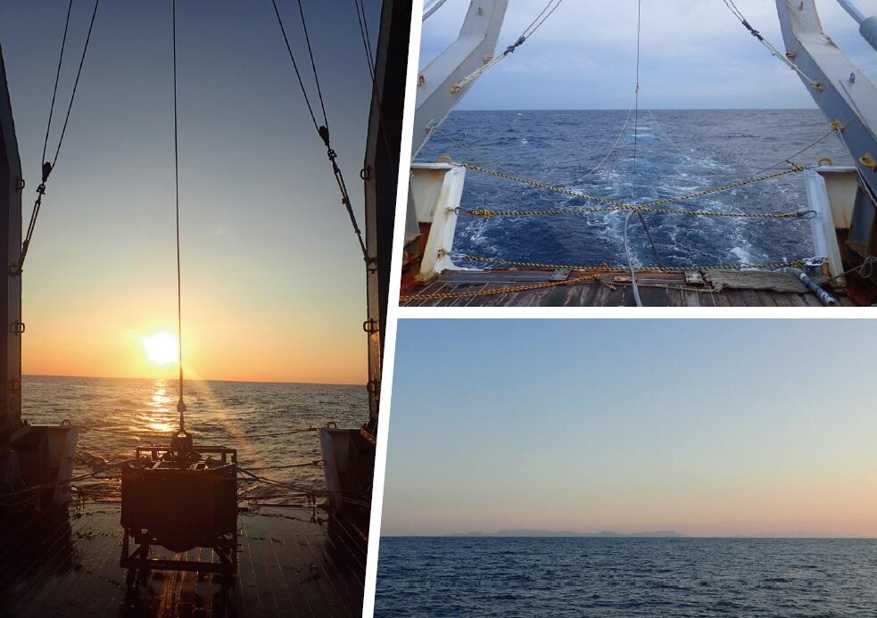
Marine geological survey in the region northwest of Kyushu Island during Fiscal Year 2024
The Geological Survey of Japan (GSJ) has published the 1:200,000 Marine Geology Map Series for Japan since the 1970s. In this special issue, we report the results of seismic reflection profiling surveys, bathymetry surveys, magnetic anomaly surveys, and marine sediment surveys conducted in the region northwest of Kyushu Island during Fiscal Year 2024 as the northernmost area of the Okinawa Trough Project.
Left: Photograph of the grab sampler on the vessel deck at sunset during the marine sediment survey.
Top right: View from the vessel stern with the air gun, streamer cable, and magnetometer being towed behind the vessel.
Clusters of white bubbles on the sea surface are produced by the air gun pulses.
Bottom right: Photograph of the Koshikishima Islands at sunset, as seen from the Gotonada Sea.
(Photograph and Caption by INOUE Takahiko)
Table of Contents
All the pages PDF : 77_03_full.pdf [85.2MB]
| Title | Author | |
|---|---|---|
| Preface | ||
| Special issue on marine geology in the region northwest of Kyushu Island: result of marine geological mapping survey cruises in Fiscal Year 2024 | INOUE Takahiko, ITAKI Takuya, AMANO Atsuko and MISAWA Ayanori (p.71-75) | 77_03_01.pdf [1.3MB] |
| Report | ||
| Preliminary bathymetry determined during cruises GS24 and GB24 offshore from northwestern Kyushu, Japan | KOGE Hiroaki, SATO Taichi and FURUYAMA Seishiro (p.77-84) | 77_03_02.pdf [7.8MB] |
| Preliminary results of a magnetic anomaly survey off Northwest Kyushu during cruises GS24 and GB24 | SATO Taichi and KOGE Hiroaki (p.85-90) | 77_03_03.pdf [2.7MB] |
| Preliminary report on geological structures in and around the Amakusanada Sea, SW Japan, based on seismic surveys | ARIMOTO Jun, ISHINO Saki and INOUE Takahiko (p.91-115) | 77_03_04.pdf [52.8MB] |
| Shallow subbottom structure around the Gotonada and Amakusanada seas based on a high-resolution subbottom profiler survey during cruise GS24 | MISAWA Ayanori, FURUYAMA Seishiro, KOGE Hiroaki and ARIMOTO Jun (p.117-128) | 77_03_05.pdf [9.5MB] |
| Primary report on marine sediment sampling in the northeastern East China Sea and north Danjo Basin | SEIKE Koji, IIZUKA Mutsumi, ITAKI Takuya, MIMURA Kazuhide, SUZUKI Yoshiaki, YOSHIOKA Jumpei, KOBAYASHI Genki, ARIMOTO Jun, KUWANO Daisuke and YAMASAKI Makoto (p.129-144) | 77_03_06.pdf [4MB] |
| Water mass structure off the western coast of Kyushu based on CTD observations during cruise GB24 | MIMURA Kazuhide, SEIKE Koji, ITAKI Takuya, IIZUKA Mutsumi, SUZUKI Yoshiaki and SUZUKI Atsushi (p.145-152) | 77_03_07.pdf [2.7MB] |
| Seafloor rock samples collected offshore western Kyushu during Cruise GB24 and calcareous nannofossil ages of sedimentary rocks | ISHINO Saki, ARIMOTO Jun, UTSUNOMIYA Masayuki and SEIKE Koji (p.153-164) | 77_03_08.pdf [5.5MB] |
| Chemical composition of marine surface sediments in the area offshore from northwestern Kyushu, Japan (Cruise GB24) | KUBOTA Ran, TACHIBANA Yoshiko, SEIKE Koji, ITAKI Takuya, SUZUKI Yoshiaki, IIZUKA Mutsumi and MIMURA Kazuhide (p.165-180) | 77_03_09.pdf [2.4MB] |
| Preliminary report of modern ostracod assemblages off the northwestern Koshikishima Islands, Kagoshima Prefecture, southwest Japan | SASAKI Satoshi, SUZUKI Yuto, NAKANO Taiga and SEIKE Koji (p.181-187) | 77_03_10.pdf [1.5MB] |
| Diversity of azooxanthellate scleractinian corals collected off western Kyushu during cruise GB24 | TOKUDA Yuki, SENTOKU Asuka, SHIROMIZU Nanako and SEIKE Koji (p.189-193) | 77_03_11.pdf [2MB] |
Abstract
Preliminary bathymetry determined during cruises GS24 and GB24 offshore from northwestern Kyushu, Japan
KOGE Hiroaki, SATO Taichi and FURUYAMA Seishiro
Seafloor mapping surveys were conducted offshore from northwestern Kyushu, Japan, using a multibeam echo sounder (MBES) to support the compilation of marine geological maps. This report contains the results of four cruises, including GS24 and GB24 conducted in 2024, and presents the data acquisition and processing methods, the processed bathymetry, and preliminary interpretations of the seafloor topography.
Preliminary results of a magnetic anomaly survey off Northwest Kyushu during cruises GS24 and GB24
SATO Taichi and KOGE Hiroaki
Geomagnetic surveys were conducted to construct marine geophysical maps of the area off Northwest Kyushu. A total magnetic anomaly map was created based on observations of the total magnetic field. The survey area is characterized by a complex distribution of magnetic anomalies ranging from short to long wavelengths. Short-wavelength magnetic anomalies were identified in the offshore region extending from east of the Goto Islands to southeast of the islands. These anomalies are likely to reflect igneous rocks in the shallow subseafloor, as also observed on nearby islands. The magnetic anomaly field is spatially distinct from the positive magnetic anomalies associated with the Taiwan–Sinzi belt; consequently, the interpretation of magmatic activity in this area requires further integrated investigation. Belts of positive and negative magnetic anomalies, as well as multiple discrete anomalies, extend across Nagasaki Peninsula, the Nagasaki Spur, and the northern Danjo Basin, which are presumably composed of metamorphic rocks. Several dipole-type magnetic anomalies were detected in the Amakusanada Sea.
Preliminary report on geological structures in and around the Amakusanada Sea, SW Japan, based on seismic surveys
ARIMOTO Jun, ISHINO Saki and INOUE Takahiko
We conducted a multi-channel seismic survey using a GI gun, continuing the work from fiscal year 2023, as part of 1:200,000-scale seafloor geological mapping of the northernmost part of the Okinawa Trough, west of Kyushu in SW Japan. In this paper, we present a preliminary interpretation of the geological structures observed in 2D cross-sections through the area, including the northernmost part of the Okinawa Trough. We identified acoustic basement and overlying sedimentary units throughout the survey area. Acoustic basement, which corresponds to Miocene or Paleogene sedimentary rocks, or older basement rocks, occurs at shallow depths in coastal regions and around submarine topographic highs. Beneath the peripheral seafloor slope of the Okinawa Trough, acoustic basement is accompanied by steepened slopes toward the trough. The sedimentary units interpreted from our seismic data generally correspond to Pliocene–Pleistocene basin-fill strata. Stacked clinoform deposits are widespread in the shelf region. The shelf region in the East China Sea contains erosional landforms on the seafloor and buried channel structures. Sedimentary units beneath the area extending from the slope to the basin floor are characterized by well-defined continuous reflectors and increase in thickness below the lower slope, suggesting continuous subsidence toward the trough region. The Nagasaki Spur and its extension, which separate the Gotonada and Amakusanada sedimentary basins, comprise acoustic basement highs as well as uplifted and highly deformed sedimentary strata. Folds occur in the Amakusanada sedimentary basin and the peripheral region of the Nagasaki Spur. High-angle normal faults are common in the survey area, and most of these originated as strike-slip faults in transtensional stress regime. Many of the faults and folds are likely to have formed during the Pliocene–Pleistocene.
Shallow subbottom structure around the Gotonada and Amakusanada seas based on a high-resolution subbottom profiler survey during cruise GS24
MISAWA Ayanori, FURUYAMA Seishiro, KOGE Hiroaki and ARIMOTO Jun
A high-resolution subbottom profiler (SBP) survey was conducted in the Gotonada and Amakusanada seas during cruise GS24 from September to October 2024, using the R/V Shinyo Maru (Tokyo University of Marine Science and Technology) to obtain geological information on the shallow subbottom structure in this region. This paper summarizes the shallow subbottom structure as revealed by the SBP surveys. An unconformity surface was identified near land in the continental shelf area. This unconformity surface is uneven, indicating the effects of erosion on the underlying sedimentary sequence. We clarified the geological structure of the sedimentary sequence along the slopes and floor of the Goto Canyon. Furthermore, a high-angle fault reaches the seafloor at the southeastern foot of the Nagasaki Spur and its extension, suggesting that the fault is active.
Primary report on marine sediment sampling in the northeastern East China Sea and north Danjo Basin
SEIKE Koji, IIZUKA Mutsumi, ITAKI Takuya, MIMURA Kazuhide, SUZUKI Yoshiaki, YOSHIOKA Jumpei, KOBAYASHI Genki, ARIMOTO Jun, KUWANO Daisuke and YAMASAKI Makoto
As part of the Marine Geological Map Project undertaken by the Geological Survey of Japan, a geological survey (cruise GB24) was conducted in the northeastern East China Sea and northern Danjo Basin. Although much of the survey area has water depths of <200 m, deeper areas also exist, such as Goto Canyon (400–600 m) in the southwestern part of the Goto Islands and the Danjo Basin (maximum water depth: ~800 m) in the southern part of the Goto Islands. Samples of seafloor sediment were collected at 141 sites using a Kinoshita grab (K-grab) sediment sampler (139 sites), a gravity-corer (1 site), and a rock corer (1 site). Here we report the characteristics of the marine seafloor sediments, focusing on the samples collected using the K-grab sampler. Fine- to medium-grained sediments with a low mud content occur around the Goto Islands and in the western part of the Amakusa Islands. Muddy sediments are dominant in the Danjo Basin, although fine-grained sand to gravel-sized sediments with low mud contents occur at topographically higher sites. The seafloor sediments contain bioclasts such as molluscan shells and coral remains, including fossilized shells. This report also contains preliminary information on the polychaete assemblages, calcareous nannoplankton, and major planktic and benthic foraminifera in the seafloor sediments.
Water mass structure off the western coast of Kyushu based on CTD observations during cruise GB24
MIMURA Kazuhide, SEIKE Koji, ITAKI Takuya, IIZUKA Mutsumi, SUZUKI Yoshiaki and SUZUKI Atsushi
During cruise GB24 conducted from October to November 2024, physical properties of seawater were observed at 108 sites off the western coast of Kyushu by CTD profiler. The threedimensional distributions of temperature, salinity, and dissolved oxygen indicate that surface seawater in the survey area was mainly affected by the Tsushima Warm Current, which originates from the Kuroshio Current. In deeper layers, the contributions of Subtropical Mode Water and North Pacific Intermediate Water were detected. At some sites located close to the Yatsushiro Sea and the Ariake Sea, we observed surface waters with high temperatures and low salinity, as well as bottom waters with high temperatures and low dissolved oxygen concentrations.
Seafloor rock samples collected offshore western Kyushu during Cruise GB24 and calcareous nannofossil ages of sedimentary rocks
ISHINO Saki, ARIMOTO Jun, UTSUNOMIYA Masayuki and SEIKE Koji
Seafloor sediment samples were collected from around the Goto Islands off western Kyushu and in the northern part of the Danjo Basin during Cruise GB24. Rock samples were obtained from 17 K-grab sampling sites. Most of these sites are widely distributed along the northern slope of the Danjo Basin. In addition, at sites where seismic profiles indicate the presence of outcrops, rock sampling was attempted using a rock corer (Site GB24-RC02) and a K-grab sampler (Sites GC15-KG and GC16-KG). Although no samples were recovered using the rock corer, various samples were collected using the K-grab, including granitic, metamorphic, and sedimentary rocks. Among the sedimentary rocks obtained during the cruise, 14 samples were examined for calcareous nannofossil assemblages. These analyses indicate that some of the samples are correlated to the Middle and Upper Pleistocene.
Chemical composition of marine surface sediments in the area offshore from northwestern Kyushu, Japan (Cruise GB24)
KUBOTA Ran, TACHIBANA Yoshiko, SEIKE Koji, ITAKI Takuya, SUZUKI Yoshiaki, IIZUKA Mutsumi and MIMURA Kazuhide
This study reports the concentrations of 23 elements determined for 130 marine surfacesediment samples collected from the area offshore from northwestern Kyushu, and discusses their geochemical characteristics and spatial distribution. Among the elements analyzed in this study, CaO, T-Fe2O3, and Al2O3 exhibit relatively high concentrations, while trace elements such as Sr and Ba are relatively enriched. With decreasing grain size, CaO and Sr concentrations decrease, whereas Al2O3 and K2O tend to increase. Positive correlations are observed between CaO and Sr, and between K2O and Rb, across all samples, suggesting that Ca and Sr are associated primarily with biogenic debris particles, whereas Al, K, and Rb reflect contributions from felsic clastic materials. Based on these elemental characteristics, higher inputs of biogenic particles are inferred for areas around the Goto Canyon and the area west of the Goto Islands, whereas higher inputs of terrigenous clastic material are inferred for the Amakusanada Sea. The deeper part of the Danjo Basin contains high concentrations of elements such as Ni, Cu, Zn, and Pb, which are commonly enriched in sulfides. In contrast, TiO2 concentrations are generally low throughout the study area, suggesting a limited influence of mafic volcanic materials.
Preliminary report of modern ostracod assemblages off the northwestern Koshikishima Islands, Kagoshima Prefecture, southwest Japan
SASAKI Satoshi, SUZUKI Yuto, NAKANO Taiga and SEIKE Koji
This study investigated the distribution of modern ostracods off the northwestern Koshikishima Islands, southwest Japan. At least 52 species of ostracods belonging to 31 genera were identified from six samples of marine surface sediment. Q-mode cluster analysis revealed two ostracod biofacies (A and B). The five samples that contain biofacies A have relatively abundant ostracods including the genera Krithe and Falsobuntonia, which have been widely reported from bathyal to abyssal zones. The sample that contains biofacies B has relatively abundant phytal ostracods including the genera Neonesidea and Xestoleberis.
Diversity of azooxanthellate scleractinian corals collected off western Kyushu during cruise GB24
TOKUDA Yuki, SENTOKU Asuka, SHIROMIZU Nanako and SEIKE Koji
The East China Sea harbors high marine biodiversity; however, its azooxanthellate scleractinian coral fauna remains poorly characterized. To address this gap, we collected azooxanthellate scleractinians northwest of Kyushu using a Kinoshita-type grab sampler during marine geological survey cruise GB24. In total, 20 species representing 22 genera across 9 families were identified. Genus richness was highest on the shelf near the Danjo Islands and on banks and knolls along the shelf slope southeast of Fukuejima Island, where free-living corals are dominant. Deep sites in the northern Danjo Basin (e.g., GC15, water depth 751 m) host habitat-forming corals, including Madrepora oculata, Goniocorella dumosa, Desmophyllum dianthus, and Enallopsammia sp., indicating favorable conditions for the development of deep-sea coral habitats. In contrast, shelf areas and shelf valleys in the northwestern Goto Islands exhibit a lower diversity of species and are dominated by free-living genera such as Peponocyathus, Fungiacyathus, and Letepsammia, consistent with adaptation to high sediment mobility. These results reveal pronounced spatial heterogeneity in azooxanthellate coral communities and provide a basis for future biogeographic and conservation assessments in the East China Sea.
Geological Survey of Japan, AIST
- About GSJ
- Our Activities
- Purchase guide
-
Publications and Database
- information
-
Bulletin of the Geological Survey of Japan
- bull2026(Vol.77)
- bull2025(Vol.76)
- bull2024(Vol.75)
- bull2023(Vol.74)
- bull2022(Vol.73)
- bull2021(Vol.72)
- bull2020(Vol.71)
- bull2019(Vol.70)
- bull2018(Vol.69)
- bull2017(Vol.68)
- bull2016(Vol.67)
- bull2015(Vol.66)
- bull2014(Vol.65)
- bull2013(Vol.64)
- bull2012(Vol.63)
- bull2011(Vol.62)
- bull2010(Vol.61)
- bull2009(Vol.60)
- bull2008(Vol.59)
- bull2007(Vol.58)
- bull2006(Vol.57)
- bull2005(Vol.56)
- bull2004(Vol.55)
- bull2003(Vol.54)
- bull2002(Vol.53)
- bull2001(Vol.52)
- Bulletin of the Geological Survey of Japan(old)
- Annual Report on Active Fault and Paleoearthquake Researches
- Reports, Geological Survey of Japan
- CCOP-GSJ Groundwater Project Report
- CCOP Technical Bulletin
- Cruise Report
- Geological Hazards
- Learning and Education
- GSJ Database Collection
- Collection of links