S-7. 海陸シームレス地質情報集「相模湾沿岸域」(令和3年5月17日出版)
S-7. Seamless Geoinformation of Coastal Zone “Coastal Zone of Sagami Bay”
(Published May 17, 2021)
 相模湾沿岸域は、伊豆−小笠原弧を乗せたフィリピン海プレートが本州弧に沈み込む相模トラフが発達する地域で、1923年関東地震の震源域でもあります。本海陸シームレス情報集は、2017から2019年にかけて実施された本沿岸域の調査・研究の結果をまとめたものです。
※ダウンロードの際は、容量が大きなファイルもありますので、ご注意下さい。
※容量縮小版は、画像の解像度が低く、印刷には適さないものがあります。
| コンテンツ Contents | PDFファイル等 PDF Files, etc. |
|---|---|
| 調査地域マップ Study area map |
調査地域図(PNG/2.3MB) |
| (0) 序文(中島 礼) (0) Preface by Nakashima R. |
序文(PDF/657KB) |
| (1) 10万分の1相模湾沿岸域海底地質図及び説明書(佐藤智之) (1) 1:100,000 Marine geological map of the coastal zone in Sagami Bay and its explanatory notes by Sato T. |
10万分の1海底地質図(PDF/2.9MB) 説明書(容量縮小版)(PDF/7.3MB) 説明書(PDF/71.9MB) 断面と位置情報の説明(TXT/1KB) 位置情報簡易版(TXT/30KB) 位置情報詳細版(TXT/11KB) 高分解能音波探査断面(ZIP:DAE,PNG,KML/203.1MB) 高分解能音波探査解釈断面(ZIP:DAE,PNG,KML/197.2MB) |
| (2) 相模湾の底質分布と酒匂川沖ファンデルタ周辺域における地形学的特徴と堆積構造(味岡 拓・杉崎彩子・片山 肇・宇都宮正志・池原 研) (2) Spatial variation of the surface sediments of Sagami Bay, morphology and sedimentary process of Sakawa fan delta by Ajioka T., Sugisaki S., Katayama H., Utusnomiya M. and Ikehara K. |
説明書(容量縮小版)(PDF/7.1MB) 説明書(PDF/27.8MB) |
| (3) 足柄平野及び大磯丘陵西部における浅部地下地質及び後期更新世テフラの分布(佐藤善輝・水野清秀・中島 礼) (3) Late Quaternary subsurface geology and tephra layers in Ashigara Plain and western Oiso Hills by Sato Y., Mizuno K. and Nakashima R. |
説明書(PDF/9MB) |
| (4) 反射法地震探査データによる国府津-松田断層帯の地下構造(横倉隆伸・山口和雄・伊藤 忍・水野清秀) (4) Subsurface structure around the Kozu-Matsuda Fault Zone revealed by seismic reflection survey data by Yokokura T., Yamaguchi K., Ito S. and Mizuno K. |
説明書(容量縮小版)(PDF/9.1MB) 説明書(PDF/48MB) |
| (5) 5万分の1大磯丘陵及び周辺地域第四系地質図及び説明書(水野清秀・尾崎正紀・佐藤善輝) (5) 1:50,000 Quaternary geological map of the Oiso Hills and surrounding area, and its explanatory notes by Mizuno K., Ozaki M. and Sato Y. |
5万分の1地質図(PDF/68.2MB) 説明書(PDF/10.8MB) |
| (6) 相模川下流平野における第四紀地下地質と埋没段丘面分布(佐藤善輝・水野清秀・久保純子・中島 礼) (6) Quaternary subsurface geology and distribution of buried Late Pleistocene terraces in the lower Sagami Plain by Sato Y., Mizuno K., Kubo S. and Nakashima R. |
説明書(PDF/6.1MB) |
| (7) 反射法地震探査による相模平野南西部の浅部地下構造(木下佐和子・伊藤 忍・山口和雄・横倉隆伸) (7) Shallow subsurface structure by seismic reflection surveys at the southwest of Sagami plain, Kanagawa Prefecture, central Japan by Kinoshita S., Ito S., Yamaguchi K. and Yokokura T. |
説明書(容量縮小版)(PDF/7.6MB) 説明書(PDF/47.3MB) |
| (8) 三浦半島における新第三系〜第四系の層序及び地質構造研究についてのレビュー(尾崎正紀) (8) Review on the stratigraphy and geological structure studies of the Neogene to Quaternary sequences in the Miura Peninsula by Ozaki M. |
説明書(PDF/1.1MB) 第1図〜第4図(ZIP:PDF/9MB) 付図1〜付図2(ZIP:PDF/50.7MB ) |
| (9) 10万分の1相模湾沿岸域重力図(ブーゲー異常)及び説明書(大熊茂雄・駒澤正夫・宮川歩夢・伊藤 忍・住田達哉・江戸将寿) (9) 1:100,000 Gravity map of the coastal zone of Sagami Bay (Bouguer Anomalies) and its explanatory notes by Okuma S., Komazawa M., Miyakawa A., Ito S., Sumita T. and Edo M. |
10万分の1重力図(PDF/5.7MB) 説明書(PDF/8.9MB) 重力グリッドデータ(TXT/2.7MB) 重力測定データ(TXT/41KB) |
| (10) 10万分の1相模湾沿岸域空中磁気図(全磁力異常)及び説明書(大熊茂雄・中塚 正・宮川歩夢・木下佐和子・上田 匠・岩田光義) (10) 1:100,000 Aeromagnetic map of the coastal zone of Sagami Bay (Total Magnetic Intensity) and its explanatory notes by Okuma S., Nakatsuka T., Miyakawa A., Kinoshita S., Ueda T. and Iwata M. |
10万分の1空中磁気図(PDF/4.9MB) 説明書(容量縮小版)(PDF/2.4MB) 説明書(PDF/18.7MB) |
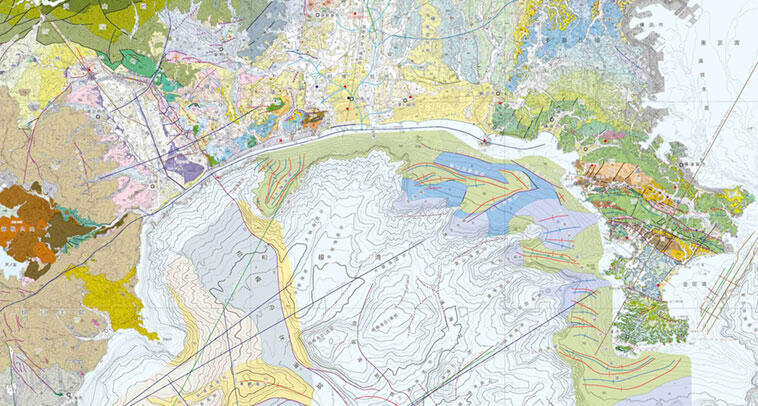
| (11)10万分の1相模湾沿岸域の地質図及び説明書(尾崎正紀・佐藤智之・水野清秀) (11) 1:100,000 Geological map of the coastal zone of the Sagami Bay and its explanatory notes by Ozaki M., Sato T. and Mizuno K. |
10万分の1地質図(PDF/36.4MB) 説明書(PDF/3.8MB) 第2図(PDF/9.6MB) 第3図(PDF/968KB) |