S-5. 海陸シームレス地質情報集「駿河湾北部沿岸域」(平成28年7月20日出版)
S-5. Seamless Geoinformation of Coastal Zone “Northern Coastal Zone of Suruga Bay” (Published July 20, 2016)
 駿河湾北部沿岸域は、フィリピン海プレートの西南日本弧(ユーラシアプレート)への沈み境界である南海トラフの東端部に位置します。そのプレートの境界は、駿河湾から富士川下流域、富士山西方へと南北に延び、そこには日本で最大級の活動度が推定されている富士川河口断層帯が発達しています。調査は、海陸沿岸域のシームレスな地質・地球物理情報の整備、富士川河口断層帯の活動性と海陸での連続性の把握などを目的として、反射法地震探査、高精度音波探査、表層堆積物調査、ボーリング調査、地質・活断層踏査、海底地形調査、地球物理調査、地下水調査を、主に平成25年度に実施しました。その結果、富士川河口断層帯の海域への連続性などが明らかとなり、以下のように成果をまとめ、 Web公開しました。
※ダウンロードの際は、容量が大きなファイルもありますので、ご注意下さい。
※容量縮小版は、画像の解像度が低く、印刷には適さないものがあります。
| コンテンツ Contents | PDFファイル等 PDF Files, etc. |
|---|---|
| 全体 All |
|
| read me (j) read me (e) |
Readme(ZIP/333KB) |
| 調査地域マップ Study area map |
調査地域図(PDF/751KB) |
| (0) 序文(田中裕一郎) (0) Preface by Y. Tanaka |
序文(PDF/128KB) |
| (1) 20万分の1駿河湾北部沿岸域海底地質図及び説明書(佐藤智之・荒井晃作) (1) 1:200,000 Marine geological map of the northern coastal zone around Suruga Bay, and its explanatory notes, by T. Sato and K. Arai |
20万分の1海底地質図(PDF/818KB) 説明書(容量縮小版)(PDF/9.1MB) 説明書(PDF/53.4MB) 測線図(PDF/292KB) 高分解能音波探査断面(ZIP/588MB) 高分解能音波探査解釈断面(ZIP/7.9MB) |
| (2) 駿河湾北部沿岸域の海底堆積物の特徴とその堆積プロセス(西田尚央・池原 研) (2) Spatial variation of coastal marine sediments of the northern Suruga Bay, central Japan and their depositional processes, by N. Nishida and K. Ikehara |
説明書(容量縮小版)(PDF/2.1MB) 説明書(PDF/29.2MB) 図版(ZIP/81MB) |
| (3) 駿河湾北部沿岸域における平野地下の浅部地質構造(石原武志・水野清秀) (3) Shallow geological structure in the coastal area of the northern Suruga Bay, Japan, by T. Ishihara and K. Mizuno |
説明書(容量縮小版)(PDF/2.6MB) 説明書(PDF/14.5MB) |
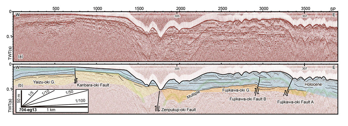
| (4) 富士川河口地域における反射法地震探査(伊藤 忍・山口和雄) (4) Seismic Reflection Survey around the mouth of Fuji River, by S. Ito and K. Yamaguchi |
説明書(容量縮小版)(PDF/1.5MB) 説明書(PDF/9.9MB) |
| (5) 静岡市三保半島先端陸域の浅部地下構造(山口和雄・伊藤 忍) (5) Shallow subsurface structure onshore at tip of the Miho Peninsula, Shizuoka City, central Japan, by K. Yamaguchi and S. Ito |
説明書(容量縮小版)(PDF/3.4MB) 説明書(PDF/19.3MB) |
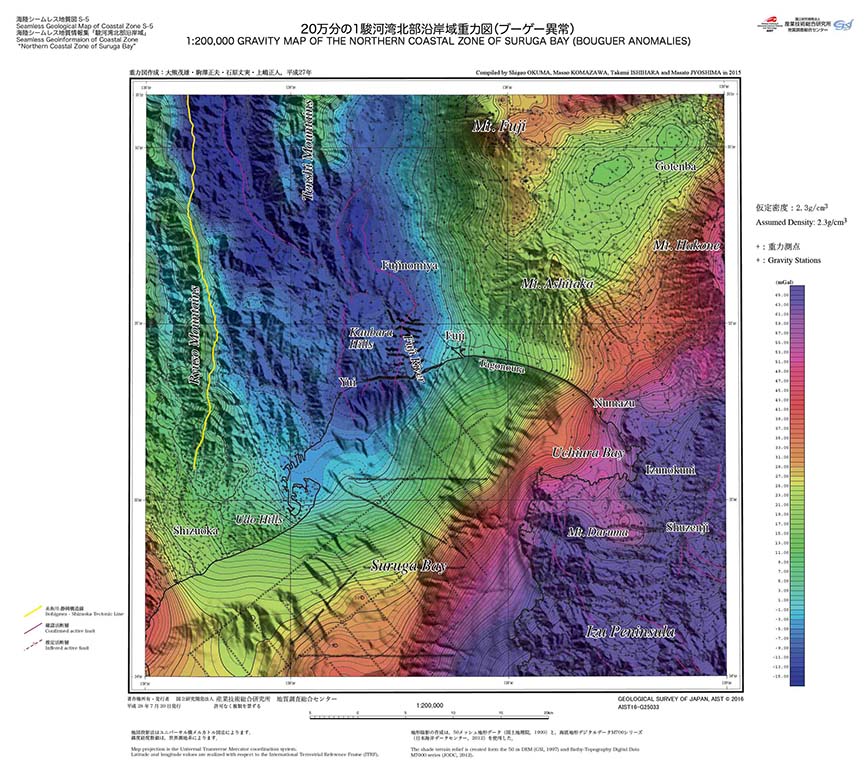
| (6) 20万分の1駿河湾北部沿岸域重力図(ブーゲー異常)及び説明書(大熊茂雄・駒澤正夫・石原丈実・上嶋正人) (6) 1:200,000 Gravity map of the northern coastal zone of Suruga Bay (Bouguer Anomalies) and its explanatory notes, by S. Okuma, M. Komazawa, T. Ishihara and M. Joshima |
20万分の1重力図(PDF/6.7MB) 説明書(容量縮小版)(PDF/2MB) 説明書(PDF/15.3MB) 重力グリッドデータ(TXT/3.8MB) 重力測定データ(TXT/17KB) |
| (7) 20万分の1駿河湾北部沿岸域空中磁気図(全磁力異常)及び説明書(大熊茂雄・中塚 正・山谷祐介) (7) 1:200,000 Aeromagnetic map of the northern coastal zone of Suruga Bay (Total Magnetic Intensity) and its explanatory notes, by S. Okuma, T. Nakatsuka and Y. Yamaya |
20万分の1空中磁気図(PDF/6.2MB) 説明書(容量縮小版)(PDF/2.6MB) 説明書(PDF/23.5MB) |
| (8) 富士山周辺の水文調査(井川玲欧・小野昌彦・神谷貴文・渡邊雅之・村中康秀・平野智章・丸井敦尚) (8) Hydrological research around Mt. Fuji, by R. Ikawa, M. Ono, T. Kamitani, M. Watanabe, Y. Muranaka, T. Hirano and A. Marui |
説明書(容量縮小版)(PDF/3.5MB) 説明書(PDF/17.5MB) |
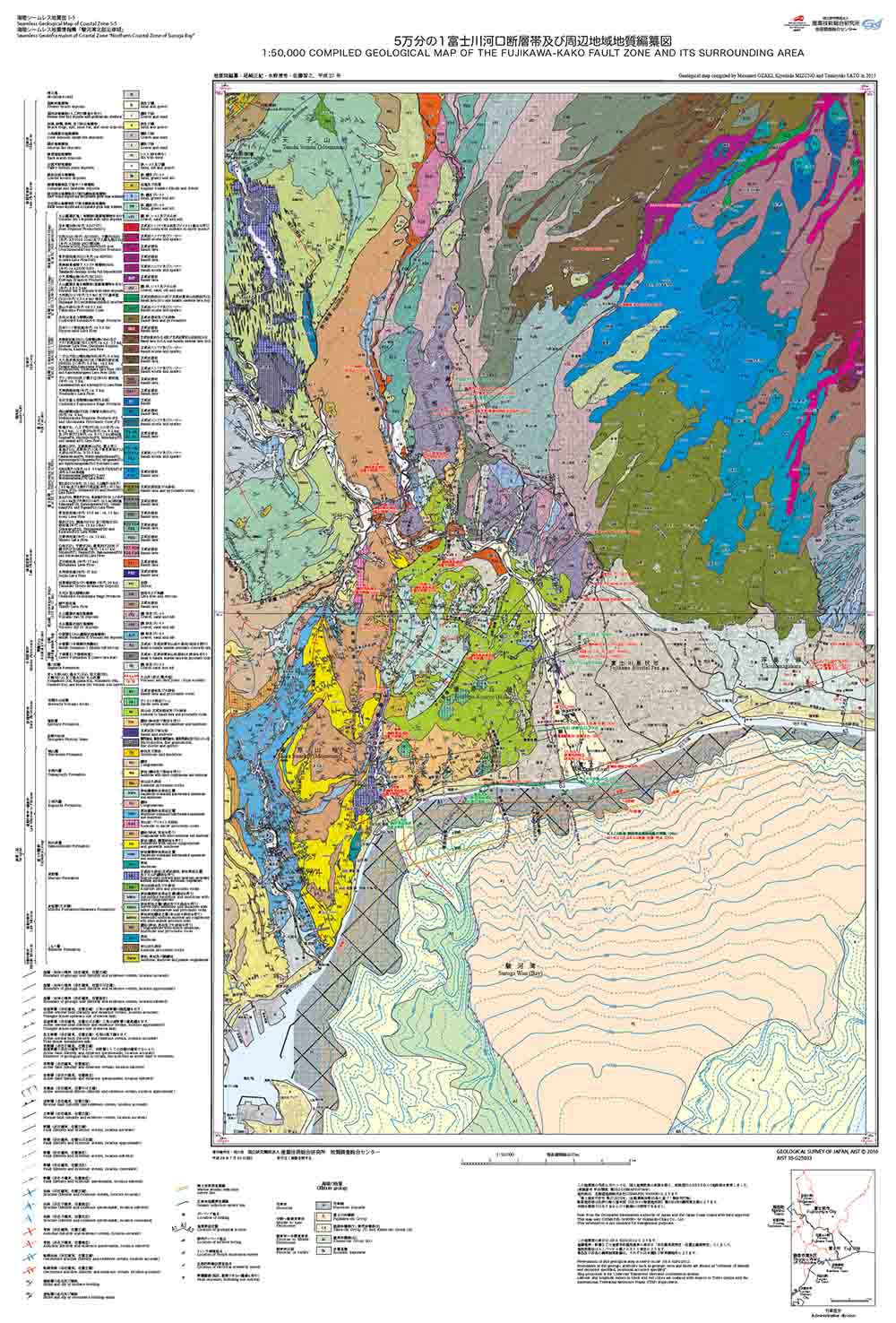
| (9) 5万分の1富士川河口断層帯及び周辺地域地質編纂図及び説明書(尾崎正紀・水野清秀・佐藤智之) (9) 1:50,000 Compiled geological map of the Fujikawa-kako Fault Zone and its surrounding area, and explanatory notes, by M. Ozaki, K. Mizuno and T. Sato |
5万分の1富士川河口断層帯地質図(PDF/4.7MB) 5万分の1富士川河口断層帯断面図(PDF/882KB) 説明書(容量縮小版)(PDF/3.6MB) 説明書(PDF/12.2MB) |
| (10) 5万分の1富士川河口断層帯及び周辺地域地質−重力図(大熊茂雄・駒澤正夫・石原丈実・上嶋正人・尾崎正紀・水野清秀・佐藤智之) (10) 1:50,000 Compiled geological map with gravity contours of the Fujikawa-kako Fault Zone and its surrounding area, by S. Okuma, M. Komazawa, T. Ishihara, M. Joshima, M. Ozaki, K. Mizuno and T. Sato |
5万分の1富士川河口断層帯地質—重力図(PDF/4.9MB) 説明(PDF/44KB) |
| (11) 5万分の1富士川河口断層帯南部地質−空中磁気図(大熊茂雄・中塚 正・山谷祐介・尾崎正紀・水野清秀・佐藤智之) (11) 1:50,000 Compiled geological map with aeromagnetic contours of the southern part of the Fujikawa-kako Fault Zone , by S. Okuma, T. Nakatsuka, Y. Yamaya, M. Ozaki, K. Mizuno and T. Sato |
5万分の1富士川河口断層帯南部地質-空中磁気図(PDF/3.6MB) 説明(PDF/42KB) |
| (12) 20万分の1駿河湾北部沿岸域海陸地質図(尾崎正紀・佐藤智之・荒井晃作) (12)1:200,000 Marine and land geological map of the northern coastal zone of Suruga Bay, by M. Ozaki, T. Sato and K. Arai |
20万分の1海陸地質図(PDF/3.4MB) 説明(PDF/56KB) |
| (13) 20万分の1駿河湾北部沿岸域地質−重力図(大熊茂雄・駒澤正夫・石原丈実・上嶋正人・尾崎正紀・佐藤智之・荒井晃作) (13) 1:200,000 Geological map with gravity contours of the northern coastal zone of Suruga Bay, by S. Okuma, M. Komazawa, T. Ishihara, M. Joshima, M. Ozaki, T. Sato and K. Arai |
20万分の1地質-重力図(PDF/4.4MB) 説明(PDF/41KB) |
| (14) 20万分の1駿河湾北部沿岸域地質−空中磁気図(大熊茂雄・中塚 正・山谷祐介・尾崎正紀・佐藤智之・荒井晃作) (14) 1:200,000 Geological map with aeromagnetic contours of the northern coastal zone of Suruga Bay, by S. Okuma, T. Nakatsuka, Y. Yamaya, M. Ozaki, T. Sato and K. Arai |
20万分の1地質-空中磁気図(PDF/4MB) 説明(PDF/39KB) |