S-4. 海陸シームレス地質情報集「石狩低地帯南部沿岸域」(平成26年9月30日出版)
S-4. Seamless Geoinformation of Coastal Zone “Southern Coastal Zone of the Ishikari Depression” (Published September 30, 2014)
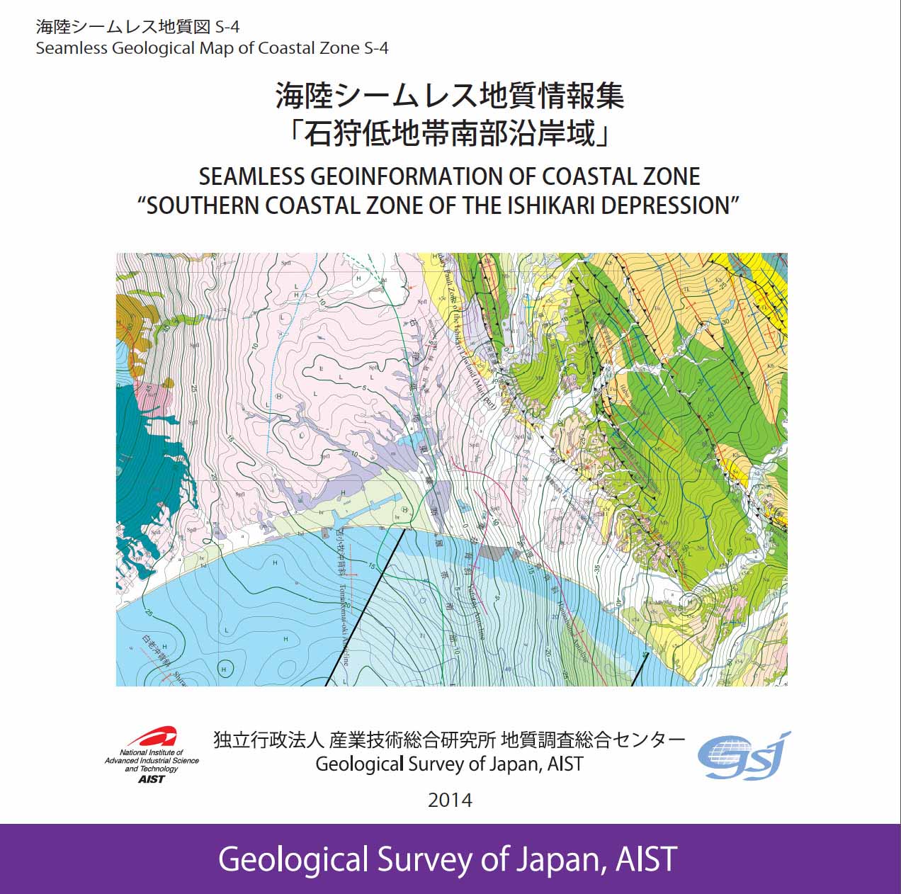 石狩低地沿岸域は、石狩平野〜勇払平野とその南側の太平洋側沿岸海域を含みます。西側には東北日本弧の北端部に位置する支笏カルデラ火山などが発達する火山弧を、東側には東北日本弧と千島弧の衝突帯である夕張山地を配し、地質構造は全体として南北〜北北西-南南東方向の逆断層及び褶曲構造で特徴づけられます。平成24年度に調査を終え、平成26年度中に成果をとりまとめました。
※ダウンロードの際は、容量が大きなファイルもありますので、ご注意下さい。
※容量縮小版は、画像の解像度が低く、印刷には適さないものがあります。
| DVD-ROMコンテンツ DVD-ROM Contents | PDFファイル等 PDF Files, etc. |
|---|---|
| 全体 All |
|
| read me (j) read me (e) |
Readme(ZIP/158KB) |
| 調査地域マップ Study area map |
調査地域マップ(PDF/1.3MB) |
| (0) 序文(岡村行信) (0) Preface by Y. Okamura |
序文(PDF/127KB) |
| (1) 勇払平野沿岸域20万分の1海底地質図及び説明書 (佐藤智之) (1) 1:200,000 Marine geological map along the coastal zone around Yufutsu Plain with explanatory notes, by T. Sato |
海底地質図(PDF/883KB) 説明書(容量縮小版)(PDF/14.8MB) 説明書(PDF/44MB) 高分解能音波探査断面(ZIP/121.6MB) 高分解能音波探査解釈断面(ZIP/116.9MB) |
| (2) 北海道勇払沖陸棚上の堆積物と堆積作用 (片山 肇・内田康人・輿水健一・西田尚央・池原 研・中島 礼) (2) Sediments and sedimentation on the shelf off Yufutsu, Hokkaido, Japan, by H. Katayama, Y. Uchida, K. Koshimizu, N. Nishida, K. Ikehara, and R. Nakashima |
説明書(容量縮小版)(PDF/7.4MB) 説明書(PDF/29.9MB) |
| (3) 石狩低地帯及び周辺地域の20万分の1陸域地質図及び説明書 (尾崎正紀・小松原 琢) (3) 1:200,000 Land geological map in the Ishikari Depression and its surrounding area with explanatory note, by M. Ozaki and T. Komatsubara |
陸域地質図(PDF/3.4MB) 説明書(PDF/3MB) |
| (4) 勇払平野と支笏火砕流台地地下の上部第四系層序ボーリング (小松原 琢・小松原純子・田辺 晋・本郷美佐緒・植木岳雪・中島 礼・石原武志) (4) The boring survey of the upper Quaternary in the Yufutsu Plain and Shikotsu Pyroclastic Flow Upland, central Hokkaido Island, northern Japan, by T. Komatsubara, J. Komatsubara, M. Hongo, S. Tanabe, T. Ueki, R. Nakashima, and T. Ishihara |
説明書(容量縮小版)(PDF/4.4MB) 説明書(PDF/12.1MB) 付表(古地磁気測定、珪藻・花粉分析、火山ガラスの主成分化学組成)(ZIP/14.8MB) |
| (5) 勇払平野と支笏火砕流台地地下の地下地質と活構造 (小松原 琢・康 義英・小松原純子) (5) Subsurface geology and active structures beneath the Yufutsu Plain and Shikotsu Pyroclastic Flow Upland, by T. Komatsubara, Y. Kou, and J. Komatsubara |
説明書(容量縮小版)(PDF/5.3MB) 説明書(PDF/55.8MB) |
| (6) ボーリングデータ解析に基づく長沼低地と隣接地域の浅部地下地質モデル (木村克己・康 義英・花島裕樹) (6) The shallow-level subsurface geologic structure based on analysis of borehole data in the Naganuma lowland and the adjacent area of the central Ishikari Lowland Zone, Hokkaido, by K. Kimura, Y. Kou and Y. Hanashima |
説明書(容量縮小版)(PDF/11.2MB) 説明書(PDF/17.9MB) |
| (7) 勇払周辺の新たな反射法地震探査データの解析 (横倉隆伸・山口和雄・岡田真介) (7) Processing of seismic reflection survey data newly conducted around the Yufutsu area, Hokkaido, Japan, by T. Yokokura, K. Yamaguchi, and S. Okada a |
説明書(容量縮小版)(PDF/13.8MB) 説明書(PDF/119.5MB) 高解像度図面(ZIP/91.8MB) |
| (8) 勇払周辺の反射法地震探査データ再解析 (山口和雄・横倉隆伸・岡田真介・阿部 進) (8) Re-processing of offshore and onshore seismic reflection survey data around Yufutsu area, Hokkaido, Japan, by K. Yamaguchi, T. Yokokura, S. Okada, and S. Abe |
説明書(容量縮小版)(PDF/7.8MB) 説明書(PDF/89.4MB) |
| (9) 石狩低地帯及び周辺地域の20万分の1重力図 (ブーゲー異常)及び説明書(駒澤正夫・大熊茂雄・上嶋正人) (9) 1:200,000 Gravity map of the Ishikari Depression and its surrounding area (Bouguer Anomalies) with explanatory notes, by M. Komazawa, S. Okuma, and M. Joshima |
重力図(PDF/21.5MB) 説明書(容量縮小版)(PDF/2MB) 説明書(PDF/9.7MB) 重力グリッドデータ(TXT/8.8MB) 重力測地点データ(TXT/67KB) |
| (10) 石狩低地帯及び周辺地域の20万分の1空中磁気図 (全磁力異常)及び説明書(大熊茂雄・中塚 正) (10) 1:200,000 Aeromagnetic map of the Ishikari Depression and its surrounding area (Total Magnetic Intensity) with explanatory notes, by S. Okuma and T. Nakatsuka |
空中磁気図(PDF/13.7MB) 説明書(容量縮小版)(PDF/3.5MB) 説明書(PDF/70.7MB) |
| (11) 石狩低地帯南部と勇払平野沖の活構造と沖積層基底の埋没地形面 (佐藤智之・小松原 琢) (11) Active structures and basal topography of the Alluvium (Post-glacial deposits) in the southern part of the Ishikari Depression and off Yufutsu region, central Hokkaido, by T. Sato and T. Komatsubara |
説明書(容量縮小版)(PDF/3MB) 説明書(PDF/10MB) |
| (12) 反射法地震探査結果から見た石狩低地東縁断層帯南部周辺の地下地質構造 (横倉隆伸・岡田真介・山口和雄) (12)Subsurface geological structure revealed by seismic reflection surveys around the southern part of the eastern boundary fault zone of the Ishikari lowland, Hokkaido, Japan, by T. Yokokura, S. Okada, and K. Yamaguchi |
説明書(容量縮小版)(PDF/10.8MB) 説明書(PDF/143.57MB) 高解像度図面(ZIP/349MB) |
| (13) 石狩低地帯及び周辺地域の20万分の1海陸地質図 (佐藤智之・尾崎正紀・小松原 琢) (13) 1:200,000 Marine and land geological map of the Ishikari Depression and its surrounding area, by T. Sato, M. Ozaki, and T. Komatsubara |
海陸地質図(PDF/3.5MB) |
| (14) 石狩低地帯及び周辺地域の20万分の1地質-重力図 (駒澤正夫・大熊茂雄・上嶋正人・佐藤智之・尾崎正紀・小松原 琢) (14) 1:200,000 Geological map with gravity contours of the Ishikari Depression and its surrounding area, by M. Komazawa, S. Okuma, M. Joshima, T. Sato, M. Ozaki, and T. Komatsubara |
地質-重力図(PDF/6.1MB) |
| (15) 石狩低地帯及び周辺地域の20万分の1地質-空中磁気図 (大熊茂雄・中塚 正・佐藤智之・尾崎正紀・小松原 琢) (15) 1:200,000 Geological map with aeromagnetic contours of the Ishikari Depression and its surrounding area, by S. Okuma, T. Nakatsuka, T. Sato, M. Ozaki, and T. Komatsubara |
地質-空中磁気図(PDF/4.4MB) |
| (16) 石狩低地帯及び周辺地域の20万分の1空中磁気-重力図 (大熊茂雄・駒澤正夫・中塚 正・上嶋正人) (16) 1:200,000 Aeromagnetic map with gravity contours of the Ishikari Depression and its surrounding area, by S. Okuma, M. Komazawa, T. Nakatsuka, and M. Joshima |
空中磁気-重力図(PDF/15.5MB) |