地質調査研究報告 トップへ
地質調査研究報告 Vol.52 No.8 (2001)
表紙
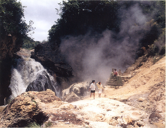
中国雲南省騰冲の熱海地熱地帯
中国の雲南省西部は、インド亜大陸の衝突の影響を受けて、現在も激しい地殻変動が続き、地震も多い。ビルマ (ミャンマー) 国境に近い騰冲 (Tengchong) 地域には、17世紀初頭に噴火したとの言い伝えが残る第四紀火山群があり、活発な地熱活動を伴う。多数の高温泉が主に断層に沿って湧出し、最も活動的な熱海 (Rehai) 地域では、温泉型金鉱床が発見されている (佐藤ほか (1997) : 中国雲南省騰冲の温泉型金鉱床、『地質ニュース』no.513, 49-55 参照)。騰冲市街の南約 10km 余りにある熱海地熱地帯の中心地 = 硫黄塘 (Liuhuangtang) は温泉保養地としても知られ、観光客が訪れる。写真は澡塘 (Zaotang) 河川床の沸騰泉の寸景 (1994年7月撮影)。
(写真と文 : 佐藤興平)
目次
| タイトル | 著者 | |
|---|---|---|
| 論文 | ||
| 中国西南部三江造山帯における地熱地帯及び温泉型鉱床の地質と地学的特徴 | 王 平安 |
52_08_01.pdf [4,281 KB] |
| 関東平野における沖積層土壌の化学組成 -土壌地球化学図の基礎研究 (第2報)- | 寺島 滋・ |
52_08_02.pdf [4,366 KB] |
| 概報 | ||
| Geochemistry of bottom sediments from a river-estuary-shelf mixing zone on the tropical southwest coast of India | SHAJAN Kuttickat Paul(371-382) | 52_08_03.pdf [1,882 KB] |
要旨集
Geology and geochemistry of geothermal fields and hot-spring type gold deposits in Sanjiang orogen, southwestern China
Pin'an WANG
Sanjiang orogen is a NS-trending sollisional orogenic belt between Indian plate and Yangyze block of the South China plate, and also an important metallogenetic belt in southwestern China. The collision process between Eurasia plate and Indian plate started from Mesozoic times, which resulted in strong and frequent magmatic activities then after. After Cenozoic, the stronger and more frequent tectono-magmatism and volcanic eruptions provided fracture spaces and plenty of heat sources for epithermal activity in this area.
As an active geothermal field, the Rehai geothermal field situates in the southern part of the Sanjiang orogen, and is composed of two sub-scale geothermal fields-the Huanggua-qing-Liuhu-ang-tang in northeast and Reshui-tang in southwest. Rocks that outcrop in this geothermal field are mainly late Cretaceous granitoids with minor late Tertiary and Quaternary volcanics, sand-stone and conglomerate. Strong volcanisms in Pliocene to Pleistocene were recognized and early Pleistocene dacite and andicitic terrestrial volcanics distribute in the Huanggua-qing-Liuhuang-tang geothermal field (i.e.Rehai geothermal field in narrow sence). 62 hot spring groups occur along a NS-striking main fault in the Rehai geothermal field. Hydrochemical types of the spring water are mainly Na-Ca-HCO3 and Na-HCO3-Cl types; secandly Na-SO4 type, Na-Cltype, Ca-Na-HCO3-SO4 type and Mg-Ca-HCO3 type. Temperature of spring water on the surface is 24 ~ 102ºC, and pH value is 2 ~ 9.8. Geothermometers of SiO2, Na/K, Na-K-Ca, and Na-K-Ca-Mg, of the hot spring waters in the Rehai geothermal field, were used to evaluate the reservoir temperature, which yielded results of >270 ~ 100ºC from below 600m to the surface. The hydrothermal alteration and gold mineralization process are still going on that area, and the Lianghe gold deposit was formed between the Zao-tang River and the Xiao-shui River in Liuhuang-tang-Huanggua-qing geothermal area in the northeast sector of the geothermal field. This deposit about 6km² in area, with several kinds of spring sinter, hydrothermal alteration and breccia, and is one of the most recently formed hot spring-type gold deposits in China.
Spring sinters are of mainly silica sinter, with limited travertine, effloresce, flower of sulfur (sublimation sulfur) and gypsum sinter. Silica sinter is composed mainly of chalcedony and opal with mimor pyrite, marcasite, coffinite and pichblende. Gold content is 0.08 ~ 0.4g/t in present silica sinter, and 0.1 ~ 0.8g/t in fossil silica sinter.
Pyritization, silicification, argillic slteration, propylitization, sericitization, alunitization, zeolituzation and adularization are the major hydrothermal alteration types in the geothermal field and the Lianghe Au deposit where acid leaching alteration is widely developed. The alterationmineralization zoning from central part outward across a fault or fracture is as follows: strong silicified gold-bearing quartz zone → silicified-argillic altered zone → argillic altered zone → propylitization zone. Kaolinite, alunite, smectite, illite and dickite were formed by argillic alteration in acid leaching process. Very well-oldered kaorlinite in the Rehai geothermal field is found to be the best-ordered in China up to now, which has an Hc value of 1.67. Layered silica caps, fine quartz veins and stock work vein penetrating into acid leaching zone, are main appearances of Au mineralization.
Gold ore bodies ocure in NS-striking altered fractur zone as steeply dipping veins and complex veins accompanied by hydrothermal breccia. Ores are banded, lamellar, brecciform, and arsenopyrite, galena, and are composed of pyrite and marcasite as major metal minerals, and arsenopyrite, galena, sphalerite, chalcopyrite, stibnite, and nativ gold as minor metal minerals. Gangue minerals aer quartz, chalcedony, opal, jasper, with minor kaolinite, aluminite, illite, smecite, sericite, fluorite, and calcite.
Au content in hot spring water, surface sinter, bottom sinter, acid leaching zone, and stockwork quartz veins, is 0.01 ~ 0.16ppb, 0.001 ~ 0.63ppm, 0.004 ~ 0.17ppm, 0.001 ~ 0.73ppm, and 0.003 ~ 4.65ppm, respectively. Ag content in silica cap reaches 0.001 ~ 54.5ppm. Based on the average of Au and Ag content, Au/Ag ratio is always less that 0.1 (1:10 ~ 1:19). δ18OH2O, δDH2O, and δ13Cco2 values of hot spring waters in the Tengchong-Lianghe area are -12.3‰ ~ -5.1‰, -68.9‰ ~ -55.7‰, and -5.2‰ ~ -1.6‰, respectively. δ34S values of hot spring water, native sulfur, and sulfides such as pyrite, are mainly -2‰ ~ +2‰. Liquid composition of fluid inclusions in quartz from breccia of Liuhuangtang area is H2O 72%, H2S 28%; vapor composition is CO2 67.1%, H2S 12.6%, and H2 20.3%.
The δ18O values for quartz from quartz veins in the Lianghe gold deposit are between 5.0‰ and 8.8‰ (averaged 7.3‰ for 10 samples), and 2.3‰ ~ 12.4‰ (averaged 7.6‰ for 6 samples) for silicified Pliocene sandstone (whole rock).
Soil and rock geochemical investigation results suggest a tendency of high concentration or anomalies of Bi, Li, Rb, As, Sb, Hg, and Sn in or near hot spring areas, and Mn, Ni, Co, Pb, and Zn around or out of hot spring areas.
関東平野における沖積層土壌の化学組成
-土壌地球化学図の基礎研究 (第2報)
寺島 滋・太田充恒・今井 登・岡井貴司・御子柴真澄・谷口政碵
土壌地球化学図の作成に関する予察的研究の一環として、関東各地の沖積層から柱状試料を採取して主・微量元素を分析し、土壌の母材や元素の広域分布特性、地球化学的挙動等を研究した。沖積層土壌における元素濃度の鉛直変化は、火山噴出物と河川由来砕屑物であり、両者の割合は地形・地質的な要因で変化する。沖積層土壌 における元素濃度の鉛直変化は、火山灰質土のそれに比べて小さかった。これは 堆積速度が速く、表層〜下層の風化度や腐植含有量の差が小さいためと考えられた。 沖積層土壌中砂質粒子は主として河川由来である。砂質粒子は風化・変質に伴って微細化するが、この際アルカリ・アルカリ土類金属が溶出し・流失し、細粒部では アルミニウム、チタン、各種重金属等が相対的に高濃度になる。山間部の規模が小さい沖積面では、集水域の基盤地質と土壌の化学組成の特徴は類似する。広大な平野部を流下する河川の下流域では、基盤岩砕屑物は均質化されており、 粒度組成の相違が化学組成を変動させる主因である。沖積層土壌の化学組成は、同一地域の火山灰質土に比べてアルミニウム、チタン、重金属類に乏しく、アルカリ・アルカリ土類金属に富む特徴があり、概括的には河川や湖沼の堆積物に類似する。
熱帯インド南西沿岸沿岸における河川-汽水-沿岸域底質堆積物の地球化学
SHAJAN Kuttickat Paul
インド南西部岸、Kerala 州沿岸域の Periyar, Muvattupuzha 川及び Cochin 汽水域周辺の底質堆積物の地化学的検討を行い、元素の分布と濃集パターン、起源、そして元素分布の規制要因と環境からの混入について検討した。河川堆積物試料は砂質シルトないし砂で、汽水性および沿岸堆積物はシルト砂質から泥である。検討の結果、堆積物粒度組成が元素分布の主要な規制要因であることが明らかになった。汽水性ならびに沿岸堆積物では Mn, Ca, Al, Ti, Fe, Na, P, K, Mg, Li, Sc, V, Cr, Ni, Cu, Zn, As, Rb, Ta, Zr, Nb, Pb そして灼熱減量組成に富み、Si に乏しい。有機物に富む試料でも同様な Fe, Al, Mg, P, Cu, Ni, Co, Cr そして V の挙動を示す。その他の可能性のある元素濃集要因として、Fe/Mn 水酸化合物による金属元素の吸着と重鉱物の濃集が あげられる。Fe, Mg, P, Zn, Ba, Pb, Cd, Bi そして Cr は多くの試料で濃集しているが、これは全ての試料に人為的汚染が生じており、特に Periyar 川とその河口域にもっとも大きな重金属類の濃集が認められる。
(要旨翻訳 : 渡部芳夫 (深部地質環境研究センター))
出版物とサービス
- お知らせ(出版物)
- 地質図カタログ
- 購入案内
-
地質調査研究報告
- 2026年 (Vol.77)
- 2025年 (Vol.76)
- 2024年 (Vol.75)
- 2023年 (Vol.74)
- 2022年 (Vol.73)
- 2021年 (Vol.72)
- 2020年 (Vol.71)
- 2019年 (Vol.70)
- 2018年 (Vol.69)
- 2017年 (Vol.68)
- 2016年 (Vol.67)
- 2015年 (Vol.66)
- 2014年 (Vol.65)
- 2013年 (Vol.64)
- 2012年 (Vol.63)
- 2011年 (Vol.62)
- 2010年 (Vol.61)
- 2009年 (Vol.60)
- 2008年 (Vol.59)
- 2007年 (Vol.58)
- 2006年 (Vol.57)
- 2005年 (Vol.56)
- 2004年 (Vol.55)
- 2003年 (Vol.54)
- 2002年 (Vol.53)
- 2001年 (Vol.52)
- 活断層・古地震研究報告
- GSJ 地質ニュース
- CCOP-GSJ 地下水プロジェクトレポート
- GSJ技術資料集
- ビデオ・パンフレット・ポスター
- その他の出版物