Bulletin of the Geological Survey of Japan Vol.51 No.9 (2000)
Cover photograh | Table of Contents |
Cover photograh
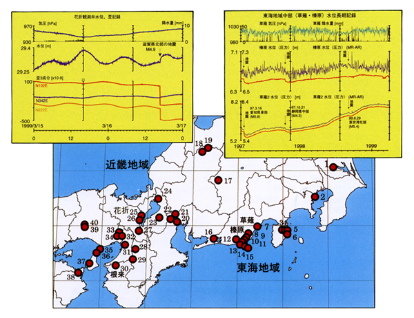
Location map of comprehensive observation wells
The Geological Survey of Japan has been monitoring groundwater levels of observation wells around the Tokai-Izu region since 1976 for the purpose of clarifying the mechanism of hydrological precursors of earthquakes. After the 1995 Hyogo-ken Nanbu Earthquake, we made an observation network composed of about 30 wells mainly along active faults in and around the Kinki area for monitoring active faults. 18 wells have 3 components strain meters and seismometers etc. besides water level sensors. The upper right figure is an example of long period records of water levels at Haibara and Kusanagi in the Tokai region. These clearly show coseismic change in water level. The upper left figure shows a result of water level and 3 component strains at Hanaore before and after the earthquake (M4.9) in the northern part of Shiga Prefecture. The epicentral distance is only l2km. We have been carefully studying precursory changes in the records.
Table of Contents
Special Issue:Earthquake potential evaluation by active faults investigation and other means: Achievement and future development of earthquake research on the 5th anniversary of the Hyogoken-nanbu Earthquake
| Title | Author | |
|---|---|---|
| Preface | Tetsuro NODA (377-378) | 51-09_01.pdf(238KB) |
| Research on earthquake potential evaluation by active faults | Yuichi SUGIYAMA (379-389) | 51-09_02.pdf(6,881KB) |
| Groundwater Monitoring Studies in the Tokai Intensified Observation Area and Other Special Observation Areas for Earthquake Prediction Research | Eikichi TSUKUDA (391-400) | 51-09_03.pdf(1,446KB) |
| Laboratory studies on nucleation process of large earthquakes | Takashi SATOH, Akio CHO, Naoyuki KATO, Hironori KAWAKATA, Xinglin LEI, Koji MASUDA, Kinichiro KUSUNOSE and Mitsuhiko SIMADA (401-410) | 51-09_04.pdf(1,629KB) |
| Pleistocene sequence stratigraphy and tectonic movements in the Noda and Omiya districts, central Kanto Plain | Tsutomu NAKAZAWA and Hidenori ENDO (411-415) | 51-09_05.pdf(746KB) |
| K-Ar age of the old-somma lava flow (0S2), southeastern foot of the Hakone Volcano | Jun'ichi ITOH (417-420) | 51-09_06.pdf(1,108KB) |
| Development of a numerical simulator of fault system activity analysis – Research on the numerical simulation of crustal deformation – | Yutaka MURAKAMI (421-427) | 51-09_07.pdf(2,569KB) |
| Research on long-term earthquake forecasting based on active fault and paleoearthquake information | Yuichi SUGIYAMA (429-433) | 51-09_08.pdf(561KB) |
| Integrated Groundwater Monitoring Studies in the Intensified Observation Area and near Major Active Faults | Eikichi TSUKUDA, Naoji KOIZUMI and Yasuto KUWAHARA (435-455) | 51-09_09.pdf(1,639KB) |
| Studies on physical and chemical processes in earthquake source region | Takashi SATOH, Koichiro FUJIMOTO and Shinobu ITO (447-450) | 51-09_10.pdf(562KB) |
| A review: Project of Fuji volcano using quadrangle mapping of Fujinomiya | Akira TAKADA, Takahiro YAMAMOTO and Naomichi MIYAJI (451-457) | 51-09_11.pdf(1,090KB) |
| Research plan on Study of evaluation method of offshore active faults | Yukinobu OKAMURA and Ken IKEHARA (459-462) | 51-09_12.pdf(967KB) |
| Seismic hazard and gravity basement structure | Hidenori ENDO (463-469) | 51-09_13.pdf(2,003KB) |
| Studies on the deep subsurface structure of the plains for strong motion estimation | Hisao ITO, Takanobu YOKOKURA, Naomi KANO, Kazuo YAMAGUCHI, Masao KOMAZAWA, Yuichi SUGIYAMA, Kazutoshi IMANISHI, Tsutomu KIGUCHI, Kazuki KOKETSU and Yoshiaki HISADA (471-475) | 51-09_14.pdf(1,055KB) |