Bulletin of the Geological Survey of Japan Top Page
Bulletin of the Geological Survey of Japan Vol.74 No.5/6 (2023)
Special issue on marine geology around Tokara Islands in Kagoshima Prefecture: result of marine geological mapping survey cruises in 2021
Cover photograph | Table of Contents | Abstract
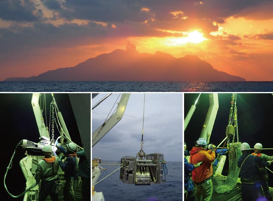
Cover photograph
Marine geological survey around the Tokara Islands, Kagoshima Prefecture, in Fiscal Year 2021
The Geological Survey of Japan (GSJ) has been published the Marine Geology Map Series (1:200,000) for Japan since the 1970s. In this special issue, we report the results of seismic reflection profiling surveys, bathymetry surveys, magnetic anomaly surveys, and submarine sediment surveys conducted around the Tokara Islands as part of the northern Okinawa Trough Project.
Upper: Sunset on Suwanosejima island, a volcanic island in the Tokara Islands archipelago in Kagoshima Prefecture. Suwanosejima is an active volcano, and ash plumes can be seen billowing from its summit.
Lower left: Deploying the seismic source (air gun) used in the seismic profiling survey.
Lower center: K-grab sampler for obtaining submarine sediment samples from the sea bottom.
Lower right: Deploying the dredge sampler for obtaining submarine rock samples.
(Photograph and Caption by INOUE Takahiko)
Table of Contents
All the pages PDF : 74_05_full.pdf [55.7MB]
| Title | Author | |
|---|---|---|
| Preface | ||
| Special issue on marine geology around Tokara Islands in Kagoshima prefecture: result of marine geological mapping survey cruises in Fiscal Year 2021 | INOUE Takahiko, ITAKI Takuya and AMANO Atsuko (p187–191) | 74_05_01.pdf [3.8MB] |
| Report | ||
| Results of the multibeam echo sounder observations on the GB21-2,3 cruises (around Tokara Islands) | KOGE Hiroaki, SATO Taichi and SUZUKI Yoshiaki (p193–202) | 74_05_02.pdf[7MB] |
| Preliminary results of the magnetic anomaly survey around Tokara Islands during the GB21-2, GB21-3, and GS21 cruises | SATO Taichi and KOGE Hiroaki (p203–209) | 74_05_03.pdf [1.7MB] |
| Overview of the seismic survey and dredge sampling in the vicinity of the Tokara Islands conducted during geological map research cruises in 2021 | ISHINO Saki, HARIGANE Yumiko, MISAWA Ayanori and INOUE Takahiko (p211–230) | 74_05_04.pdf[13MB] |
| Shallow submarine structure around Tokara Islands based on the high-resolution subbottom profiler survey during the GS21 cruise | MISAWA Ayanori, FURUYAMA Seishiro, KOGE Hiroaki and SUZUKI Yoshiaki (p231–243) | 74_05_05.pdf[9.6MB] |
| Article | ||
| Depositional ages of sedimentary rocks obtained from the sea floor around the northern Tokara Islands during GB21-3 cruise, based on calcareous microfossil assemblages, and their geological significance | ARIMOTO Jun and UTSUNOMIYA Masayuki (p245–257) | 74_05_06.pdf[3.2MB] |
| Submarine sediment distribution and its controlling factors around the Tokara Islands | SUZUKI Yoshiaki, ITAKI Takuya, KATAYAMA Hajime, KANEKO Naotomo, YAMASAKI Makoto, ARIMOTO Jun, TOKUDA Yuki, SENTOKU Asuka and SEIKE Koji (p259–286) | 74_05_07.pdf [9.7MB] |
| Report | ||
| Chemical composition of marine surface sediments around Tokara Islands (GB21-2 and 21-3 Cruise), Japan | KUBOTA Ran, OHTA Atsuyuki, TACHIBANA Yoshiko, ITAKI Takuya, KATAYAMA Hajime, SUZUKI Yoshiaki and MANAKA Mitsuo (p287–300) | 74_05_08.pdf[1.5MB] |
| Preliminary report on the benthic foraminifera in the seas surrounding the Tokara Islands, southwest Japan | HASEGAWA Shiro (p301–314) | 74_05_09.pdf [1.5MB] |
| Article | ||
| Spatial variations in the modern ostracode fauna in the adjacent sea of Tokara Islands | NAKANO Taiga, IWATANI Hokuto, SUZUKI Yoshiaki and ITAKI Takuya (p315-324) | 74_05_10.pdf[1.2MB] |
| Report | ||
| Halacarid mites collected at offshore areas of Tokara Islands during the ocean floor survey cruises GB21-1 and GB21-2 | ABÉ Hiroshi (p325–328) | 74_05_11.pdf[1.5MB] |
| Hydrogen and oxygen isotope compositions of bottom waters collected around off southwestern Tokara Islands | OIKAWA Kazuma, MIYAJIMA Toshihiro, TAKAYANAGI Hideko and IRYU Yasufumi (p329-336) | 74_05_12.pdf [1.7MB] |
| Additional data of calcareous nannofossil assemblage in a sediment sample obtained from the seafloor near the Ishigaki Island (GH18 cruise) | UTSUNOMIYA Masayuki (p337–338) | 74_05_13.pdf[399KB] |
Abstract
Results of the multibeam echo sounder observations on the GB21-2,3 cruises (around Tokara Islands)
KOGE Hiroaki, SATO Taichi and SUZUKI Yoshiaki
The high-resolution bathymetry was observed using Multibeam echosounder (MBES) as a part of an ongoing seafloor mapping around Tokara Islands, a region from latitude 28°45' N to 31°15' N, and longitude 128°50° E to 131°20' E. The bathymetry map indicates that several bathymetric highs such as Hiki Sone, Minami-Gama Sone, Gon Sone, and Tairashima Sone, are part of a continuous ridgelike feature and possibly is located on the edge of the Okinawa Trough. The backscatter intensities are relatively high around Kuchinoshima, Nakanoshima, Gajashima, Kogajajima, Suwanosejima islands, and Hiki Sone, which suggest the presence of volcanic collapse depositions around them. Such highbackscatter intensities are also shown around Akusekijima and Tairashima islands suggesting distribution of volcanic collapse depositions, too. The result indicates that volcanic activities accompanied by volcanic collapses is common along the volcanic fronts of the Tokara Islands.
Preliminary results of the magnetic anomaly survey around Tokara Islands during the GB21-2, GB21-3, and GS21 cruises
SATO Taichi and KOGE Hiroaki
Geomagnetic surveys were conducted to make a marine geophysical map in the northern part of the Tokara Islands. A total magnetic anomaly map was made based on the observed total magnetic field. In addition, a magnetic anomaly map of the whole Tokara Islands was made together with the total magnetic anomaly calculated from the vector magnetic surveys obtained in the southern Tokara Islands last fiscal year. Magnetic dipole anomalies are observed around the island arc area and several bathymetric highs, presumed to be due to volcanic activity. Geomagnetic and published gravity features suggest that the north-south trending ridge on the western side of the survey area forms the eastern edge of the Okinawa Trough containing igneous activities. A positive magnetic anomaly is observed in a part of this topographic ridge, which is presumed to be due to magnetization caused by surface volcanic activity or a deep-seated magnetic body. On the trough, a positive magnetic anomaly without seafloor bathymetry is observed. Based on the published regional magnetic map, this anomaly is considered part of a magnetic dipole anomaly, suggesting subseafloor magmatic activity.
Overview of the seismic survey and dredge sampling in the vicinity of the Tokara Islands conducted during geological map research cruises in 2021
ISHINO Saki, HARIGANE Yumiko, MISAWA Ayanori and INOUE Takahiko
Multichannel seismic survey and dredge sampling were conducted near the Tokara Islands, northwest of the northern Okinawa Trough during GB21-2, GB21-3, and GS21 cruises with the aim of constructing marine geological maps at a 1:200,000 scale. We present an overview of the seismic survey and dredge sampling results, and report characteristic geological structures along the observed seismic profiles. Seismic profiles east of the Tokara Islands reveal a sedimentary basin overlaying the acoustic basement. Within this basin, numerous WNW–ESE-trending normal faults are developed, particularly in the northern and southern sectors. We recognized an unconformity that reflects a few stages of tectonic movements during the formation of the sedimentary basin. Dredging from a lower unit outcrop yielded sedimentary rocks. Seismic profiles west of the Tokara Islands reveal a normal fault that extends almost 50 km along the western margin of a topographic high, cutting through strata and dipping to the west. In this region, the flat seafloor surrounding the topographic high displays widespread NNE–SSW trending normal faults, while ENE–WSW trending faults are exclusively found west of the nSuwanosejima Island and Akusekijima Island. Additionally, normal faults, potentially with strike-slip components, are densely concentrated in the southwestern part of the topographic high. We aim to proceed with the construction of seismic stratigraphy and the interpretation of structural history after the conclusion of all planned research cruises in the vicinity of the Tokara Islands. These results will provide further insights into the tectonic evolution of the northern Okinawa Trough and the surrounding region of the Tokara Islands.
Shallow submarine structure around Tokara Islands based on the high-resolution subbottom profiler survey during the GS21 cruise
MISAWA Ayanori, FURUYAMA Seishiro, KOGE Hiroaki and SUZUKI Yoshiaki
During the GS21 cruise, in October 2021, a high-resolution subbottom profiler (SBP) survey was conducted focusing on the volcanic front around the Tokara Islands using R/V Shinyo Maru (Tokyo University of Marine Science and Technology) to obtain geological information on the shallow subbottom structure in this area. In this paper, we summarize the shallow subbottom structure around Higashi-Shin Sone, the southern area of Gajashima Island, the Gogo Sone area, and the Amami Trough near the Tokara Islands revealed by SBP surveys. The area around Higashi-Shin Sone and the southern area of the Gajashima Island tend to have fewer faults and submarine volcanoes than the area around Gogo Sone, and the sedimentary layers consisting of stratified structures are well developed. Around Gogo Sone, depressions and stepped bathymetry, probably caused by faults, have developed, and topographic highs that are thought to be submarine volcanoes have been recognized between the islands. In the Amami Trough, a reflective surface characterized by sand waves has been observed on the northern slope of Oshima-Shin Sone. In addition, the bedding plane of the sedimentary sequence has been exposed as in a cuesta, which is a type of erosion morphology, in some places due to erosion.
Depositional ages of sedimentary rocks obtained from the sea floor around the northern Tokara Islands during GB21-3 cruise, based on calcareous microfossil assemblages, and their geological significance
ARIMOTO Jun and UTSUNOMIYA Masayuki
Calcareous nannofossil and planktic foraminiferal assemblages were examined to determine the depositional ages of sedimentary rocks obtained during GB21-3 cruise at around the Tokara Islands, northern Ryukyu arc. Depositional ages of examined microfossil-bearing samples are shown to be the Early Pleistocene (Calabrian) or younger. Several samples from the western margin of the Tane–Yaku Spur in the forearc side and from between the Higashi–Shin Sone and Sango Sone in the back-arc side, are correlated with calcareous nannofossil biozone CN14a and/or planktic foraminiferal biozone PT1a, and their depositional ages fall between 1.59 and 0.43 Ma during the Early–Middle Pleistocene (Calabrian–Chibanian). The other younger samples are correlated with calcareous nannofossil biozone CN15, which constrains the depositional ages younger than 0.29 Ma (Middle Pleistocene to Recent). Our observation on lithology and microfossil assemblages imply that the sedimentary rock units which derived the examined samples likely have geological records of volcanogenic sedimentation and tectonic influence on uppermost crustal recycling at the northern Ryukyu arc during the Pleistocene.
Submarine sediment distribution and its controlling factors around the Tokara Islands
SUZUKI Yoshiaki, ITAKI Takuya, KATAYAMA Hajime, KANEKO Naotomo, YAMASAKI Makoto, ARIMOTO Jun, TOKUDA Yuki, SENTOKU Asuka and SEIKE Koji
Surface sediment sampling was conducted at 102 sites during two marine geological survey cruises (GB21-2 and GB21-3) around the Tokara Islands. Muddy sediments are generally distributed on the flat seafloor below 800 m depth, and are strongly bioturbated in many sites. The distribution of sandy sediments, gravels, and outcrops is not necessarily limited to shallow water depths, but coarsegrained materials of biogenic and non-biogenic sources were observed in and around islands as well as shallow water areas. This distribution of bottom sediments is believed to be influenced by the presence of submarine volcanoes which are a potential source of sediments beneath the seafloor, in addition to islands and shallow-water areas where biological production occurs. The distribution of bedforms such as ripples, outcrops, and gravelly sediments, commonly found around islands, suggests a strong influence of the meandering Kuroshio Current in this area. Analyses of bryozoans, coral distribution, assemblages, size distribution, and preservation of planktic foraminifera suggest that the Kuroshio Current exerts both mechanical effects, through bottom currents, and biological effects, such as on community composition and the body size of organisms, on the sediments.
Chemical composition of marine surface sediments around Tokara Islands (GB21-2 and 21-3 Cruise), Japan
KUBOTA Ran, OHTA Atsuyuki, TACHIBANA Yoshiko, ITAKI Takuya, KATAYAMA Hajime, SUZUKI Yoshiaki and MANAKA Mitsuo
The concentrations of 24 elements in the 90 marine surface sediment samples collected from around Tokara Islands, were determined, and the characteristics of the chemical composition and concentration distribution were investigated. The sediments in this sea area are considered to be derived from three sources: bioclasts rich in CaO and Sr, mafic clastic materials rich in T-Fe2O3 and MgO, and felsic clastic materials rich in K2O. The contribution of the three sources differs depending on the sampling area. The analysis results of the relationship between the concentrations of each element suggests that the contribution of mafic clastic particles is particularly large in the off eastern Suwanose Island (Central zone of Tokara Islands). Samples having high Cu concentrations are distributed mainly in the Central zone of Tokara Islands, although they are not always enriched in T-Fe2O3 and TiO2 concentrations. The high Cu concentration samples in Southern zone of Tokara Islands would be influenced by the early diagenesis process because they are also abundant in MnO concentrations.
Preliminary report on the benthic foraminifera in the seas surrounding the Tokara Islands, southwest Japan
HASEGAWA Shiro
Four depth zones are recognized based on occurrence of benthic foraminifera at 73 sites from 185 to 1,200 m depths during GB21-1, 2 and 3 cruises around the Tokara Islands. These depth zones correspond to previously reported Zones II to V around the Nansei Islands.However, there is a clear difference in water depth of those zones between the northern part (this sea) and southern end (Yaeyama Islands) in the Nansei Islands. This difference is thought to be related to the geographic variation of the stratified structure by the Kuroshio and intermediate/deep water in the East China Sea.
At some sites, abnormal values are shown in the depth distribution of foraminiferal indicators such as benthic and planktonic foraminiferal numbers, proportion among three types of test composition in benthic foraminifera, proportion of planktonic one in total foraminifera (PF%).Those peculiar occurrences of foraminiferal assemblages are presumed to have been locally formed by remarkable relief of seafloor due to volcanic activity in the Tokara Islands and the strong flow of the Kuroshio Current in this area.
Spatial variations in the modern ostracode fauna in the adjacent sea of Tokara Islands
NAKANO Taiga, IWATANI Hokuto, SUZUKI Yoshiaki and ITAKI Takuya
We studied the spatial distribution of the modern ostracode in the “Tokara gap”. We examined the ostracod faunal composition in 5 surface sediments collected by GB21-3 cruise (AIST). As a result, at least 150 species of ostracods in 54 genera were identified. Most of the assemblages were subtropical and tropical water species that have been reported from the East China Sea. Four ostracode bioassociations and four biofacies were discriminated based on R-mode and Q-mode cluster analyses. Ostracode bioassociations and biofacies tended to vary with the mud content. We could not find a faunal change in the Tokara gap. On the other hand, the distribution of ostracode fauna was clearly changing between the East China Sea and the Philippine Sea. This spatial distribution variation might be accompanied by the change in the Kuroshio axis. The Kuroshio Current likely influenced modern ostracode fauna in the study site.
Halacarid mites collected at offshore areas of Tokara Islands during the ocean floor survey cruises GB21-1 and GB21-2
ABÉ Hiroshi
During the ocean floor survey cruises (GB21-1 and GB21-2) conducted by AIST in the sea are around the Tokara Islands in 2021, 12 species of six genera in the family Halacaridae: Copidognathus, Halacarellus, Agauopsis, Simognathus, Lohmannella, and Scaptognathus, an individual thought to be a halacarid mite but whose genus is uncertain, and one species in the family Acaridae were collected from the ocean floor sediment. Although the particle size of the sediment is known to be a limiting factor in the diversity of the halacarid genera, this survey suggests that depending on the genus, depth rather than sediment particle size and quality is a major limiting factor of distribution.
Hydrogen and oxygen isotope compositions of bottom waters collected around off southwestern Tokara Islands
OIKAWA Kazuma, MIYAJIMA Toshihiro, TAKAYANAGI Hideko and IRYU Yasufumi
We analyzed hydrogen and oxygen isotope compositions (δD and 18O) of bottom water samples collected at depths of 248–1,169 m from 32 sites around the southwestern Tokara Islands during the GB21-1 cruise. The d-excess differs at the eastern margin of the Okinawa Trough and to the north of Takarajima Island from to the south to the east of off this island. The salinity–δ18O relationship varied within the study area and at different water depths. These results suggest that (1) the origin of water masses in the southwestern Tokara Islands differs from region to region, (2) that the origin of seawater is the same, but the mixing rate differs among regions, or (3) both.
Additional data of calcareous nannofossil assemblage in a sediment sample obtained from the seafloor near the Ishigaki Island (GH18 cruise)
UTSUNOMIYA Masayuki
I examined calcareous nannofossil ages for the muddy part of OK60-5 collected from the seafloor near the Ishigaki Island via GH18 cruise in 2018. The sample yielded Discoaster tamalis, whose last appearance datum defines top of CN12a subzone (2.76 Ma), but did not yield Sphenolithus spp. which have last appearance (3.61 Ma) in the lower CN12a subzone. This constrains the depositional age of the sample to 3.61–2.76 Ma.
Geological Survey of Japan, AIST
- About GSJ
- Our Activities
- Purchase guide
-
Publications and Database
- information
-
Bulletin of the Geological Survey of Japan
- bull2026(Vol.77)
- bull2025(Vol.76)
- bull2024(Vol.75)
- bull2023(Vol.74)
- bull2022(Vol.73)
- bull2021(Vol.72)
- bull2020(Vol.71)
- bull2019(Vol.70)
- bull2018(Vol.69)
- bull2017(Vol.68)
- bull2016(Vol.67)
- bull2015(Vol.66)
- bull2014(Vol.65)
- bull2013(Vol.64)
- bull2012(Vol.63)
- bull2011(Vol.62)
- bull2010(Vol.61)
- bull2009(Vol.60)
- bull2008(Vol.59)
- bull2007(Vol.58)
- bull2006(Vol.57)
- bull2005(Vol.56)
- bull2004(Vol.55)
- bull2003(Vol.54)
- bull2002(Vol.53)
- bull2001(Vol.52)
- Bulletin of the Geological Survey of Japan(old)
- Annual Report on Active Fault and Paleoearthquake Researches
- Reports, Geological Survey of Japan
- CCOP-GSJ Groundwater Project Report
- CCOP Technical Bulletin
- Cruise Report
- Geological Hazards
- Learning and Education
- GSJ Database Collection
- Collection of links