活断層・古地震研究報告 第4号 トップへ
Rupture geometry and multi-segment rupture of the November 2001 earthquake in the Kunlun fault system, northern
Bihong Fu, Yasuo Awata, Jianguo Du and Wengui He
We document the spatial distribution and geometry of surface rupture zone produced by the 14 November 2001 Mw 7.8 Kunlun earthquake, based on high-resolution satellite images combined with the field measurements. Our results show that the surface rupture zone can be divided into five segments according to the geometry of surface rupture, including the Sun Lake, Buka Daban-Hongshui River, Kusai Lake, Hubei Peak and Kunlun Pass segments from west to east. These segments, each 55 to 130 km long, are separated by step-overs or bends. The Sun Lake segment extends about 65 km with a strike of N45![]() -75
-75![]() W (between 90
W (between 90![]() 05'E - 90
05'E - 90![]() 50'E) along the previously unrecognized West Sun Lake fault. A gap about 30 km long existed between the Sun Lake and Buka Daban Peak where no obvious surface ruptures can be observed either from the satellite images or field observations. Other four segments run about 375 km striking N75
50'E) along the previously unrecognized West Sun Lake fault. A gap about 30 km long existed between the Sun Lake and Buka Daban Peak where no obvious surface ruptures can be observed either from the satellite images or field observations. Other four segments run about 375 km striking N75![]() -85
-85![]() W along the southern slope of the Kunlun Mountains (between 91
W along the southern slope of the Kunlun Mountains (between 91![]() 07'E-94
07'E-94![]() 58'E). This segmentation of the surface rupture zone is well correlated with the pattern of slip distribution measured in the field. Moreover, these five first-order segments can be further separated into over 20 second-order segments with the length of 10-30 km, linked by smaller-scale step-overs or bends. Detailed mapping also show that the total rupture length produced by the 2001 Kunlun earthquake is about 430 km (excluding the 30 km long gap), which is the longest among the intracontinental earthquakes ever reported worldwide.Finally, we suggest a multiple bilateral rupture process, which consists of double westward and eastward rupture propagations, and interaction of these bilateral rupture processes.
58'E). This segmentation of the surface rupture zone is well correlated with the pattern of slip distribution measured in the field. Moreover, these five first-order segments can be further separated into over 20 second-order segments with the length of 10-30 km, linked by smaller-scale step-overs or bends. Detailed mapping also show that the total rupture length produced by the 2001 Kunlun earthquake is about 430 km (excluding the 30 km long gap), which is the longest among the intracontinental earthquakes ever reported worldwide.Finally, we suggest a multiple bilateral rupture process, which consists of double westward and eastward rupture propagations, and interaction of these bilateral rupture processes.
Fig. 1.
拡大する
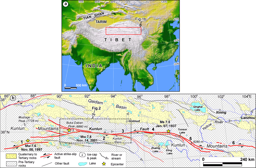
(a) Shaded-relief image of the India-Asia collision zone, generated from the USGS Shuttle Radar Topography Mission DEMs. (b) Fault segmentation of the Kunlun fault system between 86ー to 104ー E. The numbers 1-6 represent the Manyi, Kusai Lake, Xidatan-Dongdatan, Tuosuo Lake, Maqen, and Min Shan faults, respectively. The epicenter of the 2001 Kunlun earthquake was determined by the U.S. Geological Survey (USGS).
Fig. 2.
拡大する
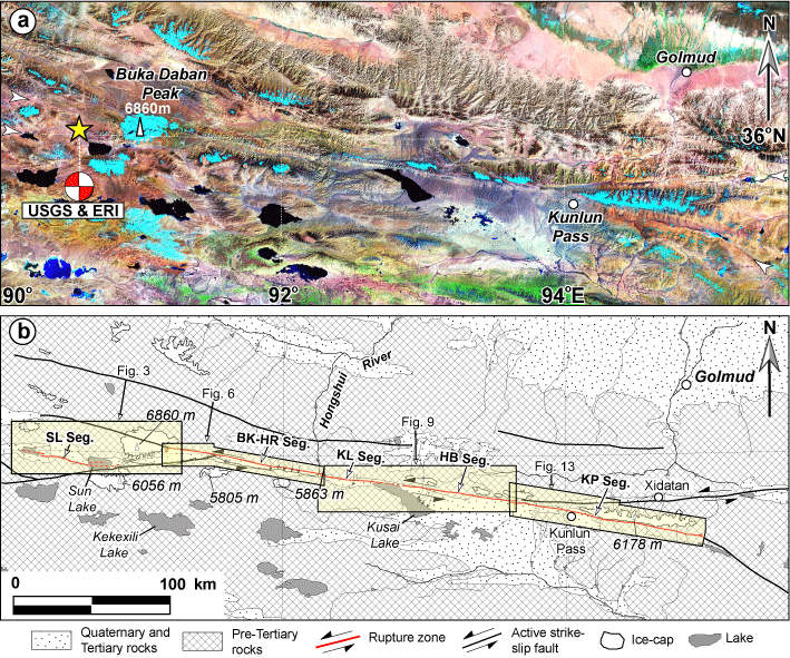
(a) Landsat ETM mosaic image of the Kusai Lake and Kunlun Pass faults of the Kunlun fault system. Fault traces indicated by arrows. The epicenter and focal mechanism of the 2001 Mw 7.8 Kunlun earthquake were determined by the USGS and Earthquake Research Institute (ERI) of the University of Tokyo, respectively. (b) Spatial distribution of the surface rupture zone produced by the 2001 Kunlun earthquake (Modified after Fu and Lin, 2003). SL Seg.: Sun Lake segment; BK-HR Seg.: Buka Daban-Hongshui River segment; KL Seg.: Kusai Lake segment; HB Seg.: Hubei Peak segment; KP Seg.: Kunlun Pass segment.
Fig. 3.
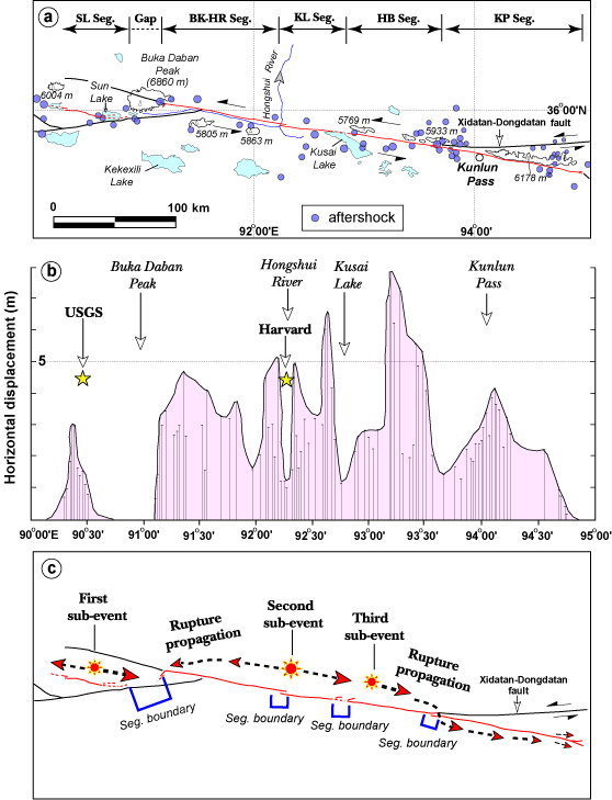
(a) Geometry and segmentation of the surface rupture zone associated with the 2001 large seismic event. The distribution of major aftershocks (ML>3.0) occurred during 14 November 2001 and 27 November 2001 (modified from Xu and Chen, 2004). (b) Slip distribution along the surface rupture zone, compiled from our field measurements and previous published results (CSB, 2002; Zhao et al., 2002). Locations of three major sub-events are same with the USGS`s epicenter, Harvard Moment Centriod, and third sub-event suggested by Xu and Chen (2004), respectively. (c) Rupture propagation model showing a complex multiple rupture process related to the 2001 seismic event.