活断層・古地震研究報告 第3号 トップへ
活断層情報を用いた想定地震の不均質すべり・応力分布の推定
関口春子・加瀬祐子・堀川晴央・石山達也・佐竹健治・杉山雄一
活断層研究センターでは、阪神地域と大阪湾を中心とする大阪堆積盆地をモデル地域として、地質学的情報を取り入れた地震動予測手法の開発を行っている。地下構造調査結果を基に作られた最新の3次元地下構造モデルと、活断層調査結果および破壊シミュレーションに基づく地震シナリオを取り入れ、地震動予測の性能を左右する要素を精度よく推定することを目指している。本稿では、活断層沿いで測定された過去の地震による変位の分布から、不均質な破壊を持つ地震シナリオを推定する方法を提案し、上町断層系への適用例を示す。
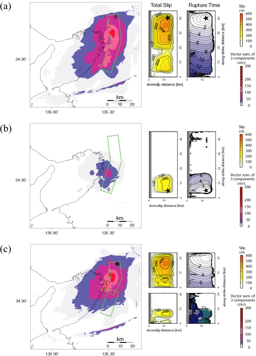
第1図
第1図. (左) 上町断層系の地表トレース (水野ほか、2002) と、上町断層系の累積変位に関するデータが得られたボーリング地点 (○)、反射法地震探査測線と上町断層系との交点 (□)、段丘面 (△)。(中) 左図に示した調査地点における平均上下変位速度 (記号は左図と同様。その色が累積変位の計算に用いた鍵層や段丘面の年代を示す) と大阪堆積盆地3次元地下構造モデルの堆積層中のMa3層下限の深度差から求めた平均変位速度の分布 (灰色線)。後者の見積もりには、単一セグメントの場合を仮定して、断層系に沿う変形域全体のMa3層の深度差を取っている。(右) 中図と同様。ただし、断層面が2つのセグメントに分かれていると考えて、それぞれのセグメントの地表トレースに沿って、平均上下変位速度を見積もった場合。2つのセグメントが重複している部分以外でも、中図の値と異なっている部分がある (例えば、南北軸の10~17 km付近など) が、これは、断層の地表トレースから離れた部分の地層の変位の中に、中図の見積もりには含まれていて、右図の見積もりには含まれていないものがあるためである。
Fig. 1. Left: Surface trace of the Uemachi fault system (bold line) and location of the borings, seismic reflection surveys and displaced Pleistocene terraces. Middle: Spatial variation of the average uplift rate across the whole deformation zone of the Uemachi fault system deduced from difference of depth of Ma3 layer (gray line). Circles, rectangles, and triangles indicate data of average uplift rate deduced from boring, seismic reflection survey and vertical offset of terrace surfaces, respectively. Right: The same as the middle frame, but assuming that the fault plane is divided into two segments and the average uplift rate is traced along each segment. The difference of the average uplift rate outside the overlapping of the two segments, e.g., in the range from 10 to 17 km along the north-south axis, between the middle and the right frames is due to the deformations off the traces, which are included in the middle frame but excluded from the right frame for the estimation of average uplift rate.
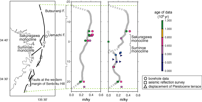
第2図
第2図. 上町断層系の破壊シナリオとそれから計算される地動速度の3成分ベクトル和の最大値の分布。(a) 上町断層系を単一セグメントとし、断層北端近くの静的応力降下量分布のピークから破壊を開始させた場合。(b) 上町断層系を単一セグメントとし、断層南端近くの静的応力降下量分布のピークから破壊を開始させた場合。(c) 上町断層系を2つのセグメントからなるとし、断層北端近くの静的応力降下量分布のピークから破壊を開始させた場合。
Fig. 2. Total slip and rupture time distributions of rupture scenarios and the peak ground velocity (vector summation of three components) distribution from the rupture scenarios in the three dimensional Osaka sedimentary basin structure model. (a) The case when the fault plane is a single segment and a hypocenter (star) is assumed near the northern margin of the fault system. (b) The case when the fault plane is a single segment and a hypocenter is assumed near the southern margin of the fault system. (c) The case when the fault plane consists of two segments and a hypocenter is assumed near the northern margin of the fault system.