活断層・古地震研究報告 第3号 トップへ
Coseismic surface deformation and engineering damage associated with the large strike-slip faulting: Lessons from the 2001 Mw 7.8 Central Kunlun earthquake
Bihong Fu, Yasuo Awata, Ken-ichi Kano, Aiming Lin and Eikichi Tsukuda
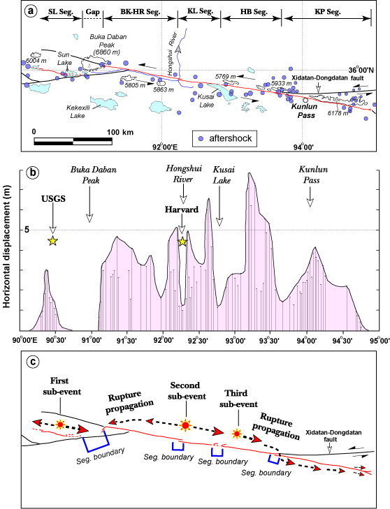
We analyzed coseismic surface deformations associated with the 2001 Mw 7.8 Central Kunlun earthquake, which occurred on 14 November 2001 along the west (Kusai Lake) segment of the left-lateral strike-slip Kunlun fault in northern Tibet, China. Field investigations and analyses of satellite remote sensing imagery indicate that a 400-km-long coseismic rupture zone occurred along the pre-existing Kunlun fault zone (Fig.1). The coseismic surface rupture zone is mainly composed of sinistral shear faults, tensional cracks, mole tracks (Fig.2), and pull-apart sag ponds and grabens. Width of the coseismic surface rupture zone ranges from several meters to 1 km. This earthquake caused damage to the highway between Golmud and Lhasa, base of the Qinghai-Tibet railway, and temporary housing for railway construction workers (Fig.3). It also triggered snow and glacier avalanches. The analyses of coseismic surface deformational features and engineering damage provide us useful experience to evaluate possible engineering damage associated with future great earthquakes on strike-slip faults in highly populated and industrialized regions. Furthermore, it also provides us an unusual opportunity to understand the growth of geomorphic features due to repeated large seismic events along an active strike-slip fault.
Fig. 1.
Fig. 1. (a) Landsat ETM/TM mosaic image of the Kusai Lake segment, Kunlun fault system (indicated by red arrows) in northern Tibet. The location of epicenter (indicated by a yellow star) of the 2001 Mw 7.8 Central Kunlun earthquake was determined by U.S. Geological Survey, and the focal mechanism solution was given by the Earthquake Research Institute, University of Tokyo. ATF: Altyn Tagh Fault, HYF: Haiyuan Fault, KLF: Kunlun Fault in index map. (b) Spatial distribution of the surface rupture zone produced by the 2001 Central Kunlun earthquake. Modified from Fu and Lin (2003).
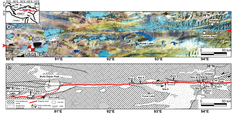
Fig. 2.
Fig. 2. Typical mole tracks (push-ups) along the Kunlun rupture zone. (a) Push-up structure (maximum height is 3.5 m) on the frozen surface of Kushuiwan Lake at Site 1. (b) Mole track (maximum height is 3.0 m) at Site 2, west of Sun Lake. (c) Mole track (maximum height is1.8 m) at Site 7. Locations of Sites 1, 2 and 7 are shown in Fig. 1b.
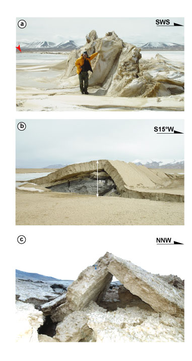
Fig. 3.
Fig. 3. Walls collapsed during the 2001 Central Kunlun earthquake. (a) A wall fell down toward NNE. Near Xidatan. (b) A wall toppled down toward SSW. 45 km southwest of the Kunlun Pass. Red arrows indicate the direction of collapse.