活断層・古地震研究報告 第2号 トップへ
北海道東部における完新世後期の急激な海岸隆起の繰り返し
Harvey Kelsey・佐竹健治・澤井祐紀・Brian Sherrod・下川浩一・宍倉正展
北海道東部の太平洋沿岸における層序 (第1図)・微地形の調査から、過去2800年間に急激な海岸隆起が7回発生したことが明らかになった。この地殻変動イベントは、七山ほか (2000) によって発見された津波堆積物と対比され、その繰り返し間隔はおよそ400年である (第2図)。海岸隆起と異常な津波は、通常のプレート間地震では説明できない。プレート間地震の後に、地震発生帯より深部が数ヶ月〜数年かけてゆっくりすべった可能性が高い (第3図)。
第1図
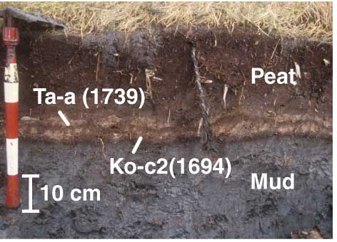
第1図. 浜中町火散布沼湖畔における泥層から泥炭層への層相の変化。
17世紀の噴火による2枚の火山灰層も見える。
Fig. 1. Typical contact of mud and peat layers, with two tephra layers. Observed on the Hichirippu lakeside.
第2図
第2図. 北海道東部の海岸付近の湿原 (位置図) で得られた試料の柱状図。これらの試料の層序には、泥層または泥炭質泥層から泥炭層への急激な層相の変化が記録されており、この層相の変化は急激な地殻変動によると考え、イベントの対比を行なった。
Fig. 2. Cores from coastal wetland sites in eastern Hokkaido (the locations are shown in Fig. 1). The lithostratigraphy in these cores record abrupt changes from mud or peaty mud upwards to peat. We infer that these abrupt changes record abrupt crustal deformation and correlate such events along the 100 km-long-coast.
第3図
第3図. (左) 根室市別当賀における現成及び隆起した浜堤の位置、柱状試料を採取した地点を示す。 (右) 海岸から2列の浜堤を横切り、後背湿地への断面図。隆起した海岸と浜堤上では、17世紀の火山灰層が保存されていることから、その降下直前に隆起したと考えられる。
Fig. 3. (Left) Map of Bettoga coastal lowland showing location of modern and raised beach storm berm, and location of core sites 1, 2, 3 and BT. (Right) Profile across modern beach and lower part of Bettoga lowland showing relative height of the two storm berms and the raised beaches. The raised beach and raised berm were deposited shortly before eruption of Ko-c2 tephra (A. D. 1694).
位置図