Bulletin of the Geological Survey of Japan Top Page
Bulletin of the Geological Survey of Japan Vol.73 No.5/6 (2022)
Special issue on marine geology around Tokara Islands in Kagoshima Prefecture: result of marine geological mapping survey cruse in 2020
Cover photograph | Table of Contents | Abstract
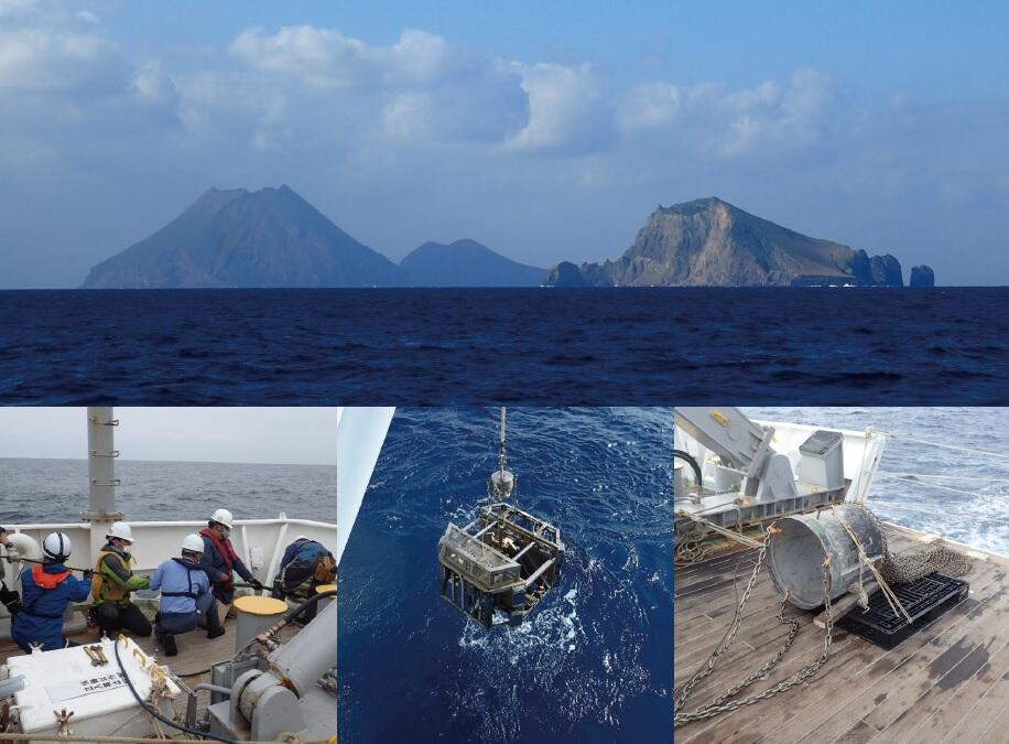
Cover photograph
Marine geological survey around Tokara Islands, Kagoshima Prefecture
The Geological Survey of Japan (GSJ) has been publishing the Marine Geology Map Series for the basic information of the national sea area around Japan since the 1970s. In this special issue, we report the results of seismic reflection profiling, bathymetry, magnetic anomaly and submarine sediment surveys conducted around the Tokara Islands as part of the northern Okinawa Trough Project.
Upper: Yokoatejima Island and Kaminonejima Island, volcanic islands in the Tokara Islands, Kagoshima Prefecture.
Kaminonejima Island is at the right front, and Yokoatejima Island is at the back left.
Lower left: Deploying the multi-channel streamer cable used for seismic profiling
Lower center: Grab sampler for retrieving submarine samples from the sea bottom
Lower right: Dredge sampler for retrieving rock samples
(Photograph and caption by INOUE Takahiko)
Table of Contents
All the pages PDF : 73_05_full.pdf [51MB]
| Title | Author | |
|---|---|---|
| Preface | ||
| Special issue on marine geology around Tokara Islands in Kagoshima Prefecture: result of marine geological mapping survey cruse in 2020 | INOUE Takahiko, AMANO Atsuko and ITAKI Takuya | 73_05_01.pdf [3.6MB] |
| Article | ||
| The bathymetry survey around Tokara Islands during GB21-1 and GK20 cruises | KOGE Hiroaki, SATO Taichi, YOKOYAMA Yuka, SATO Yusuke and MISAWA Ayanori | 73_05_02.pdf [8.3MB] |
| Preliminary results of the magnetic anomaly survey around Tokara Islands during the GB21-1 and GK20 cruises | KOGE Hiroaki, SATO Taichi, YOKOYAMA Yuka, SATO Yusuke and MISAWA Ayanori | 73_05_03.pdf [6MB] |
| Report | ||
| Seismic survey of GB21-1 Cruise off southwest Tokara Islands | ISHINO Saki, MISAWA Ayanori, ARIMOTO Jun and INOUE Takahiko | 73_05_04.pdf [7.7MB] |
| Shallow submarine structure around Tokara Islands based on the high-resolution subbottom profiler survey during the GK20 cruise | MISAWA Ayanori and SUZUKI Yoshiaki | 73_05_05.pdf [15MB] |
| Note and Comment | ||
| Submarine rock samples recovered during GB21-1 cruise in the southern Tokara Islands area | ISHIZUKA Osamu, ISHINO Saki, SUZUKI Yoshiaki, YOKOYAMA Yuka, MISAWA Ayanori, ARIMOTO Jun, KOGE Hiroaki and INOUE Takahiko | 73_05_06.pdf [8.2MB] |
| Report | ||
| Depositional ages of sediment and sedimentary rock samples obtained from the seafloor around the Tokara Islands during GB21-1 cruise, based on calcareous microfossil assemblages | ARIMOTO Jun and UTSUNOMIYA Masayuki | 73_05_07.pdf [4.3MB] |
| Article | ||
| Submarine sediment distribution and its controlling factors around the Takarajima Island and the Suwanosejima Island | SUZUKI Yoshiaki, ITAKI Takuya, KATAYAMA Hajime, KANEKO Naotomo, YAMASAKI Makoto, TOKUDA Yuki and SENTOKU Asuka | 73_05_08.pdf [7.5MB] |
| Report | ||
| Oceanographic environments around Takarajima Island and Suwanosejima Island | ITAKI Takuya, SUZUKI Yoshiaki, IKEUCHI Eri, OIKAWA Kazuma, KATAYAMA Hajime, IIZUKA Mutsumi, SUZUKI Atsushi and TAKAYANAGI Hideko | 73_05_09.pdf [5MB] |
| Article | ||
| Export and dispersal of coastal macrophyte-derived organic matter to deep offshore sediment around the Tokara and Yaeyama Islands, southwest Japan: Evaluation using quantitative DNA probing techniques |
MIYAJIMA Toshihiro, HAMAGUCHI Masami, NAKAMURA Takashi, KATAYAMA Hajime and HORI Masakazu | 73_05_10.pdf [1.5MB] |
| Report | ||
| Microbial community structure of surface sediments in the deep-sea area around the Tokara Islands, Japan | IKEUCHI Eri, SUZUKI Yoshiaki, IGUCHI Akira and SUZUKI Atsushi | 73_05_11.pdf [1.3MB] |
| Preliminary report of recent ostracode assemblages from the adjacent sea of Tokara Gap | NAKANO Taiga, IWATANI Hokuto, SUZUKI Yoshiaki, ITAKI Takuya, KUBO Nozomi and SASAKI Satoshi | 73_05_12.pdf [1MB] |
| Chemical composition of marine surface sediments around Tokara Islands (GB21-1 Cruise), Japan | KUBOTA Ran, OHTA Atsuyuki, TACHIBANA Yoshiko, ITAKI Takuya, KATAYAMA Hajime, SUZUKI Yoshiaki and MANAKA Mitsuo | 73_05_13.pdf [1MB] |
Abstract
The bathymetry survey around Tokara Islands during GB21-1 and GK20 cruises
KOGE Hiroaki, SATO Taichi, YOKOYAMA Yuka, SATO Yusuke and MISAWA Ayanori
The high–resolution seafloor bathymetry was observed using Multibeam acoustic profiler (MBES) as a part of an ongoing geological mapping of the southern region of the Tokara Islands region. As a result, intricated two lineations (N24°E and N73°E) were observed in this area. The structures could be related to the formation of the Okinawa Trough and Tokara Gap, respectively. From the cutting relationship, we considered that the gap formation occurred after the trough expansion. In addition, we discovered a group of knoll chains in the N73°E direction in the southern part of the Yokogan Knoll, which we named and described as the Yokoate Echelon Knoll Chains. Based on the dipole–type magnetic anomalies and seismic reflection survey results, the Yokoate Echelon Knoll Chains are inferred to be volcanic structures. Therefore, these linear structures should be related to the rifting of the Okinawa Trough and the formation of the Tokara Gap, and this area might to be important for understanding the history of the back–arc rifting in the northern Ryukyu Arc.
Preliminary results of the magnetic anomaly survey around Tokara Islands during the GB21-1 and GK20 cruises
KOGE Hiroaki, SATO Taichi, YOKOYAMA Yuka, SATO Yusuke and MISAWA Ayanori
The magnetic observation was observed using shipboard three–component magnetometer (STCM) as a part of an ongoing geological mapping of the southern region of the Tokara Islands region. In this cruise, we used the data of the STCM for the calculation instead of the cesium magnetometer. We tried to conduct the corrections with the existing data Magnetic Anomaly Map of East Asia (CCOP 3rd). As a result, because the data observed by the STCM was very accurate, and the total magnetic anomaly analyzed by this method was almost the same accurate as the cesium magnetometer, and was free from errors at the intersections that usually appear. Therefore, this correction method could improve to also the observation of cesium magnetometers. In the island arc area, many dipole–type magnetic anomalies were observed. With bathymetrical observation, it suggests active volcanism. On the other hand, the trench side was almost flat magnetically. On the trough side, the significant positive magnetic anomalies were observed. This area has a small knoll, but it is not so distinct, which might reflect large–scale igneous activity beneath the seafloor that is not currently visible on land.
Seismic survey of GB21-1 Cruise off southwest Tokara Islands
ISHINO Saki, MISAWA Ayanori, ARIMOTO Jun and INOUE Takahiko
A multi-channel seismic survey was conducted off southwest Tokara Islands by GB21-1 survey cruise for marine geological maps. The seismic stratigraphy and geological structures were compiled with reflection profiles, which were obtained by high-density spacing survey. West of the volcanic front is characterized by four sedimentary units (OT1–OT4) divided by unconformities. The faults found in the west of the volcanic front were divided into two types: normal faults affecting vertical displacement in the OT1 unit and affecting cumulative vertical displacement in the OT3 unit sediment layers. The former faults were recognized east of Nishi-Yokoate Knoll with NNE–SSW trending. The later faults are developed widely west of the volcanic front, and found with NE–SW trending along the east edge of Okinawa Trough and with ENE–SWS trending southwest of Takarajima island. The normal faults affecting cumulative vertical displacement in the OT3 unit are considered to be formed by intermittent NW–SE extension related to the back-arc rifting in the northern Okinawa Trough after formation of the OT2 unit. In the east of volcanic front, the sedimentary units are divided into four (TK1–TK4) based on unconformities and acoustic facies differences. Two types of faults were found in the east of the volcanic front: normal faults that trend E-W and affect cumulative vertical displacement in the TK4 unit sediment layers in the northern margin of the Amami Trough, and normal faults that trend WNW–ESE and cause vertical displacement through the TK3 and TK4 units in the southeast of Takarajima Island. Combining fault characteristics based on seismic stratigraphy with analysis of sedimentary age will provide further discussions on tectonics in the northern Ryukyu Arc.
Shallow submarine structure around Tokara Islands based on the high-resolution subbottom profiler survey during the GK20 cruise
MISAWA Ayanori and SUZUKI Yoshiaki
The GK20 cruise was conducted using the research vessel Kaiyo-Maru No.2 (Kaiyo Engineering Co., Ltd.) around the Tokara Islands area from early November to early December in 2020. In this cruise, a high-resolution subbottom profiler (SBP) survey was conducted to clarify the shallow submarine structure in the Okinawa Trough, the Volcanic front area, and the Ryukyu Arc area around the Tokara Islands. This paper reports on the shallow geological structures around the Tokara Islands as revealed by SBP profiles. In the Okinawa Trough area, the structure of well-stratified trough-fill sediments of the Okinawa Trough and the development of normal faults were confirmed. The bathymetric features of the volcanic front area can be roughly divided into islands or topographic high and flat plains. The internal structure of the islands and the topographic high was unclear, but there was a well-stratified sedimentary layer on the flat plain. On the flat surface located on the south side of the Takarajima Island, the development of the Yokoate Echelon Knoll Chains, six slanting lines organized by submarine volcanoes, was identified. In the Ryukyu Arc area, sand wave-like faces were recognized on the northern rim of the Oshima-Shin Sone. In the Amami Trough, the well-stratified sedimentary beds and the graben bounded by the normal fault were identified.
Submarine rock samples recovered during GB21-1 cruise in the southern Tokara Islands area
ISHIZUKA Osamu, ISHINO Saki, SUZUKI Yoshiaki, YOKOYAMA Yuka, MISAWA Ayanori, ARIMOTO Jun, KOGE Hiroaki and INOUE Takahiko
Dredge sampling to recover submarine rocks was conducted in the southern Tokara Islands area as part of an ongoing geological mapping campaign for the region. The sampling targets were submarine volcanoes found by bathymetric survey, and sedimentary rock units revealed by seismic reflection survey. Dredge sampling at 2 volcanic edifices mainly recovered rhyolitic pumice and lava, and basaltic spatter. Sampling along the major fault scarps recovered mudstone containing microfossils, which are useful for age determination of the rocks. Whole rock chemical compositions of basalts recovered from the edifice near the volcanic front of the Ryukyu Arc show similar alkali metal element concentrations to the basalts from the front. Rhyolites from the edifice in the Okinawa Trough show higher alkali metal element concentrations than those from the frontal arc volcanoes.
Depositional ages of sediment and sedimentary rock samples obtained from the seafloor around the Tokara Islands during GB21-1 cruise, based on calcareous microfossil assemblages
ARIMOTO Jun and UTSUNOMIYA Masayuki
Calcareous nannofossil and planktic foraminiferal assemblages were examined to determine the depositional ages for some seafloor sediments and sedimentary rock samples obtained during GB21-1 cruise at around the Tokara Islands, northern Ryukyu arc. Seven samples from three localities, one in the forearc side and two in the back-arc, were prepared for biostratigraphic study.Unconsolidated and partially consolidated muddy samples from the back-arc sites represent the depositional age younger than Middle Pleistocene (0–0.29 Ma). On the other hand, the depositional age of latest Early to Middle Pleistocene is indicated for calcareous microfossil assemblages in the sedimentary rocks dredged at both forearc and back-arc sites, most likely constrained from 0.9 or 0.8 Ma to 0.43 Ma.
Submarine sediment distribution and its controlling factors around the Takarajima Island and the Suwanosejima Island
SUZUKI Yoshiaki, ITAKI Takuya, KATAYAMA Hajime, KANEKO Naotomo, YAMASAKI Makoto, TOKUDA Yuki and SENTOKU Asuka
As part of geological survey cruise GB21-1 around the southern area off the Tokara Islands, we conducted surface sediment sampling at 61 sites and sediment core sampling at 2 sites. Muddy sediments subjected to strong biological disturbance were found at depths of 800 m or more. Core sample analysis revealed that this biological disturbance extended to at least 2 m below the seafloor. The distribution of sandy sediments, gravel and outcrops were not necessarily limited by water depth. Rather, sediment distribution appeared to be influenced by the existence of submarine volcanoes, which can act as sources of sediment under the seafloor, in addition to sediment from islands in the region. Bedforms such as ripples, local concentrations of biological remains, and the distribution of outcrops and gravel deposits, which were frequently observed around Takarajima Island, suggest that the meandering Kuroshio Current has a marked effect on sediments in the area. To the southwest of Suwanosejima Island, muddy deposits were found below a rippled volcanic ash sand layer. Based on assessments of sediment particle size and composition, it is possible that these muddy sediments were deposited by geological event(s), such as slope failure from Suwanosejima Island.
Oceanographic environments around Takarajima Island and Suwanosejima Island
ITAKI Takuya, SUZUKI Yoshiaki, IKEUCHI Eri, OIKAWA Kazuma, KATAYAMA Hajime, IIZUKA Mutsumi, SUZUKI Atsushi and TAKAYANAGI Hideko
CTD observations and bottom water samplings were conducted at a total of 61 sites in the waters surrounding the Tokara Islands during GB21-1 cruise (February 28 to March 30, 2021). The survey area is located in the pathway where the Kuroshio Current flows out from the East China Sea to the Philippine Sea, and is divided into the Kuroshio water, North Pacific Subtropical Mode Water, North Pacific Intermediate Water, and North Pacific Deep Water from the surface to the bottom. The surface layer around Yokoatejima Island is characterized by low temperature and high salinity, which is thought to be the effect of vertical mixing caused by topographic high. Off the east coast of Takarajima Island, a high turbidity layer with several tens of meters thick is observed near the seafloor, which is thought to be caused by sediment suspension due to currents on the seafloor.
Export and dispersal of coastal macrophyte-derived organic matter to deep offshore sediment around the Tokara and Yaeyama Islands, southwest Japan: Evaluation using quantitative DNA probing techniques
MIYAJIMA Toshihiro, HAMAGUCHI Masami, NAKAMURA Takashi, KATAYAMA Hajime and HORI Masakazu
Vegetated coastal habitats such as seagrass meadows, macroalgal beds, and mangroves export large amounts of organic carbon (OC) to offshore regions. The exported OC may be consumed as a food source by various pelagic and benthic organisms, enhancing secondary production, or may settle and be buried in offshore sediment, contributing to carbon sequestration. Hence, OC export is an important ecosystem service of coastal wetlands supporting connectivity from coastal to offshore habitats. We studied the dispersal of detrital organic matter derived from coastal macrophytes to offshore sediment around the Tokara and Yaeyama Islands (subtropical western North Pacific) using DNA probing techniques and compared the results with the bulk OC concentration and granulometric properties of the sediment. The results showed that dispersal of macrophyte detritus was constrained hydrographically by the strong Kuroshio current flowing near the study areas. Mangrove- and seagrass-derived organic matter exported from coastal habitats of the Yaeyama Islands was detected around the Yaeyama Islands and accumulated in deep-basin sediments (>1000 m) of the southern Okinawa Trough; however, its dispersal seemed to be confined by the Kuroshio. By contrast, sediments around the Tokara Islands often contained macroalgal materials that were rarely found in those around Yaeyama Islands. Most of the macroalgal organic matter found in the sediments of the Tokara area likely originated in coastal habitats of continental China and was transported by the Kuroshio across the shelf of the East China Sea to the northern Okinawa Trough, where it was trapped within sediment. The bulk OC concentrations in the sediment of both areas were constrained by the granulometric properties of the sediment, such as specific surface area. However, the abundance of macrophyte-derived organic matter did not correlate with the concentration or stable isotope ratio of the bulk-sediment OC, implying that macrophyte OC represents a minor fraction of the bulk OC stored in the sediment of the study areas.
Microbial community structure of surface sediments in the deep-sea area around the Tokara Islands, Japan
IKEUCHI Eri, SUZUKI Yoshiaki, IGUCHI Akira and SUZUKI Atsushi
To accumulate distribution information for microbes around Japan, we analyzed the microbial community in the surface sediments of the marine geological survey in the waters surrounding the Tokara Islands, Japan (GB21-1). DNA was successfully obtained from 42 of 47 samples collected, sequenced by high-throughput sequencer, and analyzed by R. The results of the analysis showed that many DNA sequences were identified as belonging to Gammaproteobacteria and Alphaproteobacteria of the phylum Proteobacteria, followed by Actinobacteria of the phylum Actinobacteriota. Microbial community structure tends to be grouped according to the depth zone and the type of substrate. It may be possible to compare geographical differences in microbial communities by increasing the number of sites.This study is the first comprehensive and quantitative assessment of the microbial community structure in the Tokara Islands and is expected to be used as basic information for future understanding of deep-sea communities and environmental impact assessment.
Preliminary report of recent ostracode assemblages from the adjacent sea of Tokara Gap
NAKANO Taiga, IWATANI Hokuto, SUZUKI Yoshiaki, ITAKI Takuya, KUBO Nozomi and SASAKI Satoshi
We studied the spatial distribution of the recent ostracode in the adjacent sea of Takarajima Island, Japan. This is the first study to report the recent ostracode assemblages in the study area. We examined the ostracode faunal composition in 5 surface sediments collected by GB21-1 cruise (AIST). As a result, at least 60 ostracode taxa were identified. Most of the assemblages were subtropical and tropical water species that have been reported from the East China Sea. Three ostracode bioassociations and two biofacies were discriminated based on R-mode and Q-mode cluster analyses. Ostracode bioassociations and biofacies were correlated with the water depth and the mud content. Thus, it is likely that recent ostracode assemblages in the adjacent sea of Takarajima Island were affected by surface sediment variations accompanied by water depth changes.
Chemical composition of marine surface sediments around Tokara Islands (GB21-1 Cruise), Japan
KUBOTA Ran, OHTA Atsuyuki, TACHIBANA Yoshiko, ITAKI Takuya, KATAYAMA Hajime, SUZUKI Yoshiaki and MANAKA Mitsuo
The concentrations of 24 elements in the 56 marine surface sediment samples collected from around Tokara Islands, were determined, and the characteristics of the chemical composition and concentration distribution were investigated. The sediments in this sea area are rich in T-Fe2O3 (converted total iron concentration to Fe2O3), MgO and MnO, and the CaO concentration is relatively low, suggesting that the contribution of terrigenous clastic materials is greater than that of bioclasts. The analysis results of the relationship between the Al2O3 content and the CaO, K2O, and T-Fe2O3 contents revealed that the contribution of terrigenous clastic materials is large in the shallow-water areas around Suwanosejima Island and Takarajima Island. The considerable enrichment of Mn, Ni, Cu, Zn, and Pb in silt-clay samples in the off western Takarajima Island, can be assumed to be due mainly to adsorption to particle surface by the early diagenesis.
Geological Survey of Japan, AIST
- About GSJ
- Our Activities
- Purchase guide
-
Publications and Database
- information
-
Bulletin of the Geological Survey of Japan
- bull2026(Vol.77)
- bull2025(Vol.76)
- bull2024(Vol.75)
- bull2023(Vol.74)
- bull2022(Vol.73)
- bull2021(Vol.72)
- bull2020(Vol.71)
- bull2019(Vol.70)
- bull2018(Vol.69)
- bull2017(Vol.68)
- bull2016(Vol.67)
- bull2015(Vol.66)
- bull2014(Vol.65)
- bull2013(Vol.64)
- bull2012(Vol.63)
- bull2011(Vol.62)
- bull2010(Vol.61)
- bull2009(Vol.60)
- bull2008(Vol.59)
- bull2007(Vol.58)
- bull2006(Vol.57)
- bull2005(Vol.56)
- bull2004(Vol.55)
- bull2003(Vol.54)
- bull2002(Vol.53)
- bull2001(Vol.52)
- Bulletin of the Geological Survey of Japan(old)
- Annual Report on Active Fault and Paleoearthquake Researches
- Reports, Geological Survey of Japan
- CCOP-GSJ Groundwater Project Report
- CCOP Technical Bulletin
- Cruise Report
- Geological Hazards
- Learning and Education
- GSJ Database Collection
- Collection of links