Bulletin of the Geological Survey of Japan Top Page
Bulletin of the Geological Survey of Japan Vol.73 No.2 (2022)
Cover photograph | Table of Contents | Abstract
Cover photograph
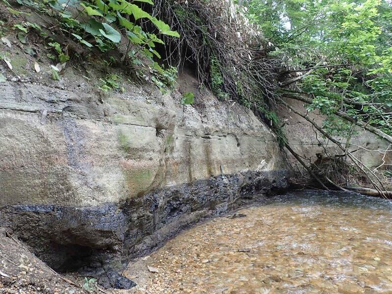
Chibanian tephra distributed in the Sotoyama Plateau, Kitakami Massif
The Sotoyama Plateau, which undulates gently from 650 to 1,000 m, is located in northeastern Morioka City, Iwate Prefecture. In the Sotoyama River, which drains the plateau, a tephra layer with a thickness of 80 cm is exposed above a >1 m-thick peat layer for a distance of approximately 100 m. Despite being adjacent to a national highway, this exposed tephra layer has not been reported previously. The tephra was named the Yabukawa Tephra by Uchino et al. (2022) in this issue, and their zircon dating dated the tephra to the late Chibanian. The horizontal holes visible in the tephra layer shown in the photo are nesting burrows constructed by Brown dippers.
(Photograph and Caption by UCHINO Takayuki)
Table of Contents
All the pages PDF : 73_02_full.pdf [20MB]
| Title | Author | |
|---|---|---|
| Article | ||
| Preparation and release of gravity data collected by R/V Hakurei-maru No.2 | ISHIHARA Takemi and ODA Hirokuni (p29-48) | 73_02_01.pdf [6MB] |
| Fossil foraminiferal and ostracode assemblages from the Pleistocene Tokyo Formation in cores GS-SE-1, Kami-Yoga and GS-SE-3, Komazawa, Setagaya, Tokyo, central Japan | KANEKO Minoru, ISHIKAWA Hiroyuki, HARASHIMA Mai, NOMURA Masahiro and NAKAZAWA Tsutomu (p49-65) | 73_02_02.pdf[6.5MB] |
| Report | ||
| Late Chibanian tephra recognized in the Sotoyama Plateau of Yabukawa area in Morioka City, Iwate Prefecture, mid-western Kitakami Massif | UCHINO Takayuki, KUDO Takashi, FURUSAWA Akira, IWANO Hideki, DANHARA Toru and KOMATSUBARA Taku (p67-85) | 73_02_03.pdf [18MB] |
| Measurement of non-methane hydrocarbon in water by purge and trap method and water flow method: calculation of total concentration based on data obtained using water flow method | IGARI Shunichiro (p87-92) | 73_02_04.pdf[676KMB] |
Abstract
Preparation and release of gravity data collected by R/V Hakurei-maru No.2
ISHIHARA Takemi and ODA Hirokuni
One-minute interval high-quality gravity data were prepared for the Hakurei-maru No.2 cruises carried out by Geological Survey of Japan from 2000 to 2010. An 8-th order Butterworth low-pass filter with the cutoff frequency of 1/480 Hz (period of 8 minutes) was applied to 1 Hz gravity raw data to make high-resolution free air anomaly data. The RMS CODs (root mean square crossover differences) of the gravity data for the intersecting survey lines are 0.86 mGal for GH00 and GH01 cruises, 1.02 mGal for GH02, GH03, GH04 and GH06 cruises, and 1.30 mGal for GH08, GH09 and GH10 cruises.
It is suggested that the following two factors are the possible sources of 3 to 5 mGal differences observed between the two free air anomalies obtained by Hakurei-maru No.2 and satellite altimetric data, i.e., 1) free air anomaly data collected by Hakurei-maru No.2 have short period anomalies which are not observed in the satellite altimetric data, and 2) the accuracy of altimetric data decreases near the coasts. The gravity data files, which include data after free air gravity anomaly calculation will be released as an open-file report of Geological Survey of Japan.
Fossil foraminiferal and ostracode assemblages from the Pleistocene Tokyo Formation in cores GS-SE-1, Kami-Yoga and GS-SE-3, Komazawa, Setagaya, Tokyo, central Japan
KANEKO Minoru, ISHIKAWA Hiroyuki, HARASHIMA Mai, NOMURA Masahiro and NAKAZAWA Tsutomu
Fossil assemblages of foraminifers and ostracodes were investigated in the Pleistocene Tokyo Formation, Shimosa Group, which is distributed beneath the Musashino Upland in Setagaya, southwestern Tokyo. Fossil foraminifers and ostracodes were collected from two sediment cores: GSSE-1, Kami-Yoga and GS-SE-3, Komazawa, Setagaya, Tokyo. Thirty-eight samples were obtained from the approximately 25-m-thick Tokyo Formation in the cores for the analysis. Of them, 40 benthic foraminiferal species belonging to 18 genera were identified from 18 samples, and 41 ostracode species belonging to 21 genera were identified from 14 samples. Planktonic foraminifers were not detected. On the basis of the fossil foraminiferal and ostracode assemblages, the Tokyo Formation is subdivided into eight zones: Zones I–VI in the lower part and Zones VII and VIII in the upper part. They are interpreted as an inner bay environment in Zone I, a middle bay environment in Zone II–IV, an inner to middle bay environment in Zone V and an outer bay environment in Zone VI in ascending order. Zones VII and VIII, which correspond to the upper part of Tokyo Formation, are considered as an outer bay environment near a coastal area.
Late Chibanian tephra recognized in the Sotoyama Plateau of Yabukawaarea in Morioka City, Iwate Prefecture, mid-western Kitakami Massif
UCHINO Takayuki, KUDO Takashi, FURUSAWA Akira, IWANO Hideki, DANHARA Toru and KOMATSUBARA Taku
The Sotoyama Plateau on the mid-western Kitakami Massif, Northeast Japan, displays a low-relief surface with an altitude of 650–1000 m. This topography is considered to have been
formed by periglacial phenomena. We discovered the 80-cm-thick pyroclastic fall deposit, named Yabukawa Tephra in this study, from the Quaternary valley floor deposits along the Sotoyama River
on the plateau. This tephra is subdivided into four subunits on the basis of their lithofacies. The tephra contains characteristically large amounts of vesiculated pumice and minor lithic fragments: andesite, dacite, rhyolite, tuffaceous mudstone, tonalite, chert, etc. It also contains grains of beta-quartz, feldspar, hornblende, orthopyroxene, ilmenite, biotite, etc. A geochemical composition of volcanic glasses from the tephra shows relatively high SiO2 and K2O, and low CaO, MgO and TiO2. Their refraction indexes are 1.495–1.498.
The Yabukawa Tephra is thought to deposit in the late Chibanian on the basis of the 0.24 ± 0.04 Ma fission-track age from zircon in its pumice. Furthermore, the tephra is possibly correlated with the Odai White Volcanic Ash, which occurs in the eastern foot of Mt. Iwate, based on its petrography, refraction indexes of volcanic glasses and the zircon age.
Measurement of non-methane hydrocarbon in water by purge and trap method and water flow method: calculation of total concentration based on data obtained using water flow method
IGARI Shunichiro
At National Institute of Advanced Industrial Science and Technology (AIST), research has been conducted on changes in the concentration of non-methane hydrocarbon (NMHC) in tap water over time, and on the preparation of NMHC-free water. In these studies, the water flow method was used to measure the NMHC concentration. However, since this method detects only part of the NMHC in water, although it can be used for comparing water samples and observing changes in the NMHC content over time, it is not suitable for measuring the total NMHC concentration. In this study, we measured the NMHC concentration in water samples using both the water flow method and the purge and trap method, and compared the results. The findings showed that seven times the concentrations obtained by the water flow method approximate the total values.
Geological Survey of Japan, AIST
- About GSJ
- Our Activities
- Purchase guide
-
Publications and Database
- information
-
Bulletin of the Geological Survey of Japan
- bull2026(Vol.77)
- bull2025(Vol.76)
- bull2024(Vol.75)
- bull2023(Vol.74)
- bull2022(Vol.73)
- bull2021(Vol.72)
- bull2020(Vol.71)
- bull2019(Vol.70)
- bull2018(Vol.69)
- bull2017(Vol.68)
- bull2016(Vol.67)
- bull2015(Vol.66)
- bull2014(Vol.65)
- bull2013(Vol.64)
- bull2012(Vol.63)
- bull2011(Vol.62)
- bull2010(Vol.61)
- bull2009(Vol.60)
- bull2008(Vol.59)
- bull2007(Vol.58)
- bull2006(Vol.57)
- bull2005(Vol.56)
- bull2004(Vol.55)
- bull2003(Vol.54)
- bull2002(Vol.53)
- bull2001(Vol.52)
- Bulletin of the Geological Survey of Japan(old)
- Annual Report on Active Fault and Paleoearthquake Researches
- Reports, Geological Survey of Japan
- CCOP-GSJ Groundwater Project Report
- CCOP Technical Bulletin
- Cruise Report
- Geological Hazards
- Learning and Education
- GSJ Database Collection
- Collection of links