Bulletin of the Geological Survey of Japan Top Page
Bulletin of the Geological Survey of Japan Vol.71 No.5 (2020)
Cover photograph | Table of Contents | Abstract
Cover Photo
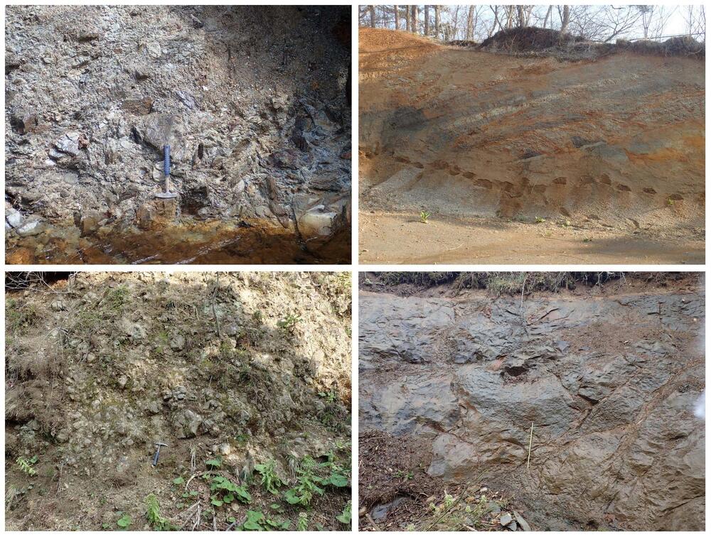
Outcrop photographs of the Lower to Middle Miocene in the eastern part of Shimokita Peninsula
The Lower to Middle Miocene sedimentary and volcanic rocks are widely distributed in the eastern part of
Shimokita Peninsula, northeastern Aomori Prefecture. These strata are terrestrial and shallow to deep marine
deposits from sedimentary basins that developed due to the subsidence associated with the opening of the Japan Sea.
Upper left: Basal breccia of the Sarugamori Formation exposed at the upstream of Noushi River in Higashidori Village. This breccia is a talus deposit that consists of mudstone and sandstone gravels derived from the Jurassic
basement rocks. The length of the hammer is 32 cm.
Upper right: Alternating beds of mudstone and sandstone of the Sarugamori Formation exposed at the northeast of
Otoge in Higashidori Village. These are shallow-marine deposits abundant in plant fragments. The height
of the outcrop is about 6 m.
Lower left: Subaqueous autobrecciated basaltic andesite lava of the Tomari Formation exposed at the upstream of
Okawa River in Higashidori Village. Jigsaw-fit fractures due to water-quench fragmentation are observed.
The length of the hammer is 32 cm.
Lower right: Massive diatomaceous mudstone of the Gamanosawa Formation exposed at the upstream of Aobera
River in Higashidori Village. This mudstone is a bathyal deposit abundant in microfossils. Scale length is 1 m.
(Photograph and caption by KUDO Takashi)
Table of Contents
All the pages PDF : 71_05_full.pdf [25MB]
| Title | Author | |
|---|---|---|
| Article | ||
| Chronostratigraphy of the Lower to Middle Miocene in the eastern part of Shimokita Peninsula, Northeast Japan | KUDO Takashi, HORIUCHI Seiji and YANAGISAWA Yukio (p439–462) | 71_05_01.pdf [9.5MB] |
| Report | ||
| Recognition and stratigraphic correlation of marine Pleistocene deposits beneath the Hidaka Upland based on diatom assemblages in the Hidaka Observation Well, Saitama Prefecture, Japan | NAYA Tomonori, NAGAI Masashi and OMURA Kentaro (p463–472) | 71_05_02.pdf [3MB] |
| A sediment core of Holocene incised valley fills in the Nahari Lowland, east Kochi Prefecture, southwest Japan | UEKI Takeyuki (p473–479) | 71_05_03.pdf [1MB] |
| Note and Comment | ||
| Zircon U–Pb and fission-track ages of the Miocene in the 1:200,000 Noheji Quadrangle, Northeast Japan | KUDO Takashi (p463–472) | 71_05_04.pdf [12MB] |
Abstract
Chronostratigraphy of the Lower to Middle Miocene in the eastern part of Shimokita Peninsula, Northeast Japan
KUDO Takashi, HORIUCHI Seiji and YANAGISAWA Yukio
Chronostratigraphy of the Lower to Middle Miocene Sarugamori, Takahoko, Tomari and Gamanosawa formations in the eastern part of Shimokita Peninsula, Northeast Japan was constructed based on geological survey and microfossil biostratigraphic analysis. The diatom zone NPD4Ba and the calcareous nannofossil zone CN4 are identified in the Gamanosawa Formation and the diatom zones NPD4A, NPD4Ba, NPD4Bb and the calcareous nannofossil zone CN5a are identified in the upper part of the Takahoko Formation. The age of each formation estimated from litho- and biostratography is as follows; Sarugamori Formation: between 17 Ma and 15 Ma, Takahoko Fomation: 16.6–13.1 Ma, Tomari Formation: 16.6–15 Ma, Gamanosawa Formation: 15–10 Ma. Biostratigraphy shows that most of the K–Ar ages reported from the Tomari Formation by previous studies are rejuvenated ages. The unconformity between the Tomari and Gamanosawa Formations around 15 Ma is correlated to the widespread unconformity recognized in the Miocene strata in the central and northeast Japan.
Recognition and stratigraphic correlation of marine Pleistocene deposits beneath the Hidaka Upland based on diatom assemblages in the Hidaka Observation Well, Saitama Prefecture, Japan
NAYA Tomonori, NAGAI Masashi and OMURA Kentaro
In order to investigate the presence of marine Pleistocene deposits under the Hidaka Upland, the western part of Kanto Plain, central Japan, diatom assemblages are analyzed using cuttings specimens obtained from the depth between 550 to 130 m of the Hidaka Observation Well drilled by National Research Institute for Earth Science and Disaster Resilience (NIED). Diatom fossils occur in the specimens ranging from the depth 130 to 200 m in the well. All diatom assemblages are dominated by marine to brackish species, suggesting that marine beds include shallow marine sediments. Since the fossil diatom Lancineis rectilatus, a biostratigraphic index species indicating 1.45 to 0.7 Ma in Kanto Plain, is not found from any specimens, shallow marine beds in the well can be correlated to below the L. rectilatus zone in the Kawajima core, 600 m-long core located at about 14 km away from the Hidaka Observation Well, and also correlated to the Lower Pleistocene Bushi Formation in the Kaji Hills.
A sediment core of Holocene incised valley fills in the Nahari Lowland, east Kochi Prefecture, southwest Japan
UEKI Takeyuki
Sediment core 42 m long was drilled in the Nahari Lowland, east Kochi Prefecture, southwest Japan. The core was composed entirely of gravelly deposits derived by the Nahari River. Radiocarbon (14C) ages from Latest Pleistocene to Early Holocene were obtained at four horizons. A Holocene incised valley fills more than 42 m thick underlie in the Nahari Lowland. Higher sedimentation rate of the incised valley fills corresponds to the Early Holocene transgression.
Zircon U–Pb and fission-track ages of the Miocene in the 1:200,000 Noheji Quadrangle, Northeast Japan
KUDO Takashi
Zircon U–Pb and fission track dating for the Miocene strata was carried out in the preparation of the geological map of Japan 1:200,000, Noheji (2nd edition). Seven volcanic and volcaniclastic rock samples from the Sunagomata, Gamanosawa, Tomari, Kozawa and Yotsuzawa formations were analyzed for dating. This report describes the geology of these sampling sites and dating results.
Geological Survey of Japan, AIST
- About GSJ
- Our Activities
- Purchase guide
-
Publications and Database
- information
-
Bulletin of the Geological Survey of Japan
- bull2026(Vol.77)
- bull2025(Vol.76)
- bull2024(Vol.75)
- bull2023(Vol.74)
- bull2022(Vol.73)
- bull2021(Vol.72)
- bull2020(Vol.71)
- bull2019(Vol.70)
- bull2018(Vol.69)
- bull2017(Vol.68)
- bull2016(Vol.67)
- bull2015(Vol.66)
- bull2014(Vol.65)
- bull2013(Vol.64)
- bull2012(Vol.63)
- bull2011(Vol.62)
- bull2010(Vol.61)
- bull2009(Vol.60)
- bull2008(Vol.59)
- bull2007(Vol.58)
- bull2006(Vol.57)
- bull2005(Vol.56)
- bull2004(Vol.55)
- bull2003(Vol.54)
- bull2002(Vol.53)
- bull2001(Vol.52)
- Bulletin of the Geological Survey of Japan(old)
- Annual Report on Active Fault and Paleoearthquake Researches
- Reports, Geological Survey of Japan
- CCOP-GSJ Groundwater Project Report
- CCOP Technical Bulletin
- Cruise Report
- Geological Hazards
- Learning and Education
- GSJ Database Collection
- Collection of links