Bulletin of the Geological Survey of Japan Top Page
Bulletin of the Geological Survey of Japan Vol.71 No.2 (2020)
Cover photograph | Table of Contents | Abstract
Cover photograph
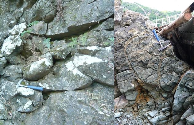
Overturned pillow lavas in the Mikabu Greenstones
Explanation: In the eastern Kii Peninsula, the Mikabu Greenstones, which belong to the Sambagawa Belt, are exposed for ca. 3 km from south to north and ca. 30 km from west to east. They are composed of basaltic lavas and volcaniclastic rocks with minor amounts of dolerite, gabbro and ultramafic rocks. The lavas frequently show overturned pillow structure, which is one of the reasons that support the existence of a large-scale recumbent fold within the Sambagawa Belt in this district. The mafic rocks are characterized by two types of amphiboles: igneous brown hornblende and metamorphic blue-purple alkali amphibole, the latter of which is reported in detail in this volume.
(Left) Hikogataki valley within the forest area of the Ise Grand Shrine, Ise City; (right) beach in northeastern Arashima area, Toba City.
(Photograph and Caption by UCHINO Takayuki)
Table of Contents
All the pages PDF : 71_02_full.pdf [5.6MB]
| Title | Author | |
|---|---|---|
| Article | ||
| Gravity Measurement of Nagura River Basin, in the Western part of Ishigakijima Island, Japan |
MIYAKAWA Ayumu, NAWA Kazunari, YAMAYA Yusuke, OHTAKI Toshiki, SUGIHARA Mituhiko,
OKUDA Takashi and SUMITA Tatsuya (p63-76)
|
71_02_01.pdf [6.7MB] |
| Report | ||
| Alkali amphibole from doleritic rock in the Mikabu Greenstones, Shima Peninsula, Mie Prefecture | UCHINO Takayuki and YAMASAKI Toru (p77-83) | 71_02_02.pdf [6MB] |
Abstract
Gravity Measurement of Nagura River Basin, in the Western part of Ishigakijima Island, Japan
MIYAKAWA Ayumu, NAWA Kazunari, YAMAYA Yusuke, OHTAKI Toshiki, SUGIHARA Mituhiko, OKUDA Takashi and SUMITA Tatsuya
To reveal the Bouguer gravity anomaly which reflects underground geological structures, we conducted absolute and relative gravity measurements in the Nagura River Basin, western Ishigakijima Island, Japan. The gravity acceleration at the gravimeter pier of the VERA-Ishigaki station measured with an absolute gravimeter was 979002.518 mGal. We further obtained gravity values using a relative gravimeter at 62 stations on Ishigakijima Island. Subsequently, we constructed gravity anomaly maps of the Nagura River Basin by compiling gravity data obtained in this study and an existing database. The Bouguer gravity anomaly decreased from Nagura Bay to the foot of Mt. Omoto. The decrease of the Bouguer gravity anomaly is considered to be due to the lower density of the Oligocene felsic plutonic rocks, which constitute Mt. Omoto, than the surrounding Jurassic accretionary complex. Furthermore, a negative gravity anomaly zone was observed from the foot of Mt. Omoto. This reflects the local basement shape from Nagura Bay to Mt. Omoto.
Alkali amphibole from doleritic rock in the Mikabu Greenstones, Shima Peninsula, Mie Prefecture
UCHINO Takayuki and YAMASAKI Toru
Purple to pale-blue amphibole regarded as alkali amphibole ubiquitously appears in the Mikabu Greenstones of the Sambagawa Belt in the Shima Peninsula, Mie Prefecture. The amphibole was proved to be magnesio-riebeckite of Na-amphibole and ferri-winchite of Na-Ca-amphibole based on chemical compositions measured using the EPMA system. Judging from the mineral assemblage of these alkali amphiboles and the other metamorphic minerals such as chlorite, epidote, albite, actinolite, hematite, etc., the dolerite probably underwent the metamorphism of the transitional zone facies between the blueschist facies and pumpellyite–actinolite facies or greenschist facies.
Geological Survey of Japan, AIST
- About GSJ
- Our Activities
- Purchase guide
-
Publications and Database
- information
-
Bulletin of the Geological Survey of Japan
- bull2026(Vol.77)
- bull2025(Vol.76)
- bull2024(Vol.75)
- bull2023(Vol.74)
- bull2022(Vol.73)
- bull2021(Vol.72)
- bull2020(Vol.71)
- bull2019(Vol.70)
- bull2018(Vol.69)
- bull2017(Vol.68)
- bull2016(Vol.67)
- bull2015(Vol.66)
- bull2014(Vol.65)
- bull2013(Vol.64)
- bull2012(Vol.63)
- bull2011(Vol.62)
- bull2010(Vol.61)
- bull2009(Vol.60)
- bull2008(Vol.59)
- bull2007(Vol.58)
- bull2006(Vol.57)
- bull2005(Vol.56)
- bull2004(Vol.55)
- bull2003(Vol.54)
- bull2002(Vol.53)
- bull2001(Vol.52)
- Bulletin of the Geological Survey of Japan(old)
- Annual Report on Active Fault and Paleoearthquake Researches
- Reports, Geological Survey of Japan
- CCOP-GSJ Groundwater Project Report
- CCOP Technical Bulletin
- Cruise Report
- Geological Hazards
- Learning and Education
- GSJ Database Collection
- Collection of links