Bulletin of the Geological Survey of Japan Top Page
Bulletin of the Geological Survey of Japan Vol.65 No.5/6 (2014)
Cover photograph | Table of Contents | Abstract
Cover photograph
Urahoro Group along the Kushiro coast, eastern Hokkaido
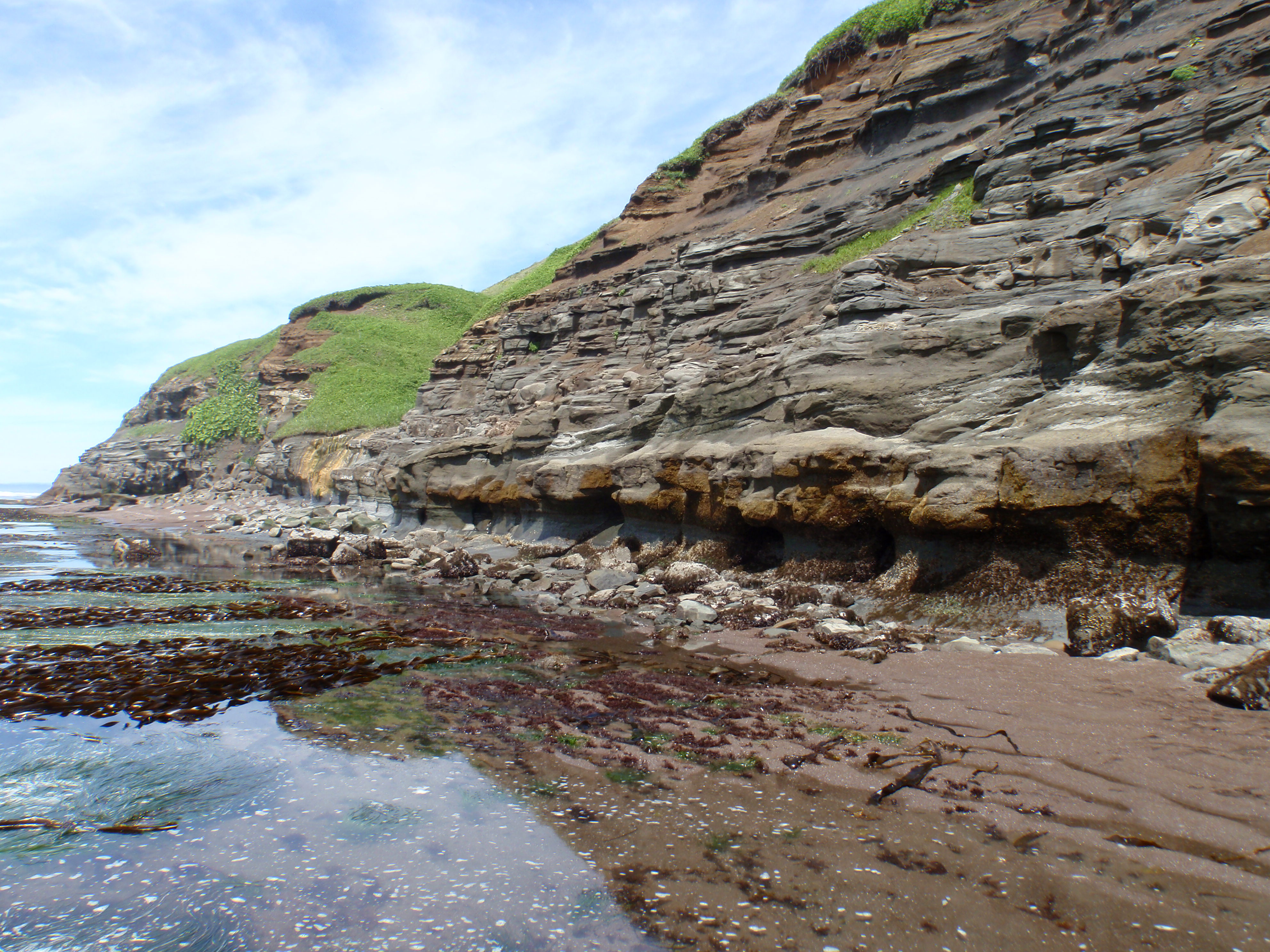
The Urahoro Group of Paleogene, which unconformably overlies the Nemuro Group (upper Cretaceous to Paleogene), is continuously distributed along the Kushiro coast, while the outcrop exposed of the latter is limited to a small area around Katsurakoi. The picture shows sea cliffs of the Yubetsu Formation of the Urahoro Groups. The Nemuro and Urahoro Groups in the area roughly strike NW-SE and dip about 5° SW, forming a homocline structure plunging into the Pacific Ocean.
(Photograph and Caption by Takayuki Sawaki)
Table of Contents
All the pages PDF : 65_05_full.pdf [7.9MB]
| Title | Author | |
|---|---|---|
| Report | ||
| The AMS 14C age of the debris flow deposits in the Nagashima area, central Mie Prefecture, southwest Japan |
Takeyuki Ueki(p67-70)
|
65_05_01.pdf [4.8MB] |
| Mesoscale crustal structure based on magnetic and gravity anomalies in the eastern part of Hokkaido, Japan. |
Rie Morijiri and Mitsuru Nakagawa(p71-84)
|
65_05_02.pdf [4MB] |
Abstract
The AMS 14C age of the debris flow deposits in the Nagashima area, central Mie Prefecture, southwest Japan
Takeyuki Ueki
The debris flow deposits buries the valley of Sono River, in the Nagashima area of Mie Prefecture, southwest Japan. The AMS 14C age of ca. 3,100 yrs BP was extracted from the pseudo-clast of humic soil in the uppermost horizon of debris flow deposits, suggesting that the timing of debris flow is 3,100 to 1,000 yrs BP.
Mesoscale crustal structure based on magnetic and gravity anomalies in the eastern part of Hokkaido, Japan.
Rie Morijiri and Mitsuru Nakagawa
A simple structural model explaining the gravity and magnetic anomalies was proposed along 2 profiles across the Pacific coast of the eastern Hokkaido (from Kushiro to Nemuro Peninsula). Recently, gravity and magnetic anomaly maps of offshore of this area were published. This area is characterized by high gravity and high magnetic anomalies. From the distribution of Nemuro formation, it was difficult to account for the source of highly positive gravity anomaly belt along the Nemuro Peninsula. Dolerites which compose a part of Nemuro formation were collected in this area. These samples have high density, susceptibility and strong NRM. Curie temperatures and Verwey transition indicate that magnetic carrier is mainly magnetite. Our 2-D modeling referred to these rock density and magnetic data. The result of it revealed that (1) the high gravity anomaly belt along Nemuro Peninsula was attributed to shallow dolerite bodies, and (2) high magnetic anomaly belts of offshore Kushiro was presumably caused by serpentinite.
Geological Survey of Japan, AIST
- About GSJ
- Our Activities
- Purchase guide
-
Publications and Database
- information
-
Bulletin of the Geological Survey of Japan
- bull2026(Vol.77)
- bull2025(Vol.76)
- bull2024(Vol.75)
- bull2023(Vol.74)
- bull2022(Vol.73)
- bull2021(Vol.72)
- bull2020(Vol.71)
- bull2019(Vol.70)
- bull2018(Vol.69)
- bull2017(Vol.68)
- bull2016(Vol.67)
- bull2015(Vol.66)
- bull2014(Vol.65)
- bull2013(Vol.64)
- bull2012(Vol.63)
- bull2011(Vol.62)
- bull2010(Vol.61)
- bull2009(Vol.60)
- bull2008(Vol.59)
- bull2007(Vol.58)
- bull2006(Vol.57)
- bull2005(Vol.56)
- bull2004(Vol.55)
- bull2003(Vol.54)
- bull2002(Vol.53)
- bull2001(Vol.52)
- Bulletin of the Geological Survey of Japan(old)
- Annual Report on Active Fault and Paleoearthquake Researches
- Reports, Geological Survey of Japan
- CCOP-GSJ Groundwater Project Report
- CCOP Technical Bulletin
- Cruise Report
- Geological Hazards
- Learning and Education
- GSJ Database Collection
- Collection of links