Bulletin of the Geological Survey of Japan Top Page
Bulletin of the Geological Survey of Japan Vol.64 No.7/8 (2013)
Cover photograph | Table of Contents | Abstract
Cover photograph
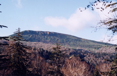 A view of the eastern side of Mt. Muine
Mt. Muine is an andesitic volcano that formed in the Pliocene in southwest Hokkaido. The altitude at the summit is 1,464 m. There are a number of hydrothermal veins that include Toyoha polymetallic (Zn, Pb, Ag, Cu, Sn and In) vein-type deposits, which are genetically related to volcanic activity. The Pliocene volcanic-hydrothermal system overprinted a Miocene volcanic-hydrothermal system. Combined with previous data on geological reconstruction and fluid inclusion studies, an oxygen isotopic study on hydrothermal vein quartz showed that the origins of the Pliocene and Miocene hydrothermal waters are distinct. For more information, see the related article in this volume.
(Photograph and Caption by Toru Shimizu)
Table of Contents
All the pages PDF : 64_07_full.pdf [7.5MB]
| Title | Author | |
|---|---|---|
| Article | ||
| Oxygen isotopic study of vein quartz in Neogene-Quaternary overprinting hydrothermal systems in the Toyoha-Muine area, Hokkaido, Japan | Toru Shimizu (191 - 200) |
64_07_01.pdf [2.8MB] |
| Vertical variation curves on the Pacific coast of Shikoku before the 1946 Nankai earthquake | Yasuhiro Umeda and Satoshi Itaba (201 − 211) |
64_07_02.pdf [1.1MB] |
| Report | ||
| Description and age estimate of the Ogoya Landslide in south Tokushima Prefecture, southwest Japan |
Takeyuki Ueki (213-219) |
64_07_03.pdf [1MB] |
| Note and Comment | ||
| New method for making petrographic sections of fragile rocks without using liquids as coolants or lubricants‒dry method‒ |
Akira Owada, Takumi Sato and Eri Hirabayashi (221-224) |
64_07_04.pdf [3.3MB] |
Abstract
Oxygen isotopic study of vein quartz in Neogene-Quaternary overprinting hydrothermal systems in the Toyoha-Muine area, Hokkaido, Japan
Toru Shimizu
An oxygen isotopic study of vein quartz in the Toyoha-Muine area was conducted using a CO2 laser microprobe technique, in order to determine origin of hydrothermal fluids. The oxygen isotopic values of the hydrothermal fluids resulting in the vein formations were calculated to be between -10.6 and 1.0‰, using the obtained oxygen isotopic values of quartz and previous data on the formation temperature of quartz from fluid inclusion studies. Combined with existing chronological data on the hydrothermal activities related to the vein formations, the isotopic values are classified into two different chronological ranges: -6.3 to 1.0 ‰ in Middle to Late Miocene and -10.6 to -6.7 ‰ in Pliocene-Pleistocene. Based on the previous geological reconstruction at the area, the values for the Middle to Late Miocene event indicate mixtures of fluids with variable ratios of meteoric water, seawater and magmatic water, whereas the values for Pliocene-Pleistocene result from fluids with high ratios of meteoric water to magmatic water.
Vertical variation curves on the Pacific coast of Shikoku before the 1946 Nankai earthquake
Yasuhiro Umeda and Satoshi Itaba
The long term vertical variations including 1946 Nankai earthquake have been obtained on the Pacific coast of Shikoku. However, the time of the datum just before the main shock was undefined,because it was obtained by human witness. From tidal record, the time was estimated to be between two high tides of which were the former spring tide and the day before the main shock. Within this time width, we proposed a logarithmic function to represent the vertical variation until the main shock. The time width was also confirmed by the witness testimonies for decrease of well water. We convert the decrease of well water to uplift of the ground. From the data of the time required for well water decrease and of the uplift of the ground, a gradient of the logarithmic function was estimated. The time width was limited from the vertical variation curves which were obtained from the level data of the Geographical Survey Institute and the gradient of logarithmic function. Finally, as a median of the time width, the time of the datum obtained just before the main shock was adopted to be 6.7days before the main shock. On the Pacific coast of Shikoku, the vertical variation curves until the main shock and the logarithmic functions as an approximate formula were determined. According to the function, it is estimated that in one month before the main shock, land has to 0.3m raised at Susaki, Kochi prefecture. This is consistent with witness testimony to say sea level has been reduced in Susaki bay.
Description and age estimate of the Ogoya Landslide in south Tokushima Prefecture, southwest Japan
Takeyuki Ueki
The Ogoya Landslide is a large failure of 8.6 ha area in south Tokushima Prefecture, southwest Japan. Both re-sedimented humic soil and tephric loess overlie the slide deposits composed of angular boulders of sandstone. The tephric loess intercalates a thin deformed humic soil layer with AMS 14C age of 4,050±40 yrs BP, and contains entirely volcanic glass shards of the 26-29 ka Aira-Tanzawa Tephra (AT). This stratigraphy suggests that the landslide predate to 26-29 ka. Average incision rate of the upper reach of Kaifu River after the failure is estimated to less than 1.0 mm/yr.
New method for making petrographic sections of
fragile rocks without using liquids as coolants or lubricants‒dry method‒
Akira Owada, Takumi Sato and Eri Hirabayashi
It is difficult to make thin sections of fragile and unstable specimens that contain sulfur, clay, salt, and water by applying the conventional method in which water and oil are used. Although such liquids protect samples from the heat generated during the cutting and grinding processes, they can also damage samples, for example, due to expansions. As a solution to this problem, a new method in which liquids are not used and frictional heat is minimized has been developed; in short, samples are not influenced by liquid and heat in this new method. This method enables to make easily the least damaged thin sections of such fragile samples. Further, this method can be adapted for even complex samples that contain both hard and soft minerals, and thus helps researchers obtain all possible information that can be obtained from the samples.
Geological Survey of Japan, AIST
- About GSJ
- Our Activities
- Purchase guide
-
Publications and Database
- information
-
Bulletin of the Geological Survey of Japan
- bull2026(Vol.77)
- bull2025(Vol.76)
- bull2024(Vol.75)
- bull2023(Vol.74)
- bull2022(Vol.73)
- bull2021(Vol.72)
- bull2020(Vol.71)
- bull2019(Vol.70)
- bull2018(Vol.69)
- bull2017(Vol.68)
- bull2016(Vol.67)
- bull2015(Vol.66)
- bull2014(Vol.65)
- bull2013(Vol.64)
- bull2012(Vol.63)
- bull2011(Vol.62)
- bull2010(Vol.61)
- bull2009(Vol.60)
- bull2008(Vol.59)
- bull2007(Vol.58)
- bull2006(Vol.57)
- bull2005(Vol.56)
- bull2004(Vol.55)
- bull2003(Vol.54)
- bull2002(Vol.53)
- bull2001(Vol.52)
- Bulletin of the Geological Survey of Japan(old)
- Annual Report on Active Fault and Paleoearthquake Researches
- Reports, Geological Survey of Japan
- CCOP-GSJ Groundwater Project Report
- CCOP Technical Bulletin
- Cruise Report
- Geological Hazards
- Learning and Education
- GSJ Database Collection
- Collection of links