Bulletin of the Geological Survey of Japan Top Page
Bulletin of the Geological Survey of Japan Vol.58 No.7/8 (2007)
Cover photograph | Table of Contents | Abstract
Cover photograph
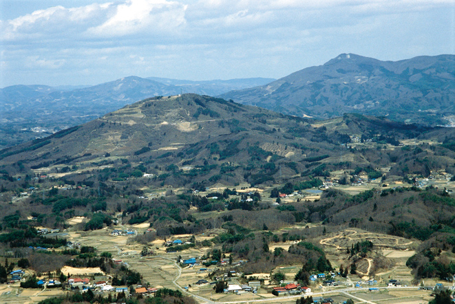
Gabbroic peaks in the Abukuma Mountains.
Northward view from the top of the Mt. Kuroishi (865 m). The front mountain is the Mt. Katasone (719 m), right hinder peak is Mt. Utsushigatake (994 m), and left side mountain behind the Mt. Katasone is the Mt. Hayama (897 m). The upper parts of those mountains consist of gabbroic rocks. When the boundary between the gabbroic masses and surrounding wall rocks is located on the level of 700 to 600 m high, the granodiorite around the gabbroic mass contains much amount of metamorphic sedimentary rocks, and in the case that the contact is lower than 500 m high, the dioritic hybrid rocks develop around the gabbroic masses. These facts indicate that the gabbroic masses are the roof pendant hanging down from sedimentary wall rocks over the Abukuma granitic rocks.
(Kazuya Kubo)
Table of Contents
| Title | Author | |
|---|---|---|
| Article | ||
| Preliminary study for speciation geochemical mapping using a sequential extraction method. | Atsuyuki Ohta, Noboru Imai, Shigeru Terashima and Yoshiko Tachibana (201-237) | 58_07_01.pdf [590 KB] |
| Physical properties of Cretaceous to Paleogene granitic rocks in Japan: Part 2. A case of the southern Tohoku region. |
Hiroshi Kanaya and Shigeo Okuma (239-252) | 58_07_02.pdf [865 KB] |
| Report | ||
| Description and age estimate of the Nariki Landslide, eastern margin of the Kanto Mountains, Ome city, central Japan. | Takeyuki Ueki (253-259) | 58_07_03.pdf [2,693 KB] |
Abstract
Preliminary study for speciation geochemical mapping using a sequential extraction method.
Atsuyuki Ohta, Noboru Imai, Shigeru Terashima and Yoshiko Tachibana
Sequential extraction is useful to assess the potential hazard of toxic metals and metal mobility in sediments. The extraction procedure developed by the Community Bureau of Reference (BCR) has been applied to the extraction of 51 elements from 30 stream sediments that were collected mainly for nationwide geochemical mapping in Japan. The geochemical reference samples, JSd-1, JSd-2 and JSd-3, were used to estimate the reproducibility of the elemental concentrations obtained using the BCR method. The BCR scheme is designed to extract elements in the intended phase using acetic acid (step 1), hydroxylammonium chloride (step 2), hydrogen peroxide and ammonium acetate (step 3), and hydrofluoric acid, perchloric acid, and nitric acid (step 4). The relative standard deviations of elemental concentrations in each extraction stage were generally less than ±10 - 25 %; the sums of elemental concentrations in respective steps (the total recoveries) ranged from 80 to 130 % of the bulk compositions in most cases. The extraction results for respective elements showed relative uniformity among the samples originated from various geological and lithological units, suggesting the limited influence of geology on the speciation of elements. In contrast, significant differences in the extraction results were found in samples from rural and urbanized areas even though they were all from sedimentary rock areas. Samples from urban areas were characterized by a higher proportion of Co, Ni, Zn and Cd extracted in step 1 and those of Cr, Cu, and Pb in step 3, probably indicating heavymetal contamination in their watersheds. Stream sediments near mining sites also showed a distinctive pattern in the extraction results. This study suggested that the BCR scheme is helpful for detecting the possible contamination of Cr, Ni, Cu, Zn, Cd, and Pb and exploring for mineral deposits bearing Zn, Cd and Pb.
Physical properties of Cretaceous to Paleogene granitic rocks in Japan: Part 2. A case of the southern Tohoku region
Hiroshi Kanaya and Shigeo Okuma
About 340 granitic rock samples (including 12 gabbroic rock samples) exposed in the Abukuma Mountains, southern Tohoku region, were collected and measured on their physical properties such as density, porosity, magnetic susceptibility and natural remanent magnetization (NRM).
Two tectonic lines, the Futaba Fracture Zone (FFZ) and Hatakawa Fracture Zone (HFZ) trend north in the east side of the Abukuma Mountains and the Tanagura Fracture Zone trends the NNW in the west side. Therefore, the Abukuma Mountains are divided into three areas by these tectonic lines. They are the east of the Futaba Fracture Zone, between of the Futaba Fracture Zone and the Hatakawa Fracture Zone, west of the Hatakawa Fracture Zone (between of the Hatakawa Fracture Zone and the Tanagura Fracture zone) and the South Area accompanied with metamorphic rocks. Eleven gabbroic rocks from the west of the HFZ and one from the South Area were collected and measured.
The measurement result was averaged for each area.
1. Density
The mean density of these areas varies from 2.68 to 2.74 x10³ kg/m3 (g/cm3) according to the means in the collected area, the lowest one is in the area between of the FFZ to HFZ, the second east of FFZ, the third west of HFZ, the highest is South Area . Gabbroic rock samples have a mean density of 3.03 x10³ kg/m3.
2. Porosity
The porosity shows from 0.53 to 0.68 % (with a mean value from 0.62 to 0.86 % and gabbroic rock has 0.27 %).
3. Magnetic susceptibility
All the samples can be sectioned within a zone bounded by two straight lines, in a densitymagnetic susceptibility chart: The samples in the Abukuma Mountains lie from near the lower line up to middle zone and are not distributed along the upper line except tonalite rock in the east of FFZ. The magnetic susceptibility of middle zone of the Abukuma Mountains is only a third or a quarter to that of the South Kitakami Mountains.
4. Natural Remanent Magnetization (NRM)
The relationship between the density and NRM could scarcely show correlation, but the magnetic susceptibility and NRM show more correlative. Konigsberger ratio (Qn) s of the 70 or more percent rock samples show less than 0.4. The low Qns are the same as the rock samples in the northern Tohoku region.
Description and age estimate of the Nariki Landslide, eastern margin of the Kanto Mountains, Ome city, central Japan.
Takeyuki Ueki
The Nariki Landslide is a large failure located in the Nariki Unit of Jurassic Chichibu sedimentary complex on the eastern margin of the Kanto Mountains, central Japan. The landslide is composed of a slide wall in the occurrence area, and upper and lower gentle slopes in the sedimentation area. Both upper and lower gentle slope deposits consist mainly of cobble to boulder-sized angular gravels and underlie tephric loess more than 1 m thick. The Nariki River carved out the lower gentle slope and formed late to latest Late Pleistocene fluvial terraces, suggesting that the failure should have occurred before the Late Pleistocene.
Geological Survey of Japan, AIST
- About GSJ
- Our Activities
- Purchase guide
-
Publications and Database
- information
-
Bulletin of the Geological Survey of Japan
- bull2026(Vol.77)
- bull2025(Vol.76)
- bull2024(Vol.75)
- bull2023(Vol.74)
- bull2022(Vol.73)
- bull2021(Vol.72)
- bull2020(Vol.71)
- bull2019(Vol.70)
- bull2018(Vol.69)
- bull2017(Vol.68)
- bull2016(Vol.67)
- bull2015(Vol.66)
- bull2014(Vol.65)
- bull2013(Vol.64)
- bull2012(Vol.63)
- bull2011(Vol.62)
- bull2010(Vol.61)
- bull2009(Vol.60)
- bull2008(Vol.59)
- bull2007(Vol.58)
- bull2006(Vol.57)
- bull2005(Vol.56)
- bull2004(Vol.55)
- bull2003(Vol.54)
- bull2002(Vol.53)
- bull2001(Vol.52)
- Bulletin of the Geological Survey of Japan(old)
- Annual Report on Active Fault and Paleoearthquake Researches
- Reports, Geological Survey of Japan
- CCOP-GSJ Groundwater Project Report
- CCOP Technical Bulletin
- Cruise Report
- Geological Hazards
- Learning and Education
- GSJ Database Collection
- Collection of links