Bulletin of the Geological Survey of Japan Top Page
Bulletin of the Geological Survey of Japan Vol.52 No.8 (2001)
Cover photograph | Table of Contents | Abstract
Cover photograph
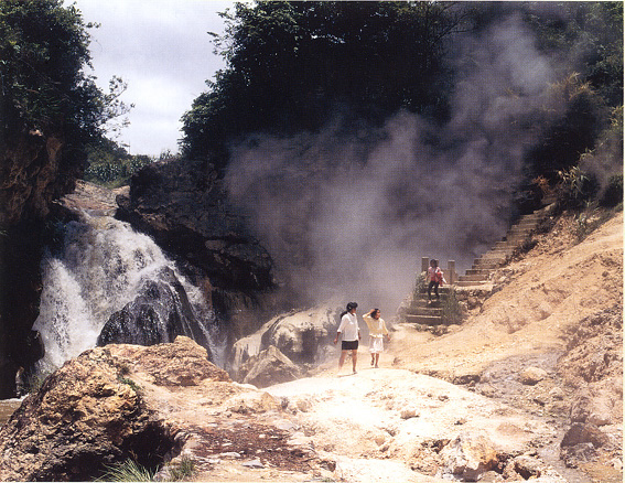
Rehai geothermal area in Tengchong, western Yunnan Provonce, China.
Western Yunnan in southern China is a tectonically vigorous zone influenced by the collision of the Indian subcontinet with Eurasia. Geothermal activity in Rehai area to the south of Tengchong is genetically related to Quaternary volcanoes and activ faults, and it is accompanied by hot spring-type epithermal gold deposits near Liuhungtang, a local hot spring resort. Photo was taken at Zaotang River in Rehai area in July, 1994. Refer to Sato et al. (1997), Geology news, no.513, 49-55.
(Photo and caption: SATO Kohei)
Table of Contents
| Title | Author | |
|---|---|---|
| Article | ||
| Geology and geochemistry of geothermal fields and hot-spring type gold deposits in Sanjiang orogen,southwestern China. | Pin'an WANG (327-346) | 52_08_01.pdf [4,281 KB] |
| Chemical composition of the alluvial soils from the Kanto District,Japan:Preliminary study for the soil geochemical mapping (part 2). | Shigeru TERASHIMA,Atsuyuki OHTA,Noboru IMAI,Takashi OKAI,Masumi MIKOSHIBA and Masahiro TANIGUCHI (347-370) | 52_08_02.pdf [4,366 KB] |
| Report | ||
| Geochemistry of bottom sediments from a river-estuary-shelf mixing zone on the tropical southwest coast of India. | SHAJAN Kuttickat Paul (371-382) | 52_08_03.pdf [1,882 KB] |
Abstract
Geology and geochemistry of geothermal fields and hot-spring type gold deposits in Sanjiang orogen, southwestern China.
Pin'an WANG
Sanjiang orogen is a NS-trending sollisional orogenic belt between Indian plate and Yangyze block of the South China plate, and also an important metallogenetic belt in southwestern China. The collision process between Eurasia plate and Indian plate started from Mesozoic times, which resulted in strong and frequent magmatic activities then after. After Cenozoic, the stronger and more frequent tectono-magmatism and volcanic eruptions provided fracture spaces and plenty of heat sources for epithermal activity in this area.
As an active geothermal field, the Rehai geothermal field situates in the southern part of the Sanjiang orogen, and is composed of two sub-scale geothermal fields-the Huanggua-qing-Liuhu-ang-tang in northeast and Reshui-tang in southwest. Rocks that outcrop in this geothermal field are mainly late Cretaceous granitoids with minor late Tertiary and Quaternary volcanics, sand-stone and conglomerate. Strong volcanisms in Pliocene to Pleistocene were recognized and early Pleistocene dacite and andicitic terrestrial volcanics distribute in the Huanggua-qing-Liuhuang-tang geothermal field (i.e.Rehai geothermal field in narrow sence). 62 hot spring groups occur along a NS-striking main fault in the Rehai geothermal field. Hydrochemical types of the spring water are mainly Na-Ca-HCO3 and Na-HCO3-Cl types; secandly Na-SO4 type, Na-Cltype, Ca-Na-HCO3-SO4 type and Mg-Ca-HCO3 type. Temperature of spring water on the surface is 24 ~ 102ºC, and pH value is 2 ~ 9.8. Geothermometers of SiO2, Na/K, Na-K-Ca, and Na-K-Ca-Mg, of the hot spring waters in the Rehai geothermal field, were used to evaluate the reservoir temperature, which yielded results of >270 ~ 100ºC from below 600m to the surface. The hydrothermal alteration and gold mineralization process are still going on that area, and the Lianghe gold deposit was formed between the Zao-tang River and the Xiao-shui River in Liuhuang-tang-Huanggua-qing geothermal area in the northeast sector of the geothermal field. This deposit about 6km² in area, with several kinds of spring sinter, hydrothermal alteration and breccia, and is one of the most recently formed hot spring-type gold deposits in China.
Spring sinters are of mainly silica sinter, with limited travertine, effloresce, flower of sulfur (sublimation sulfur) and gypsum sinter. Silica sinter is composed mainly of chalcedony and opal with mimor pyrite, marcasite, coffinite and pichblende. Gold content is 0.08 ~ 0.4g/t in present silica sinter, and 0.1 ~ 0.8g/t in fossil silica sinter.
Pyritization, silicification, argillic slteration, propylitization, sericitization, alunitization, zeolituzation and adularization are the major hydrothermal alteration types in the geothermal field and the Lianghe Au deposit where acid leaching alteration is widely developed. The alterationmineralization zoning from central part outward across a fault or fracture is as follows: strong silicified gold-bearing quartz zone → silicified-argillic altered zone → argillic altered zone → propylitization zone. Kaolinite, alunite, smectite, illite and dickite were formed by argillic alteration in acid leaching process. Very well-oldered kaorlinite in the Rehai geothermal field is found to be the best-ordered in China up to now, which has an Hc value of 1.67. Layered silica caps, fine quartz veins and stock work vein penetrating into acid leaching zone, are main appearances of Au mineralization.
Gold ore bodies ocure in NS-striking altered fractur zone as steeply dipping veins and complex veins accompanied by hydrothermal breccia. Ores are banded, lamellar, brecciform, and arsenopyrite, galena, and are composed of pyrite and marcasite as major metal minerals, and arsenopyrite, galena, sphalerite, chalcopyrite, stibnite, and nativ gold as minor metal minerals. Gangue minerals aer quartz, chalcedony, opal, jasper, with minor kaolinite, aluminite, illite, smecite, sericite, fluorite, and calcite.
Au content in hot spring water, surface sinter, bottom sinter, acid leaching zone, and stockwork quartz veins, is 0.01 ~ 0.16ppb, 0.001 ~ 0.63ppm, 0.004 ~ 0.17ppm, 0.001 ~ 0.73ppm, and 0.003 ~ 4.65ppm, respectively. Ag content in silica cap reaches 0.001 ~ 54.5ppm. Based on the average of Au and Ag content, Au/Ag ratio is always less that 0.1 (1:10 ~ 1:19). δ18OH2O, δDH2O, and δ13Cco2 values of hot spring waters in the Tengchong-Lianghe area are -12.3‰ ~ -5.1‰, -68.9‰ ~ -55.7‰, and -5.2‰ ~> -1.6‰, respectively. δ34S values of hot spring water, native sulfur, and sulfides such as pyrite, are mainly -2‰ ~ +2‰. Liquid composition of fluid inclusions in quartz from breccia of Liuhuangtang area is H2O 72%, H2S 28%; vapor composition is CO2 67.1%, H2S 12.6%, and H2 20.3%.
The δ18O values for quartz from quartz veins in the Lianghe gold deposit are between 5.0‰ and 8.8‰ (averaged 7.3‰ for 10 samples), and 2.3‰ ~ 12.4‰ (averaged 7.6‰ for 6 samples) for silicified Pliocene sandstone (whole rock).
Soil and rock geochemical investigation results suggest a tendency of high concentration or anomalies of Bi, Li, Rb, As, Sb, Hg, and Sn in or near hot spring areas, and Mn, Ni, Co, Pb, and Zn around or out of hot spring areas.
Chemical composition of the alluvial soils from the Kanto District, Japan:Preliminary study for the soil geochemical mapping (part 2).
Shigeru TERASHIMA, Atsuyuki OHTA, Noboru IMAI, Takashi OKAI, Masumi MIKOSHIBA and Masahiro TANIGUCHI
A total of 240 alluvial soils collected from the southern to northeastern Kanto district, Japan, were analyzed for major and minor elements to characterize the geochemical map of soil. It has been considered that these alluvial soils originated mainly from clastic materials derived from basement rocks and altered volcanic ashes. The chemical composition change of clastic materials from basement rocks in alluvial soils reflects the geology of catchment areas, whereas the change of altered volcanic ashes depends mainly on erupted volcanoes. The vertical variations of the elemental concentrations in alluvial soils are found in the cores. Compared to the mud layers, sand layers derived from basement rocks are generally smaller than volcanic ash soils. Several sand layers are poor in Al2O3, TiO3 and heavy metals, but rich in alkali and alkaili-earth metals in most cases. The elution and/or deposition of chemical elements result from the decreasing grain size during weathering. Compared to the volcanic ash soils, the alluvial soils are rich in alkali and alkali-earth metals, and depleted in Al2O3, TiO2 and heavy metals. The sedimentation rate of alluvial soils is estimated about 0.3 to 1.2mm/yr at some places. It is less than or equal to the rate of recent lake sediments, but much higher than volcanic ash soils (0.03-0.08mm/yr).
Geochemistry of bottom sediments from a river-estuary-shelf mixing zone on the tropical southwest coast of India.
SHAJAN Kuttickat Paul
Geochemical study of bottom sediments of the Periyar and Muvattupuzha rivers, Cchin estuary and the adjoining nearshore continental shelf was carried out to understand the distribution and enrichment pattern, sources, possible factors responsible for the enrichment and depletion of elements and environmental contamination of the systems. The river sediments are sand to sandy silt, estuarine sediments are sandy silt to clay and inner shelf sediments are mud. The study indicate that the sediment texture is the major controlling factor in the distribution of elements here. The fine grained sediments of the inner shelf and estuary are rich in MgO, CaO, Al2O3, TiO2, Fe2O3, Na2O, P2O5, K2O, MnO, Li, Sc, V, Cr, Co, Ni, Cu, Zn, As, Rb, Ta, Zr, Nb, Pb, LOI, and poor in SiO2. The organic rice sediments exhibit a similarity in the distribution of elements like Fe2O3, Al2O3, MgO, P2O5, Cu, Ni, Co, Cr and V. The other possible factors for the enrichment of certain elements are the presence of metal scavenging phases like Fe/Mn hydroxides and the higher content of heavy minerals in the area. The higher concentration of Fe2O3, MgO, P2O5, Zn, Ba, Pb, Cd, Bi and Cr in many samples indicates that all the sampling units are anthropologically contaminated, with the Periyar river and it's estuarine area showing maximum heavy metal contamination in the study area.
Geological Survey of Japan, AIST
- About GSJ
- Our Activities
- Purchase guide
-
Publications and Database
- information
-
Bulletin of the Geological Survey of Japan
- bull2026(Vol.77)
- bull2025(Vol.76)
- bull2024(Vol.75)
- bull2023(Vol.74)
- bull2022(Vol.73)
- bull2021(Vol.72)
- bull2020(Vol.71)
- bull2019(Vol.70)
- bull2018(Vol.69)
- bull2017(Vol.68)
- bull2016(Vol.67)
- bull2015(Vol.66)
- bull2014(Vol.65)
- bull2013(Vol.64)
- bull2012(Vol.63)
- bull2011(Vol.62)
- bull2010(Vol.61)
- bull2009(Vol.60)
- bull2008(Vol.59)
- bull2007(Vol.58)
- bull2006(Vol.57)
- bull2005(Vol.56)
- bull2004(Vol.55)
- bull2003(Vol.54)
- bull2002(Vol.53)
- bull2001(Vol.52)
- Bulletin of the Geological Survey of Japan(old)
- Annual Report on Active Fault and Paleoearthquake Researches
- Reports, Geological Survey of Japan
- CCOP-GSJ Groundwater Project Report
- CCOP Technical Bulletin
- Cruise Report
- Geological Hazards
- Learning and Education
- GSJ Database Collection
- Collection of links