Bulletin of the Geological Survey of Japan Top Page
Bulletin of the Geological Survey of Japan Vol.52 No.6/7 (2001)
Cover photograph | Table of Contents | Abstract
Cover photograph
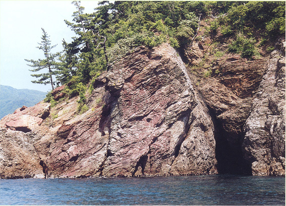
Chert outcrop at Nagozaki,Obama City,Fukui Prefecture. The chert is about 30m thic and laterally elongated for 1km, forming a sheet-like slab,and is also enveloped in pelitic mixed rock. Chert together with pelitic mixed rock is one of the major constituent elements of Jurassic accretionary complex of the Tamba Terrane.
(Photo and text by Satoshi NAKAE, Institute of Geoscience, Geological Survey of Japan, AIST)
Table of Contents
| Title | Author | |
|---|---|---|
| Article | ||
| Permian radiolarians from cherts of the Tamba Terrane in the Nishizu distric, Fukui, Southwest Japan. | Satoshi NAKAE (245-252) | 52_06_01.pdf [2,323 KB] |
| Distribution of subsurface temperature and grandwater flow system in the Kanto Plain. | Akinobu MIYAKOSHI and Youhei UCHIDA (253-290) | 52_06_02.pdf [5,266 KB] |
| Fission trac age of the Kt-7 Tuff Miocene Kubota Formation in the eastern Tanagura area, Northeast Japan. | Masaki TAKAHASHI, Hideki IWANO, Yukio YANAGISAWA and Hiroki HAYASHI (291-302) | 52_06_03.pdf [1,700 KB] |
| Short Article | ||
| Tsukaharano debris avalanche deposit wiht imbricate stractur and 14C age on the southwest hoot of Kyogatake Volcano, Fukui Prefecture, central Japan. | Koji MIMURA (303-308) | 52_06_04.pdf [607 KB] |
| K-Ar dating of Nanatsumori volcanic rocks, Kamurodake and Aoso Volcanoes along the Quaternary volcanic front of northeast Japan. | Koji MIMURA (309-314) | 52_06_05.pdf [466 KB] |
| Zinc-bearing actinolite from the Kakkonda geothermal system, Iwate Prefecture, northeastern Japan. | Takayuki SAWAKI, Munatake SASAKI, Koichiro FUJIMOTO and Naoto TAKENO (315-320) | 52_06_06.pdf [830 KB] |
| Notes and Comments | ||
| ExpFit.nb : A MATHEMATICA program for the data processing of transverse relaxation times in nuclear magnetic resonance logging | Yoshinori WATANABE and Yoshito NAKASHIMA (321-325) | 52_06_07.pdf [379 KB] |
Abstract
Permian radiolarians from cherts of the Tamba Terrane in the Nishizu distric, Fukui, Southwest Japan.
Satoshi NAKAE
Permian radiolarians are detected from cherts of the Tamba Terrane in the Nishizu district, southwestern Fukui Prefecture. The Tamba terrane exposed in the district is mainly composed of basalt, limistone, chert, mudstone and sandstone.It is characterized by a chaotic mixture of these rocks;i, e., slabs of basalt, limestone, chart, mudstone and sandstone are embedded in pelitic mixed rocks. Only a few biostratigraphical studies in the district have previously been appeared and some of them discribed the occurrence of Permian, Triassic and Jurassic radiolarians, but the ages of the rocks constituting the Tamba Terrane in the district are still ncertained.Newly recovered radiolarians treated herein can give the chert sequence in the Nishizu district additoinal ages of late Early, middle Middle and Late Peremian.Moreover, cherts generally occure as slabs, which are classified into small-scale lenticular and lage-scale sheet-like types, both of which are assigned to Permian in age.
Distribution of subsurface temperature and grandwater flow system in the Kanto Plain.
Akinobu MIYAKOSHI and Youhei UCHIDA
Temterature-depth profiles and grandwater levels were measured on 88 observation wells in the Kanto Plain. From observation results, subsurface temperature distribution in the Kanto Plain is assumed to strongly affectid by thermal advection due to grandwater flow, which has regional diffence between high temperature area and low temperature area. The high temperature area is lacated in a low land around the Kinu, Tone Rivers and central part of the Kanto Plain. The low temperatur area, on the other hand, is located in a high land and/or a mountain area around the Kanto Plain. Considering from observed distribusion of subsurface temperatures and hydraulic heats, two local grandwater flow system which discherge to the Tone River in the Gunma Prefecture and to the Kinu River in the Tochigi Prefectur, and one regional grandwater flow system which recherged in the peripheral area in the plain and discherges to central part of the plain are estimatied.Moreover, there are subsurface temperature inversions in shallow layer due to the effect of surface warming.The distribution of inversion in the Kanto Plain has tendency that the depth of inversion in the recherge area is deeper than that in the discharge aera, and this tendency suggests the existence of the regional grandwater flow system in the Kanto Plain.
Fission trac age of the Kt-7 Tuff Miocene Kubota Formation in the eastern Tanagura area, Northeast Japan.
Masaki TAKAHASHI, Hideki IWANO, Yukio YANAGISAWA and Hiroki HAYASHI
The fission track dating was aspplied for the Kt-7 Tuff, interbedded in the uppermost part of the Miocene Kubota Formation in the eastern Tanagura area, Northeast Japan. The fission track age of the Kt-7 Tuff (10.6±0.3Ma;1 σ error ) is almost equal to the K-Ar and fission track ages of the Kt-1 Tuff, interbedded in the lowest part of the Kubota Formation. These radiometric ages show good agreement with the previously established calcareous and siliceous microfossil biostratigraphy. The integrated stratigraphy based on microfossils as wall as K-Ar and fission track ages indicate a high sedimentation rate of the Kubota Formation.
Tsukaharano debris avalanche deposit wiht imbricate stractur and 14C age on the southwest hoot of Kyogatake Volcano, Fukui Prefecture, central Japan.
Koji MIMURA
Tsukaharano debris avalanche deposit of 0.3 km3 was derved from Kyogatake Volcano which forms an andesitic cone of middle Pleistocene. The avalanche deposit spreads over the southwestern foot of the volcano, reaching as far as 11km and 1.4km down from the source Kyogatake. The deposit forms a debris plateau called Tsukaharano which is 10-25m high and 2.5km square, and is accompanied with many hummocky hills. The deposit sonsists of a chaotic mixture of mostly fumarolic alterd lava and fragile pyroclastic rocks which often sorms flameshape blocks showing imbricatte structure. The avalanche was associated with neither magmatic nor phreati eruption. 14C ages of peat soils on and under the avalanche deposit show ages about 5 and 6.7 ka respectively. They are much younger than the active time of the source volcano. Most likely an earthquake caused the avalanche.
K-Ar dating of Nanatsumori volcanic rocks, Kamurodake and Aoso Volcanoes along the Quaternary volcanic front of northeast Japan.
Koji MIMURA
Three K-Ar ages were measured on the volcanic rocks along the Quaternary volcanic front of NE Japan. The results are 2.3 Ma on Nanatsumori volcanic rocks, 1.7 Ma on Kamurodake Volcano and 0.7 Ma on aoso Volcano. These data suggest the volcanic front moved to the present location from the east to the west after about 2 Ma.The same movement of the volcanic front is recognized in the Fossa Magna region, cantral Japan, which is the southern extension of the volcanic front of NE Japan.
Zinc-bearing actinolite from the Kakkonda geothermal system, Iwate Prefecture, northeastern Japan.
Takayuki SAWAKI, Munatake SASAKI, Koichiro FUJIMOTO and Naoto TAKENO
Zinc-bearing actinolite was found in a hydrothermal vein of a drill core retrieved at 1,223 m in depth of the deep reseach well, WD-1, which had been drilled in the Kakkonda geothermal area, northeastern Japan. Zinc-bearing actinolite is fibrous and occurs with sphalerite chalcopyrite, pyrite, quartz, anhydrite, epidote and clay minerals in the vein. The ZnO content of actinolite ranges in 0.4-1.5 wt.%, relatively higt compared with Zinc-bearign calcic amphiboles in stage of geothermal activity in Kakkonda.
Geological Survey of Japan, AIST
- About GSJ
- Our Activities
- Purchase guide
-
Publications and Database
- information
-
Bulletin of the Geological Survey of Japan
- bull2026(Vol.77)
- bull2025(Vol.76)
- bull2024(Vol.75)
- bull2023(Vol.74)
- bull2022(Vol.73)
- bull2021(Vol.72)
- bull2020(Vol.71)
- bull2019(Vol.70)
- bull2018(Vol.69)
- bull2017(Vol.68)
- bull2016(Vol.67)
- bull2015(Vol.66)
- bull2014(Vol.65)
- bull2013(Vol.64)
- bull2012(Vol.63)
- bull2011(Vol.62)
- bull2010(Vol.61)
- bull2009(Vol.60)
- bull2008(Vol.59)
- bull2007(Vol.58)
- bull2006(Vol.57)
- bull2005(Vol.56)
- bull2004(Vol.55)
- bull2003(Vol.54)
- bull2002(Vol.53)
- bull2001(Vol.52)
- Bulletin of the Geological Survey of Japan(old)
- Annual Report on Active Fault and Paleoearthquake Researches
- Reports, Geological Survey of Japan
- CCOP-GSJ Groundwater Project Report
- CCOP Technical Bulletin
- Cruise Report
- Geological Hazards
- Learning and Education
- GSJ Database Collection
- Collection of links