Bulletin of the Geological Survey of Japan Vol.49 No.11 (1998)
Cover photograh | Table of Contents |
Cover photograh
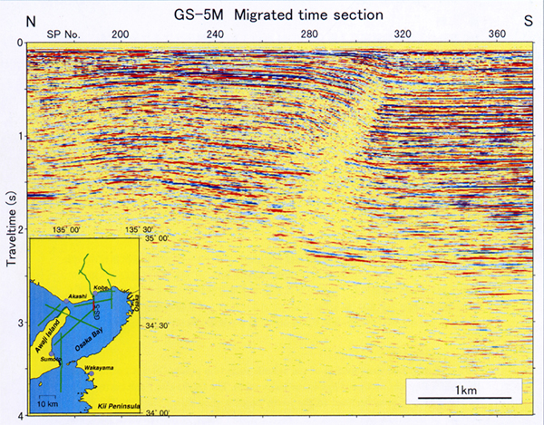
Part of migrated time section of the seismic reflection profile GS-5M conducted in the Osaka Bay (shown by red line in the index map)
The Osakawan Fault corresponds to non-reflective area declined to the north beneath shot points 280-310. The upper surface of basement lies around 1.5-1.6s (1.7-1.9km deep) in the northern part, and around 2.2-2.3s (2.7-2.9km deep) in the southern part. The overlying strata, except the shallowest part, correspond to the soft sediments of the Pliocene-Pleistocene Osaka Group.
Table of Contents
| Title | Author | |
|---|---|---|
| Nanometer-scale structures in a Mn-Mg-Fe Amphibole from Vittinki Group, Western Finland | Franco MANCINI, Katsumi MARUMO, Reijo ALVIOLA, Norihiko KOHYAMA, Brian MARSHALL (551-569) | 49-11_01.pdf(6,847KB) |
| Seismic profiling of deep geological structure in the Osaka Bay area | Takanobu YOKOKURA, Naomi KANO, Kazuo YAMAGUCHI, Teruki MIYAZAKI, Takeshi IKAWA, Yohichi OHTA, Taku KAWANAKA and Susumu ABE (571-590) | 49-11_02.pdf(8,709KB) |
| [ Notes ] Utilization of Geological Map of Japan 1:1,000,000 3rd Edition CD-ROM version with scientific visualization software -customization of IRIS Explorer modules for importing geological data and topographical data |
Naoto TAKENO (591-597) | 49-11_03.pdf(3,380KB) |
| [ Notes ] Data processing of X-ray CT scan image (1) -Prepare processing and 3D view |
Xinglin LEI (599-603) | 49-11_04.pdf(3,071KB) |