Bulletin of the Geological Survey of Japan Top Page
Bulletin of the Geological Survey of Japan Vol.73 No.1 (2022)
Cover photograph | Table of Contents | Abstract
Cover photograph
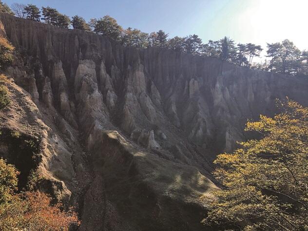
Awa no Dochu (earth pillars of Awa)
The Pleistocene Dochu Formation distributed in the Tokushima Plain is fluvial deposit composed of gravel, sand, and mud originating from the Shikoku and Asan mountains. Awa no Dochu is known for its erosion landform with the forest of earth pillars and is designated as a national natural monument.
(Photograph and Caption by HANEDA Yuki and NAKASHIMA Rei)
Table of Contents
All the pages PDF : 73_01_full.pdf [9.6MB]
| Title | Author | |
|---|---|---|
| Article | ||
| Subsurface Pleistocene magnetostratigraphy under the Aburagafuchi Lowland in the southwestern Nishi-mikawa Plain, central Japan |
HANEDA Yuki, NAKATANI Koretaka and MIZUNO Kiyohide (p1-17)
|
73_01_01.pdf [3.6MB] |
| Seismic reflection survey at Konan Town, Saitama Prefecture, Japan: linear dependence of the dip angles of reflection layers with depth |
OHTAKI Toshiki, KANO Naomi and YOKOKURA Takanobu (p19-28)
|
73_01_02.pdf[5.3MB] |
Abstract
Subsurface Pleistocene magnetostratigraphy under the Aburagafuchi Lowland in the southwestern Nishi-mikawa Plain, central Japan
HANEDA Yuki, NAKATANI Koretaka and MIZUNO Kiyohide
We conducted paleomagnetic, rock-magnetic, and tephra analyses for the 80 m-deep core GS-HKN-1, which was drilled at the Aburagafuchi Lowland, Hekinan City, Aichi Prefecture in 2018, to constrain the depositional age of the subsurface Pleistocene in the Nishi-mikawa Plain. Progressive alternating field demagnetization was conducted for samples obtained from 73 horizons, and then we assigned paleomagnetic polarity zones based on resulting paleomagnetic inclinations. In combination with the previously reported palynostratigraphy, it is thought that a polarity transition between 40.44 and 40.75 m within a non-marine mud bed is correlated to the Matuyama–Brunhes (M–B) boundary. The stratigraphic position of the M–B boundary is consistent with those in oxygen isotope stratigraphy from the Boso Peninsula, and North Atlantic. Volcanic glasses in muddy beds below the M–B boundary are likely admixture of several reworked tephra beds, based on large deviations of those refractive indexes and major and trace element components. In the future, additional thermomagnetic experiments, and pollen analysis are required to evaluate the magnetostratigraphy and correlate muddy beds to Marine Isotope Stages.
Seismic reflection survey at Konan Town, Saitama Prefecture, Japan: linear dependence of the dip angles of reflection layers with depth
OHTAKI Toshiki, KANO Naomi and YOKOKURA Takanobu
We performed a seismic reflection survey using 3-component geophones with P-wave vibrators in lowlands near the Arakawa River at Konan Town, Saitama Prefecture, Japan, in 2001. The direction and length of the survey line are from approximately east to west and 2 km, respectively. This survey was originally planned to obtain S-wave velocity of tilted underground structure using P–SV reflected waves. Unfortunately, we found only one or two clear P–SV reflected waves on each receiver gathers, which are not enough to determine the velocity. However, we also performed P-wave reflection analysis using vertical component of the geophones. In this paper, we show the two-dimensional P-wave velocity profiles and depth section along the reflection survey to a depth of about 1 km. The velocities beneath the survey are obtained as from 200 to 300 m/s near the surface, from 400 to 700 m/s at 100-m depth, from 1,400 to 1,800 m/s at 500 m-depth, and from 2,700 to 3,000 m/s at 1,000-m depth. The obtained depth profile shows several dipping layers from west to east. The dip angles of the layers measured along the survey increase approximately linearly with depth from 7° to 12° at a rate of 5–6 °/km, indicating that the inclination of the sedimentary layers caused by fault movement had increased at an approximately constant rate with age in this area. These dipping layers are also observed in the depth profile of a previous P-wave reflection survey that was performed about 1-km west of the survey at Konan Town with the direction from south-west to north-east. Combined with their results, our findings suggest that the sedimentary layers beneath the surveys tilt to the approximately north-east direction.
Geological Survey of Japan, AIST
- About GSJ
- Our Activities
- Purchase guide
-
Publications and Database
- information
-
Bulletin of the Geological Survey of Japan
- bull2026(Vol.77)
- bull2025(Vol.76)
- bull2024(Vol.75)
- bull2023(Vol.74)
- bull2022(Vol.73)
- bull2021(Vol.72)
- bull2020(Vol.71)
- bull2019(Vol.70)
- bull2018(Vol.69)
- bull2017(Vol.68)
- bull2016(Vol.67)
- bull2015(Vol.66)
- bull2014(Vol.65)
- bull2013(Vol.64)
- bull2012(Vol.63)
- bull2011(Vol.62)
- bull2010(Vol.61)
- bull2009(Vol.60)
- bull2008(Vol.59)
- bull2007(Vol.58)
- bull2006(Vol.57)
- bull2005(Vol.56)
- bull2004(Vol.55)
- bull2003(Vol.54)
- bull2002(Vol.53)
- bull2001(Vol.52)
- Bulletin of the Geological Survey of Japan(old)
- Annual Report on Active Fault and Paleoearthquake Researches
- Reports, Geological Survey of Japan
- CCOP-GSJ Groundwater Project Report
- CCOP Technical Bulletin
- Cruise Report
- Geological Hazards
- Learning and Education
- GSJ Database Collection
- Collection of links