Bulletin of the Geological Survey of Japan Top Page
Bulletin of the Geological Survey of Japan Vol.72 No.5 (2021)
Cover photograph | Table of Contents | Abstract
Cover Figure
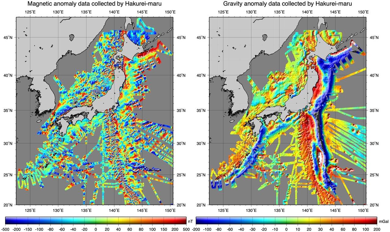
Magnetic anomaly map and free air gravity anomaly map around Japan
Magnetic anomaly map (left) and gravity anomaly map (right). The maps were created with the proton magnetometer and marine gravimeter data obtained in the cruises of the Hakurei-maru from 1974 to 1999, which were carried out by the Geological Survey of Japan. The magnetic anomaly data were calculated using the CM4 model to reduce magnetic secular and diurnal variations, and applied with leveling correction. The gravity anomaly data were obtained by applying the gravimeter drift and scale conversion correction, low-pass filtering, altimetric gravity data correction and leveling correction.
(Figure and Caption by ISHIHARA Takemi)
Table of Contents
All the pages PDF : 72_05_full.pdf [21MB]
| Title | Author | |
|---|---|---|
| Article | ||
| The Middle to Late Pleistocene tephrostratigraphy around the Nasu Volcano Group, NE Japan: new description of the Kawatani Pyroclastic Fall Deposit and the horizon of the Yosasagawa and Higashi-iwazaki Debris Avalanche Deposits | YAMAMOTO Takahiro (p397-420) | 72_05_01.pdf[10MB] |
| Preparation and release of gravity and magnetic data collected by R/V Hakurei-maru | ISHIHARA Takemi (p421-445) | 72_05_02.pdf [5.6MB] |
| Report | ||
| Geochemistry of chromian spinels from serpentinites distributed in eastern margin of the Kanto Mountains | HARA Hidetoshi and HISADA Ken-ichiro (p447-458) | 72_05_03.pdf [19.4MB] |
Abstract
The Middle to Late Pleistocene tephrostratigraphy around the Nasu Volcano Group, NE Japan: new description of the Kawatani Pyroclastic Fall Deposit and the horizon of the Yosasagawa and Higashi-iwazaki Debris Avalanche Deposits
YAMAMOTO Takahiro
The stratigraphy and lithology of the Late to Middle Pleistocene pyroclastic fall deposits (PFDs) and debris avalanche deposits( DADs) distributed in the eastern foothills of the Nasu Volcano Group have been redescribed with new data of major element compositions of glass shards in pyroclastic materials. In Mafune-Kawatani, Nishigo Village, there is un-named dacite pumice lapilli layer immediately above the Nasu-Shirakawa PFDs, which were erupted from Asahidake and Minamigassan Volcanoes of the group during 0.16 to 0.12 Ma; this unit have been newly defined as the Kawatani PFD. Its distribution and glass composition suggest that this fall deposit also originated from the Nasu Volcano Group. The chemical composition of the pumice gravel below the Yosasagawa DAD is consistent with that of the Otawara Pyroclastic Flow Deposit of 0.32 Ma. Therefore, the tephrostratigraphic age of the Yosasagawa DAD is 0.32 to 0.23 Ma. On the other hand, the Higashi-iwazaki DAD, which is defined in this study and thought to originate from the Nasu Volcano Group, has been identified in the lower part of the Mafune PFDs. The tephrostratigraphic age of the Higashi-iwazaki DAD is estimated to be 0.35 to 0.34 Ma.
Preparation and release of gravity and magnetic data collected by R/V Hakurei-maru
ISHIHARA Takemi
One-minute interval good-quality gravity and magnetic data were prepared for most of the Hakurei-maru cruises carried out by Geological Survey of Japan from 1974 to 1999. The RMS COD (root mean square crossover difference) of all the magnetic data after leveling correction is 26.1 nT, while that of all the gravity data after altimetry and leveling corrections is 3.2 mGal. These data can create a magnetic anomaly map without false lineations along survey lines and a free air gravity anomaly map, which has better quality than a map created using satellite altimetry data.
Three types of data files were released as an open-file report of Geological Survey of Japan, no. 714: a master data file, which has corrected navigation data and observed data, a gravity and depth data file and a magnetic data file, which include data after gravity and magnetic anomaly calculation.
Geochemistry of chromian spinels from serpentinites distributed in eastern margin of the Kanto Mountains
HARA Hidetoshi and HISADA Ken-ichiro
We report geochemistry of chromian spinels from serpentinites distributed in the eastern margin of the Kanto Mountains. The serpentinites in this area are observed in three geological units, 1) Sanbagawa metamorphic rocks (Kobunoyama Serpentinite), 2) Mikabu greenstones, 3) Chichibu accretionary complex (Komataka Serpentinite). The geochemical data of chromian spinels were examined using Cr–Al–Fe3+ relationship, Cr# = Cr/(Cr+Al) atomic ratio, Mg# = Mg/(Mg+Fe2+) atomic ratio, YFe = Fe3+/(Cr+Al+Fe3+) atomic ratio, and TiO2 wt%. The chromian spinels of the Kobunoyama Serpentinite within the Sanbagawa metamorphic rocks present Cr# (0.49–0.50) and Mg# (0.56–0.60), and TiO2 concentration (less than 0.04 wt%). The chromian spinels of serpentinites within the Mikabu greenstones show a negative correlation between Cr# (0.33–0.66) and Mg# (0.01–0.38), and TiO2 concentration (3.6–13.3 wt%). In addition, Mg# and Fe3+ concentration suggest that the chromian spinels were subjected to alternation and metamorphism, and have no original geochemical information in the Mikabu greenstones. The chromian spinels of the Komataka Serpentinite within the Chichibu accretionary complex present Cr# (0.37–0.49), Mg# (0.63–0.66), and TiO2 concentration (less than 0.4 wt%), presenting similar geochemical data from the Kobunoyama Serpentinite. The chromian spinels of the Komataka and Kobunoyama serpentinites are characterized by lower Cr# and higher Mg# against those of the serpentinites interpreted as eastern extension of the Kurosegawa Belt (Southern margin of Sanchu Cretaceous System, Naguri Fault, Kiroko Mélange).
Geological Survey of Japan, AIST
- About GSJ
- Our Activities
- Purchase guide
-
Publications and Database
- information
-
Bulletin of the Geological Survey of Japan
- bull2026(Vol.77)
- bull2025(Vol.76)
- bull2024(Vol.75)
- bull2023(Vol.74)
- bull2022(Vol.73)
- bull2021(Vol.72)
- bull2020(Vol.71)
- bull2019(Vol.70)
- bull2018(Vol.69)
- bull2017(Vol.68)
- bull2016(Vol.67)
- bull2015(Vol.66)
- bull2014(Vol.65)
- bull2013(Vol.64)
- bull2012(Vol.63)
- bull2011(Vol.62)
- bull2010(Vol.61)
- bull2009(Vol.60)
- bull2008(Vol.59)
- bull2007(Vol.58)
- bull2006(Vol.57)
- bull2005(Vol.56)
- bull2004(Vol.55)
- bull2003(Vol.54)
- bull2002(Vol.53)
- bull2001(Vol.52)
- Bulletin of the Geological Survey of Japan(old)
- Annual Report on Active Fault and Paleoearthquake Researches
- Reports, Geological Survey of Japan
- CCOP-GSJ Groundwater Project Report
- CCOP Technical Bulletin
- Cruise Report
- Geological Hazards
- Learning and Education
- GSJ Database Collection
- Collection of links