Bulletin of the Geological Survey of Japan Top Page
Bulletin of the Geological Survey of Japan Vol.72 No.3 (2021)
Cover photograph | Table of Contents | Abstract
Cover photograph
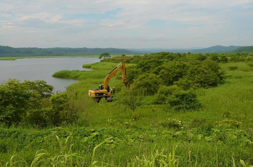
The Holocene oyster shellbeds along the eastern coast of Pashukurutou Lagoons facing the Pacific coast of eastern Hokkaido
We conducted a trenching survey to clarify the formative processes of the Holocene oyster shellbeds along the eastern coast of the Pashukurutou Lagoon, located in the south of the Shiranuka Hills on the Pacific coast of eastern Hokkaido, northeastern Japan. The result suggests that the oyster reefs may have formed at about 7400 cal BP and continued growing until 5600 cal BP. At least five destructive processes seems to have occurred during the 1800 years of their existence, such as strong and high waves including tsunami flows generated at the Kuril subduction zone. The water in the left of the photo is the Pashukurutou Lagoon, which was an inner bay during the Jomon marine transgression. The marsh covers the area of the ancient inner bay around the lagoon. The mountains in far distance are the Shiranuka Hills.
(Photo and Caption by NANAYAMA Futoshi)
Table of Contents
All the pages PDF : 72_03_full.pdf [13MB]
| Title | Author | |
|---|---|---|
| Article | ||
| Destruction and restoration processes of fossil oyster reef influenced by repeated large-scale waves: An example of Holocene Crassostrea gigas shellbeds around Pashukurutou Lagoon, eastern Hokkaido, northeast Japan | NANAYAMA Futoshi, ANDO Hisao, KONDO Yasuo, YOKOYAMA Yoshiharu, NAKATA Akiko,SASAJIMA Yui, SHIGENO Kiyoyuki, FURUKAWA Ryuta and ISHII Masayuki (p139-171) | 72_03_01.pdf[6.7MB] Correction in name spelling (in Japanese) (June 29, 2021) |
| Geochemical composition and origin of mafic rocks of the Jurassic accretionary complex in the North Kitakami Belt, the Kuji area, Iwate Prefecture, Northeast Japan | NAKAE Satoshi (p173-190) | 72_03_02.pdf [7MB] |
Abstract
Destruction and restoration processes of fossil oyster reef influenced by repeated large-scale waves: An example of Holocene Crassostrea gigas shellbeds around Pashukurutou Lagoon, eastern Hokkaido, northeast Japan
NANAYAMA Futoshi, ANDO Hisao, KONDO Yasuo, YOKOYAMA Yoshiharu, NAKATA Akiko, SASAJIMA Yui, SHIGENO Kiyoyuki, FURUKAWA Ryuta and ISHII Masayuki
We tried to clarify the formative processes of the Holocene oyster shellbeds exposed along the eastern coast of Pashukurutou Lagoon in the southern part of Shiranuka Hills facing the Pacific coast of eastern Hokkaido, northeastern Japan, on the basis of a) detailed observations of a lake-side outcrop and five trench wall sections on lithostratigraphy, shellbed morphology and taphonomy, b) molluscan composition analysis, c) AMS 14C dating of shell and wood fragment samples, etc. We summarize the results as follows: (1) Considering the continuity of lithologic units and the characteristics of their bounding surfaces, the Holocene strata 4.1 m thick at maximum can be divided into six lithostratigraphic units, SU-X, SU-A, SU-B, SU-C, SU-D and SU-E; (2) The SU-B constitutes a composite oyster shellbed 2.2 m thick at maximum of interbedded allochthonous (FB-a, c, e, g) and three autochthonous (FB-b, d, f) shellbed units; (3) Oyster reef may have begun to form in the Pashukurutou Lagoon area at about 7400 cal BP, and continued to grow up until 5600 cal BP. At least five destructive processes of these allochthonous shellbeds such as strong and high waves, possibly including tsunami flows derived from the Kuril subduction zone, might have occurred during about 1800 years; (4) In the Pashukurutou Lagoon area, the Holocene sea level existed between 2.1–2.8 m at 5600 cal BP, and had declined by about 2–3 m to the present. This is presumed to be the influence of seismic uplift around the Sriranuka Hills caused by a trench-type earthquake in the Kuril subduction zone.
Geochemical composition and origin of mafic rocks of the Jurassic accretionary complex in the North Kitakami Belt, the Kuji area, Iwate Prefecture, Northeast Japan
NAKAE Satoshi
For the purpose of understanding their origin, mafic rocks (basalt and dolerite) included in the Jurassic accretionary complex in the North Kitakami Belt in the Kuji area, Iwate Prefecture, were geochemically analyzed by using XRF and ICP-MS. In this belt, the Akka–Tanohata and Kuzumaki–Kamaishi subbelts are distinguishable from one another by their oceanic rocks having clearly different age, and the both are also subdivided into several formations. The mafic rocks in the Kuji area are mostly distributed in the Sawayamagawa and Kassenba formations; the former belongs to the Akka–Tanohata subbelt and the latter to the Kuzumaki–Kamaishi subbelt. As a result of the analysis, low FeO*/MgO ratio (< 2.23) suggests that the mafic rocks of the Sawayamagawa Formation originated from relatively undifferentiated basaltic magma. Most of the Sawayamagawa mafic rocks are displayed on the fields of oceanic island basalt (OIB) and within-plate basalt (WPB) of various discrimination diagrams. The basalt of the Kassenba Formation is considered to be derived from more differentiated basaltic magma (FeO*/MgO ratio = 3.78) than the Sawayamagawa mafic rocks, and plots on some discrimination diagrams indicate that OIB and WPB are the most suitable nominations for its origin, although they are plotted on the fields of MORB and/or island arc basalt of another discrimination diagram due to high Y concentration. The mafic rocks of both formations contain high concentrations of incompatible HFS elements and light rare earth elements, closely resembling OIB patterns in the N-type MORB- and chondrite-normalized diagrams.
Geological Survey of Japan, AIST
- About GSJ
- Our Activities
- Purchase guide
-
Publications and Database
- information
-
Bulletin of the Geological Survey of Japan
- bull2026(Vol.77)
- bull2025(Vol.76)
- bull2024(Vol.75)
- bull2023(Vol.74)
- bull2022(Vol.73)
- bull2021(Vol.72)
- bull2020(Vol.71)
- bull2019(Vol.70)
- bull2018(Vol.69)
- bull2017(Vol.68)
- bull2016(Vol.67)
- bull2015(Vol.66)
- bull2014(Vol.65)
- bull2013(Vol.64)
- bull2012(Vol.63)
- bull2011(Vol.62)
- bull2010(Vol.61)
- bull2009(Vol.60)
- bull2008(Vol.59)
- bull2007(Vol.58)
- bull2006(Vol.57)
- bull2005(Vol.56)
- bull2004(Vol.55)
- bull2003(Vol.54)
- bull2002(Vol.53)
- bull2001(Vol.52)
- Bulletin of the Geological Survey of Japan(old)
- Annual Report on Active Fault and Paleoearthquake Researches
- Reports, Geological Survey of Japan
- CCOP-GSJ Groundwater Project Report
- CCOP Technical Bulletin
- Cruise Report
- Geological Hazards
- Learning and Education
- GSJ Database Collection
- Collection of links