Bulletin of the Geological Survey of Japan Top Page
Bulletin of the Geological Survey of Japan Vol.71 No.1 (2020)
Cover photograph | Table of Contents | Abstract
Cover photograph
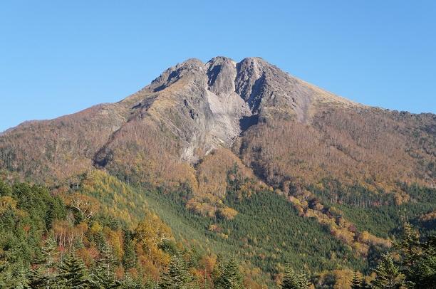
The summit of Nikko-Shirane Volcano
Nikko-Shirane Volcano is an active volcano on the border between Gunma and Tochigi prefectures. The largest eruption on historic record occurred in 1649 AD. A lava dome forms the three peaks of the summit, and consists of lavas erupted before the 6th century. In 1649 AD, explosions from the eruptive vent opened up a pit between the center and right peaks on the southeastern side (not visible from this view). We conducted trench surveys at six sites to clarify underlying pyroclastic fall deposits at less than 1 km from the summit, and revealed that Nikko-Shirane Volcano erupted at least three times since the 6th century. A view of the peak from WNW. Photo taken on October, 2015.
(Photograph and Caption by KUSANO Yuki)
Table of Contents
All the pages PDF : 71_01_full.pdf [19MB]
| Title | Author | |
|---|---|---|
| Article | ||
| Eruptive history in the last 1400 years of Nikko-Shirane Volcano based on trench surveys |
KUSANO Yuki and ISHIZUKA Yoshihiro (p1-18)
|
71_01_01.pdf [3.5MB] |
| Re-examination of the stratigraphy of the Tokyo Formation at the type core section in the Yoyogi Park, Tokyo, central Japan |
NAKAZAWA Tsutomu, NAYA Tomonori, SAKATA Kentaro, HONGO Misao, SUZUKI Takehiko and
NAKAYAMA Toshio (p19-32)
|
71_01_02.pdf [5.2MB] |
| Reports | ||
| LA–ICP–MS zircon U–Pb ages of felsic tuffaceous beds in the Takikubo and Horita formations, Izumi Group, Ikeda district, eastern Shikoku, southwestern Japan |
NODA Atsushi, DANHARA Tohru, IWANO Hideki and HIRATA Takafumi(p33-48)
|
71_01_03.pdf [8MB] |
| Note and Comment | ||
| Critical taper model - Introduction from soil mechanics |
KOGE Hiroaki and NODA Atsushi (p49-61)
|
71_01_04.pdf [1.8MB] |
Abstract
Eruptive history in the last 1400 years of Nikko-Shirane Volcano based on trench surveys
KUSANO Yuki and ISHIZUKA Yoshihiro
The eruptive history of Nikko-Shirane Volcano in the last 1400 years is revealed by observations from six trench survey sites and a drilling core sampled from Japan Meteorological Agency (JMA)’s borehole type volcano monitoring station located at less than 0.4 to 1.7 kilometers from the summit. We have detected three pyroclastic fall deposits derived from Nikko-Shirane Volcano in the last 1400 years based on the features of their stratigraphy, thickness, grain size, radiocarbon ages and modal compositions; A, B and C pyroclastic fall deposits of Nikko-Shirane Volcano in order from youngest to oldest. The A pyroclastic fall deposit can be correlated to the 1649 AD eruption. The B pyroclastic fall deposit directly overlies a foreign tephra derived from Asama Volcano (Asama-B tephra) of early 12th century age. The C pyroclastic fall deposit overlies thin soils and another foreign tephra derived from Haruna Volcano (Haruna-Futatsudake-Ikaho tephra) of middle 6th century age. The stratigraphic relations and four radiocarbon dates for soil layers show that the C pyroclastic fall deposit was derived from an eruption during the middle 7th to early 8th century. Based on the thickness, and grain size of ash, lapilli and volcanic blocks included in A, B and C pyroclastic fall deposits around the summit, the eruption magnitude of the middle 7th to early 8th century was larger than the 1649 AD eruption, which is the largest one of the historical eruption record of Nikko-Shirane Volcano.
Re-examination of the stratigraphy of the Tokyo Formation at the type core section in the Yoyogi Park, Tokyo, central Japan
NAKAZAWA Tsutomu, NAYA Tomonori, SAKATA Kentaro, HONGO Misao, SUZUKI Takehiko and NAKAYAMA Toshio
The stratigraphy of the Tokyo Formation at the type core section in the Yoyogi park, Tokyo, central Japan is reexamined based on the sedimentary facies and tephro- and palyno-stratigraphy. Sedimentological study of the type core section and geotechnical borehole data analysis reveal that the Tokyo Formation can be divided into the lower incised-valley fills and the upper flattened, widespread marine sand bed. These constitute a depositional cycle formed during a series of transgression and regression. The Tokyo Formation is covered with the Shimosueyoshi Loam intercalating a KlP tephra layer (late MIS 5e). Pollen assemblages in the lower part of the Tokyo Formation are comparable with those of early to middle MIS 5e in the off Kashima seafloor core. Therefore, the Tokyo Formation at the type core section is considered to have been mainly deposited during MIS 5e and can be correlated with the Kioroshi Formation in the northern Chiba area and the succession of the Setagaya and Tokyo formations in the Setagaya area. However, further stratigraphic examination of the Tokyo Formation is required because it is not necessary equivalent to the strata previously called the Tokyo Formation in other areas of Tokyo.
LA–ICP–MS zircon U–Pb ages of felsic tuffaceous beds in the Takikubo and Horita formations, Izumi Group, Ikeda district, eastern Shikoku, southwestern Japan
NODA Atsushi, DANHARA Tohru, IWANO Hideki and HIRATA Takafumi
Laser ablation–inductively coupled plasma–mass spectrometry zircon U–Pb ages were acquired for three felsic tuffaceous beds, one from the upper Takikubo Formation (sample IT01) and two from the lower Horita Formation (IT02 and IT03), to determine depositional ages of the Izumi Group in the Ikeda district, eastern Shikoku, southwestern Japan. The weighted mean 206Pb/238U ages and 2σ errors are 78.3 ± 1.3 Ma (IT01), 80.8 ± 1.2 Ma (IT02), and 79.3 ± 1.1 Ma (IT03). Two of the three ages (78.3 ± 1.3 Ma and 79.3 ± 1.1 Ma) passed the χ2 red (reduced) statistical test, but the other (80.8 ± 1.2 Ma) failed. These U–Pb ages indicate that the maximum depositional age of the Izumi Group in this district is middle Campanian (magnetostratigraphic chron C33n). These ages are similar to those reported from the lower Takikubo Formation in the Kan-onji district (80.8–78.3 Ma). Although an apparent stratigraphic thickness from the lower Takikubo Formation to the lower Horita Formation reaches 12 km, there is no younging trend of the zircon U–Pb ages through these formations. This suggests that either the sedimentation rate of the Izumi Group was high or there was a lack of volcanic activity that could produce new zircon crystals in the hinterland during deposition of the succession.
Critical taper model - Introduction from soil mechanics
KOGE Hiroaki and NODA Atsushi
Critical taper model was based on soil mechanics and devised to explain the relationship among the prism form of the fold-and-thrust belt or the accretionary wedge and the friction of the décollement. With this mechanical model, regarding the friction of the décollement, we can discuss (1) the comparison of each subduction zones, (2) the spatial distribution within a single subduction zone, or (3) the time change of single cross-section. However, this critical taper model has few users in the geological research in Japan. This might be because that critical taper is needed to learn soil mechanics, which is mainly used in the field of civil engineering in Japan, or there is almost no detailed review written in Japanese. In this paper, in order to help for the understanding of critical taper model, first, we introduce critical taper model from the basics of Mohr-Coulomb failure criteria in soil mechanics and show how it was used and calculated in three cases.
Geological Survey of Japan, AIST
- About GSJ
- Our Activities
- Purchase guide
-
Publications and Database
- information
-
Bulletin of the Geological Survey of Japan
- bull2026(Vol.77)
- bull2025(Vol.76)
- bull2024(Vol.75)
- bull2023(Vol.74)
- bull2022(Vol.73)
- bull2021(Vol.72)
- bull2020(Vol.71)
- bull2019(Vol.70)
- bull2018(Vol.69)
- bull2017(Vol.68)
- bull2016(Vol.67)
- bull2015(Vol.66)
- bull2014(Vol.65)
- bull2013(Vol.64)
- bull2012(Vol.63)
- bull2011(Vol.62)
- bull2010(Vol.61)
- bull2009(Vol.60)
- bull2008(Vol.59)
- bull2007(Vol.58)
- bull2006(Vol.57)
- bull2005(Vol.56)
- bull2004(Vol.55)
- bull2003(Vol.54)
- bull2002(Vol.53)
- bull2001(Vol.52)
- Bulletin of the Geological Survey of Japan(old)
- Annual Report on Active Fault and Paleoearthquake Researches
- Reports, Geological Survey of Japan
- CCOP-GSJ Groundwater Project Report
- CCOP Technical Bulletin
- Cruise Report
- Geological Hazards
- Learning and Education
- GSJ Database Collection
- Collection of links