Bulletin of the Geological Survey of Japan Top Page
Bulletin of the Geological Survey of Japan Vol.70 No.4 (2019)
Cover photograph | Table of Contents | Abstract
Cover photograph
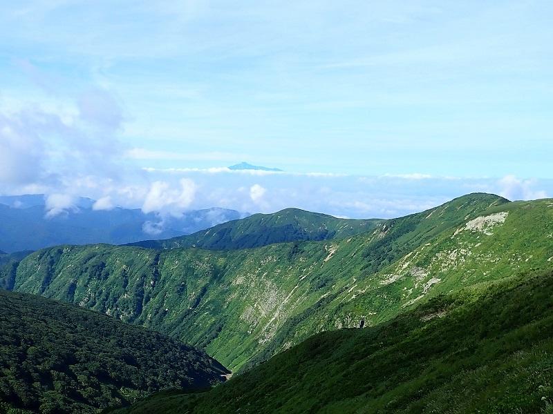
Mt. Yakushidake and surrounding mountains composed of the Neogene Mahirugawa Formation
The Neogene Mahirugawa Formation is widely distributed over the Ou Backbone Range in the Kakunodate district. The Neogene formations in the central Ou Backbone Range tend to form deep eroded valleys, which are also seen in the Mahirugawa Formation in the Kakunodate district (see the photo). Little information has been obtained about the age of the Mahirugawa Formation because it mainly consists of altered volcanic rocks. The peak in the distance is Mt. Chokai.
(Photograph and Caption by Jun Hosoi)
Table of Contents
All the pages PDF : 70_04_full.pdf [6MB]
| Title | Author | |
|---|---|---|
| Article | ||
| The age of the Mahirugawa Formation distributed in the Ou Backbone Range, the east of Kakunodate Town, Akita Prefecture, northeast Japan | Jun Hosoi, Takashi Kudo, Hideki Iwano, Tohru Danhara and Takafumi Hirata (p315-326) | 70_04_01.pdf [5.2MB] |
| Notes and Comments | ||
| The changes of well water and sea level witnessed on the coast of the Kii peninsula prior to the 1946 Nankai earthquake | Yasuhiro Umeda and Satoshi Itaba (p327-334) | 70_04_02.pdf [651KB] |
Abstract
The age of the Mahirugawa Formation distributed in the Ou Backbone Range, the east of Kakunodate Town, Akita Prefecture, northeast Japan
Jun Hosoi, Takashi Kudo, Hideki Iwano, Tohru Danhara and Takafumi Hirata
The Miocene strata widely distributed in the Ou Backbone Range on the east of the Kakunodate Town are mainly composed of volcanic rocks, whose geochronological data are very few. In this study, we conducted U–Pb and FT double dating of zircons obtained from the lower and upper part of the Miocene Mahirugawa Formation. The lower Mahirugawa Formation is dated at 13.2 ± 0.6 Ma and the upper is dated at 13.7 ± 0.3 Ma. The result shows that the boundary age of the Mahirugawa Formation and the younger Uchizawagawa Formation is ca. 14–13 Ma. Judging from their age and lithofacies, they seem to be correlated with the Nishikurosawa Formation in the standard stratigraphic succession in the Akita area.
The changes of well water and sea level witnessed on the coast of the Kii peninsula prior to the 1946 Nankai earthquake
Yasuhiro Umeda and Satoshi Itaba
Abnormal phenomena observed on the coast of the Kii Peninsula prior to the 1946 Nankai earthquake were collected and examined. Most of the information was acquired from literature and some testimonies were obtained by interview with residents. Water level lowering and/or turbidity of well water was witnessed two or three days before the main shock. Land subsidence had been observed on the eastern coast of the Kii Peninsula. The subsidence is thought to be the post-seismic deformation of the 1944 Tonankai earthquake. Oscillatory sea level changes which were witnessed in some areas suggests that a tsunami might have occurred. Testimonies by some residents that they had heard roaring sound and/or felt tremor prior to the main shock were also recorded.
Geological Survey of Japan, AIST
- About GSJ
- Our Activities
- Purchase guide
-
Publications and Database
- information
-
Bulletin of the Geological Survey of Japan
- bull2026(Vol.77)
- bull2025(Vol.76)
- bull2024(Vol.75)
- bull2023(Vol.74)
- bull2022(Vol.73)
- bull2021(Vol.72)
- bull2020(Vol.71)
- bull2019(Vol.70)
- bull2018(Vol.69)
- bull2017(Vol.68)
- bull2016(Vol.67)
- bull2015(Vol.66)
- bull2014(Vol.65)
- bull2013(Vol.64)
- bull2012(Vol.63)
- bull2011(Vol.62)
- bull2010(Vol.61)
- bull2009(Vol.60)
- bull2008(Vol.59)
- bull2007(Vol.58)
- bull2006(Vol.57)
- bull2005(Vol.56)
- bull2004(Vol.55)
- bull2003(Vol.54)
- bull2002(Vol.53)
- bull2001(Vol.52)
- Bulletin of the Geological Survey of Japan(old)
- Annual Report on Active Fault and Paleoearthquake Researches
- Reports, Geological Survey of Japan
- CCOP-GSJ Groundwater Project Report
- CCOP Technical Bulletin
- Cruise Report
- Geological Hazards
- Learning and Education
- GSJ Database Collection
- Collection of links