Bulletin of the Geological Survey of Japan Top Page
Bulletin of the Geological Survey of Japan Vol.69 No.2 (2018)
Cover photograph | Table of Contents | Abstract
Cover photograph
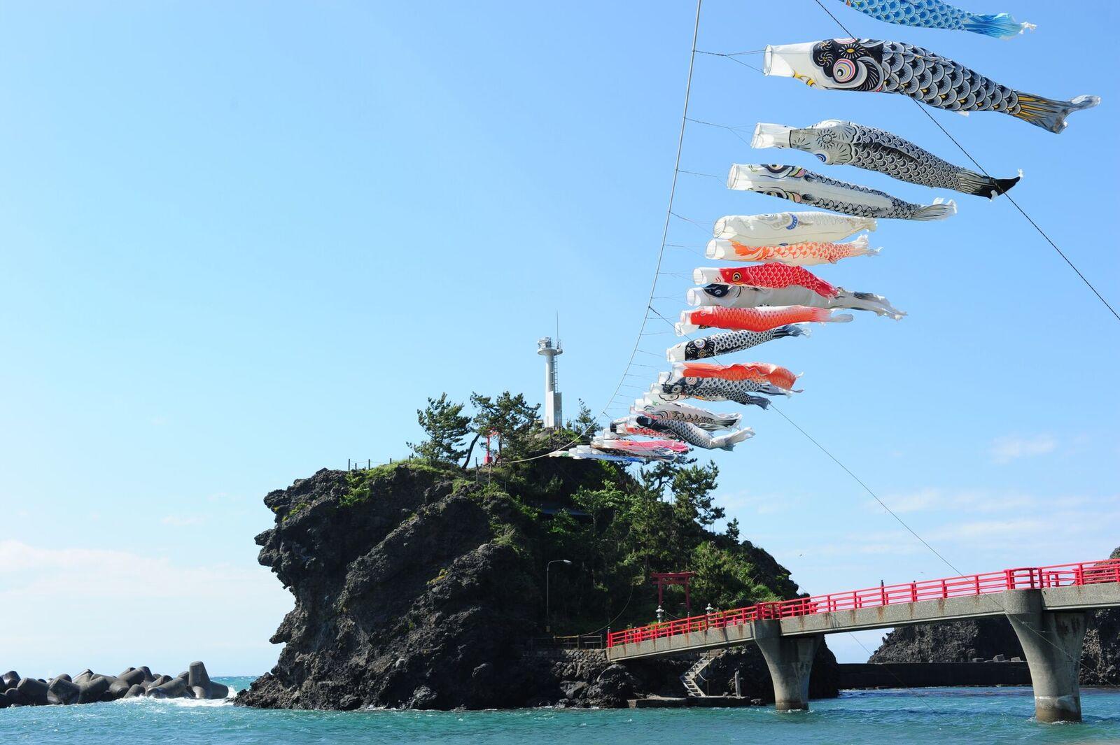
Benten-iwa, No Coast, Niigata Prefecture
The Benten-iwa is the name of a small rock reef off the No Coast, east of the Itoigawa City, Niigata Prefecture.
There is the Itsukushima Shrine worshipping the goddess of the sea atop the rock where a lighthouse stands beside.
The volcaniclastic rocks of the Benten-iwa are part of a submarine volcanic edifice which was active around 1 Ma,
the Early Pleistocene. These volcaniclastics are correlated with those of the Eboshiyama Formation distributed around
the Mt. Eboshi. The Benten-iwa is one of the geosites of the Itoigawa UNESCO Global Geopark.
Locality of the Benten-iwa: 37°6′32.4″N,137°59′34″E.
(Photograph by Ryuta Furukawa, Caption by Hideaki Nagamori)
Table of Contents
All the pages PDF : 69_2_full.pdf [23MB]
| Title | Author | |
|---|---|---|
| Article | ||
| Estimation of time series of the vertical deformations using the sea level changes at the 1944 Tonankai and the 1946 Nankai earthquakes on the coastal area of Kii peninsula |
Yasuhiro Umeda and Satoshi Itaba (p81-89)
|
69_02_01.pdf [586KB] |
| Optimization of analytical conditions for major element analysis of geological samples with XRF using glass beads |
Masatsugu Ogasawara, Masumi Mikoshiba, Nobuo Geshi, Gen Shimoda and Yoshihiro Ishizuka (p91-103)
|
69_02_02.pdf [518KB] |
| Reports | ||
| Change of the light nonmethane hydrocarbon blank values in tap water by water pipe renewal works |
Shunichiro Igari (p105-114)
|
69_02_03.pdf [728KB] |
| Pleistocene volcanic rocks from the eastern Itoigawa Region |
Ryuta Furukawa and Hideaki Nagamori (p115-124)
|
69_02_04.pdf [5.2MB] |
| Notes and Comments | ||
| Detrital zircon U–Pb age of sandstone within the Jurassic accretionary complex in the Omori area, northeastern Shimokita Peninsula, Northeast Japan |
Takayuki Uchino (p125-133)
|
69_02_05.pdf [3.3MB] |
| Method for making high-quality thin sections of native sulfur |
Takayuki Sawaki, Akira Owada and Eri Hirabayashi (p135-139)
|
69_02_06.pdf [1.7MB] |
Abstract
Estimation of time series of the vertical deformations using the sea level changes at the 1944 Tonankai and the 1946 Nankai earthquakes on the coastal area of Kii peninsula
Yasuhiro Umeda and Satoshi Itaba
On the coastal area of Kii peninsula, there is no levering data just before the 1944 Tonankai and 1946 Nankai earthquakes, because the levering by Geospatial Information Authority of Japan have been carried out around 1930 and 1947. Therefore, it has been impossible to separate the vertical deformations caused by each earthquake. The co-seismic vertical changes of both earthquakes were obtained from the sea level changes at the time of both earthquakes by the Hydrographic Bureau. The time series of the vertical deformations before and after both earthquakes were obtained by combining two kinds of data by two institutes. The southeastern area of Kii peninsula subsided at the time of the 1944 Tonankai earthquake and the subsidence continued until the 1946 Nankai earthquake. The upheaval by the 1946 Nankai earthquake recovered the amount of subsidence before the earthquake. Because the tide station of Kushimoto was broken by the 1946 Nankai earthquake, it was impossible to connect the sea level data before and after the earthquake. The vertical deformation was obtained by subtracting the long term change in mean sea level from the yearly average sea level. The continuous vertical deformation was obtained by superimposing the deformation thus obtained on the time series by the leveling at Kushimoto.
Optimization of analytical conditions for major element analysis of geological samples with XRF using glass beads
Masatsugu Ogasawara, Masumi Mikoshiba, Nobuo Geshi, Gen Shimoda and Yoshihiro Ishizuka
The major element XRF analytical program, Bead03, has been prepared for geological samples. The analytical condition suitable for the samples was optimized considering sensitivity, precision, and the lower limit of detection. The detailed analytical protocol of Bead03 has been described, and Bead03 has been successfully used at the shared facility of the GSJ laboratory. Bead03 is generally used without the need for frequent calibration. As such, any user can perform analysis with a minimum number of steps and simple operation. Bead03 can also 1) perform overlapping correction of Br Lα on Al Kα, eliminating the effect of releasing agent LiBr, and 2) apply curve fitting of backgrounds for Na Kα and Mg Kα. The present report also describes the quality of calibration lines for silicate rock samples and analytical precision.
Change of the light nonmethane hydrocarbon blank values in tap water by water pipe renewal works
Shunichiro Igari
We proposed a method to measure light nonmethane hydrocarbon content in the atmosphere using distilled water, which was heated and cooled down to room temperature, in 2015. However, tap water, which distilled water is made from, originally contains some amount of light nonmethane hydrocarbons and they are not completely removed by a distilling apparatus. Since it is necessary to carefully consider the pollution by a minute amount of organic matter particularly in organic geochemistry, knowing their content in tap water is very important. In January 2015, waterpipes in a building of the National Institute of Advanced Industrial Science and Technology were replaced. We measured the blank values of light nonmethane hydrocarbons in the tap water before and after the renewal work. The value increased after the renewal work and then decreased gradually. But it did not recover to the prior level after half a year. The relation between the blank values and sampling intervals was also investigated. It is clarified that the longer the flushing interval is, the lower the blank value becomes. This means flushing a large volume of water before the use is effective to temporarily reduce the content of light nonmethane hydrocarbons.
Pleistocene volcanic rocks from the eastern Itoigawa Region
Ryuta Furukawa and Hideaki Nagamori
Volcanic stratigraphy performed at the eastern Itoigawa region revealed 3 formations of volcanic rocks of Sarukura, Eboshiyama and Takanomine in ascending order, with subordinating coarse grained epiclastic formation of Kajiyashiki which is partly interfingered with the Takanomine Formation. K–Ar datings revealed ca. 1.3–1.2 Ma from juvenile dacite volcanic blocks of the Eboshiyama Formation and 0.65 Ma from juvenile andesite volcanic block of the Takanomine Formation. Fission-Track dating resulted in ca. 1 Ma from the Otanigawa Tuff of the Kajiyashiki Formation. As the Kajiyashiki Formation includes abundant andesite volcanic blocks of the Takanomine Formation, the activity of the Takanomine Formation started before 1 Ma and at least sustained until 0.65 Ma. Petrological analyses revealed characteristics of magma in each formation especially shown in SiO2–K2O diagram which depicts discriminative variation of K-series in Pleistocene epoch.
Detrital zircon U–Pb age of sandstone within the Jurassic accretionary complex in the Omori area, northeastern Shimokita Peninsula, Northeast Japan
Takayuki Uchino
Jurassic accretionary complexes, which are basement rocks lying under the Neogene sediments, in the northeastern part of the Shimokita Peninsula of the Northeast Japan, are separately distributed in the Kuwahatayama, Katasakiyama and Omori areas from the north. Although latest Jurassic to earliest Cretaceous radiolarian ages have been reported from the mudstone in Cape Shiriya in the Kuwahatayama area, no geologic ages have been reported from the accretionary complexes in the Katasakiyama and Omori areas. The U–Pb ages of detrital zircon from sandstone in the Omori area were examined in this study. Consequently, 154.7 ± 1.5 Ma (1σ) was obtained as a weighted mean age of the youngest cluster. Therefore, it has been confirmed that the sandstone was deposited after Late Jurassic.
Method for making high-quality thin sections of native sulfur
Takayuki Sawaki, Akira Owada and Eri Hirabayashi
This paper proposes a method for making high-quality thin sections of native sulfur (i.e., highly transparent and with a very smooth surface) that are suitable for microscopic observation in mineralogical studies. Generally, native sulfur is too fragile and too easily altered by heating to prepare thin sections for mineralogical study using conventional methods. The proposed method combines dry and wet polishing methods with a special abrasive made of zeolite powder. Using this method, 30-μm-thick sections of native sulfur can be made. The proposed method allows more detailed geochemical and mineralogical studies of volcanic and geothermal fluids and sedimentary environments.
Geological Survey of Japan, AIST
- About GSJ
- Our Activities
- Purchase guide
-
Publications and Database
- information
-
Bulletin of the Geological Survey of Japan
- bull2026(Vol.77)
- bull2025(Vol.76)
- bull2024(Vol.75)
- bull2023(Vol.74)
- bull2022(Vol.73)
- bull2021(Vol.72)
- bull2020(Vol.71)
- bull2019(Vol.70)
- bull2018(Vol.69)
- bull2017(Vol.68)
- bull2016(Vol.67)
- bull2015(Vol.66)
- bull2014(Vol.65)
- bull2013(Vol.64)
- bull2012(Vol.63)
- bull2011(Vol.62)
- bull2010(Vol.61)
- bull2009(Vol.60)
- bull2008(Vol.59)
- bull2007(Vol.58)
- bull2006(Vol.57)
- bull2005(Vol.56)
- bull2004(Vol.55)
- bull2003(Vol.54)
- bull2002(Vol.53)
- bull2001(Vol.52)
- Bulletin of the Geological Survey of Japan(old)
- Annual Report on Active Fault and Paleoearthquake Researches
- Reports, Geological Survey of Japan
- CCOP-GSJ Groundwater Project Report
- CCOP Technical Bulletin
- Cruise Report
- Geological Hazards
- Learning and Education
- GSJ Database Collection
- Collection of links