Bulletin of the Geological Survey of Japan Top Page
Bulletin of the Geological Survey of Japan Vol.64 No.5/6 (2013)
Cover photograph | Table of Contents | Abstract
Cover photograph
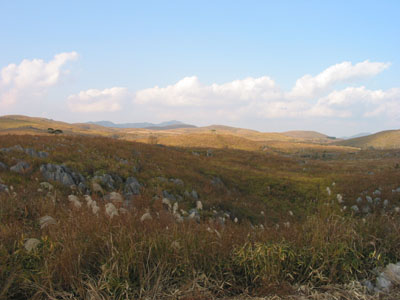 Akiyoshi-dai in autumn
The Japanese geochemical map is the regional spatial distribution pattern of elemental concentrations that was created using about 3000 stream sediment samples and published in 2004. For a comprehensive survey of regional spatial distribution pattern of elemental concentrations both in terrestrial and marine environment, marine geochemical map was further produced after five years. The spatial distribution patterns of elemental concentrations of stream sediments reflect faithfully the distribution of geology and mineral deposits. However, the exception is limestone bedrock. The stream sediments derived from a large-scale limestone bedrock were significantly poorer in calcium and strontium than other sediments. Stream sediments were sampled from Akiyoshi-dai in Yamaguchi Prefecture, where is underlain by the largest-scale limestone bedrock region was selected to elucidate the particle transfer process in limestone region. I took photograph in Akiyoshi-dai from the Akiyoshi-dai karst observation platform after sampling. A Japanese silver grass swing by wind lets you fell autumn of Akiyoshi-dai.
(Photograph and Caption by Atsuyuki Ohta)
Table of Contents
All the pages PDF : 64_05_full.pdf [48.4MB]
| Title | Author | |
|---|---|---|
| Article | ||
| Less impact of limestone bedrock on elemental concentrations in stream sediments – Case study of Akiyoshi area – |
Atsuyuki Ohta and Masayo Minami (121 - 138) |
64_05_01.pdf [3.1MB] |
| Observation of radionuclides transported with aerosols at the GSJ in 2012 and re-examination of meteorological factors | Yutaka Kanai, Taeko Doi and Kazuyoshi Masumoto (139 − 150) |
64_05_02.pdf [3.1MB] |
| Report | ||
| Triassic to Middle Jurassic radiolarians from pelagic cherts in the Nanjō Mountains, Southwest Japan – Part 2. Kanmuri Yama district |
Satoshi Nakae (151-190) |
64_05_03.pdf [42.3MB] |
Abstract
Less impact of limestone bedrock on elemental concentrations in stream sediments
– Case study of Akiyoshi area –
Atsuyuki Ohta and Masayo Minami
Geological survey of Japan, National Institute of Advanced Industrial Science and Technology has created the nationwide geochemical maps of 53 elements using fine stream sediments (< 180 μm) inJapan. The spatial distribution patterns of elemental concentrations of stream sediments reflect faithfully the distribution of geology and mineral deposits. However, the exception is limestone bedrock, which insignificantly influences on elemental concentrations of stream sediments. To clarify the reason, we collected stream sediments from Akiyoshi-dai, where is underlain by the largest-scale limestone bedrock.Fine stream sediments (< 180 μm), whose drainage basins are occupied by limestones, have high CaO and Sr concentrations and intensive peak of calcite obtained by X-ray diffractometry. Examining variation of elemental concentrations against the particle size of sediments, the finer particle contains a higher proportion of calcite and has higher CaO concentration. However, CaO concentration (10–20 wt. %) in stream sediments is much lower than expected values (~50%); nevertheless limestone outcrops in more than 70% in their watersheds. The contradictory finding is explained by less contribution of limestone clastics to river system because limestone bedrocks are easily dissolved by water (chemical weathering) but not susceptible to physical weathering and erosion process. In other words, the supply quantity of clastic materials from limestone bedrocks is much smaller than those of other rock types. In addition, Sr concentration in some samples does not correlate with either CaO concentration or the peak intensity of calcite; nevertheless Sr is expected to have similar chemical properties to CaO. The fact suggests that calcite formed from water oversaturated for calcium carbonate is supplied to river system; it has the different Sr concentrations from Akiyoshi Limestone.
Observation of radionuclides transported with aerosols at the GSJ in 2012 and re-examination of meteorological factors
Yutaka Kanai, Taeko Doi and Kazuyoshi Masumoto
In order to obtain the geochemical knowledge of material cycle as a tracer and to contribute
the concern of inhabitant about safety after the accident of the Fukushima Dai-ichi Nuclear Power Plant(FDNPP), the aerosol observation at the GSJ was continued and the new data in 2012 are reported in this paper.
The Cs radioisotope concentrations in the air decreased from April 2012 when the southerly wind often blew instead of northerly wind and rainy day increased. Several increases in the observed concentration were ascribed to the re-suspension of deposited particles by strong wind. The meteorological effect on variation of Cs-137 concentration in 2011 was re-examined in this study by the use of back trajectory analysis, which clarified that the air mass which had passed over the FDNPP arrived at the GSJ when the high concentration was observed. Measurement of the samples with known concentration showed that there seemed to be no problem on measurement system in this study.
Triassic to Middle Jurassic radiolarians from pelagic cherts in the Nanjō Mountains, Southwest Japan
– Part 2. Kanmuri Yama district
Satoshi Nakae
The Nanjō Mountains located in the central region of Fukui Prefecture, Southwest Japan, are chiefly underlain by the sedimentary complex of various rock-types such as basalt, limestone, chert, mudstone and sandstone. Among these rocks within the mountains, twenty-seven chert outcrops (localities) were explored for their radiolarian content. Twenty-six rock samples from seventeen localities in the studied Kanmuri Yama district yielded moderately- to poorly-preserved radiolarian remains as a result. Most of the samples contain Triassic to Middle Jurassic species, with Spumellaria and Entactinaria dominant among the Triassic faunas and with Nassellaria dominant among the Jurassic faunas. The description and faunal analysis of these radiolarians revealed that the cherts in the Kanmuri Yama district span a wide range of age from the Late Olenekian to Middle Bathonian stages.
Geological Survey of Japan, AIST
- About GSJ
- Our Activities
- Purchase guide
-
Publications and Database
- information
-
Bulletin of the Geological Survey of Japan
- bull2026(Vol.77)
- bull2025(Vol.76)
- bull2024(Vol.75)
- bull2023(Vol.74)
- bull2022(Vol.73)
- bull2021(Vol.72)
- bull2020(Vol.71)
- bull2019(Vol.70)
- bull2018(Vol.69)
- bull2017(Vol.68)
- bull2016(Vol.67)
- bull2015(Vol.66)
- bull2014(Vol.65)
- bull2013(Vol.64)
- bull2012(Vol.63)
- bull2011(Vol.62)
- bull2010(Vol.61)
- bull2009(Vol.60)
- bull2008(Vol.59)
- bull2007(Vol.58)
- bull2006(Vol.57)
- bull2005(Vol.56)
- bull2004(Vol.55)
- bull2003(Vol.54)
- bull2002(Vol.53)
- bull2001(Vol.52)
- Bulletin of the Geological Survey of Japan(old)
- Annual Report on Active Fault and Paleoearthquake Researches
- Reports, Geological Survey of Japan
- CCOP-GSJ Groundwater Project Report
- CCOP Technical Bulletin
- Cruise Report
- Geological Hazards
- Learning and Education
- GSJ Database Collection
- Collection of links