Bulletin of the Geological Survey of Japan Top Page
Bulletin of the Geological Survey of Japan Vol.63 No.5/6 (2012)
Cover photograph | Table of Contents | Abstract
Cover photograph
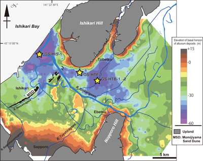
Contour map of the basal horizon of the latest Pleistocene to Holocene incised-valley fill deposits (called the Chuseki-so in Japan) in the Ishikari lowland
The Ishikari lowland is underlain by the thick Chuseki-so representing Japan. We have produced the contour map of the basal horizon of the Chuseki-so, based on the borehole database, which consists of borehole log data that a government organization and local self-governments such as Hokkaido Prefecture and Sapporo City. The elevation level and soil classification of each borehole data have been checked for the quality identification of data.
The contour map demonstrates that R. Ishikarigawa was flowing through the south margin of the Ishikari hill during the Last Maximum Glacial. In addition, it figures out the geomorphologic feature of buried fluvial fans formed by both R.Toyohiragawa and R. Hassamugawa, and north-directed three-lined rises in the northern Sapporo City. In respect of a position, these rises can be correlated to the Tsukisamu, Barato and NishiSapporo anticlines, respectively.
(Fig and Caption by Wataru Hirose, Gentaro Kawakami, Sunao Ohtsu and Katsumi Kimura)
Table of Contents
All the pages PDF : 63_05_full.pdf [26.5MB]
| Title | Author | |
|---|---|---|
| Article | ||
| Stratigraphic and sedimentologic analysis of the latest Pleistocene to Holocene sediment core GS-HIS-1 recovered from the Ishikari coastal plain, Oyafune, Ishikari, Hokkaido, Japan (This article is in Japanese, with English abstract.) |
Gentaro Kawakami, Ayako Funabiki, Tsumoru Sagayama, Rei Nakashima, Kenji Nishina,
Wataru Hirose, Sunao Ohtsu, Yousuke Isomae and Katsumi Kimura (129-146) |
63_05_01.pdf [21.5MB] |
| Note and Comment | ||
| Identification of marine sediments inferred from diatom fossil and lithofacies in the drillcores in central Kanto Plain, Japan (This article is in Japanese, with English abstract.) |
Tomonori Naya, Shoichi Hachinohe, Hiroko Matsushima and Kiyohide Mizuno (147-180)
|
63_05_02.pdf [5.4MB] |
Abstract
Stratigraphic and sedimentologic analysis of the latest Pleistocene to Holocene sediment core GS-HIS-1 recovered from the Ishikari coastal plain, Oyafune, Ishikari, Hokkaido, Japan
Gentaro Kawakami, Ayako Funabiki, Tsumoru Sagayama, Rei Nakashima, Kenji Nishina, Wataru Hirose, Sunao Ohtsu, Yousuke Isomae and Katsumi Kimura
The stratigraphy and sedimentary facies of the latest Pleistocene to Holocene incised-valley fills were analyzed at Oyafune, Ishikari, in the Ishikari coastal plain, Hokkaido, northern Japan. A core sample, named GS-HIS-1, was obtained at a site in the present strand plain, where the axis of the paleo-Ishikari River valley was located in the Last Glacial Age. The core sediments can be divided into seven stratigraphic units: flood-plain deposits (Unit 1), gravelly river deposits (Unit 2), meandering river and tidal river / salt marsh deposits (Unit 3), inner-bay deposits (Unit 4), lower-shoreface deposits (Unit 6), lagoonal deposits (Unit 7), and upper-shoreface to foreshore / backshore deposits (Unit 8), in ascending order.
The lower shoreface sands (Unit 6) erosively overlie the inner-bay deposits (Unit 4), and the erosive boundary is considered to be a wave ravinement surface. Delta-front / delta-plain deposits (Unit 5 in Kawakami et al., 2012a; b) on inner-bay deposits in inland area are absent at the drilling site. Units 6 – 8 constitute a prograding sand body, which was formed after the mid-Holocene sea-level highstand. The muddy deposits (Unit 7) intercalated with this sand body yield abundant freshwater diatom species, and they were probably deposited in a lagoonal fluvial channel running parallel to the shoreline. The channel would have been rapidly buried as a result of shore progradation.
The sediment accumulation curve provides information on the timing of periods of environmental change at the studied site. As the sea level rose, the sedimentary system changed from a gravelly river to a meandering sandy river at about 13,000 cal BP. The river was influenced by marine water intrusion after 10,600 cal BP, and the inner-bay environment was generated around 8,900 cal BP. The shallow marine sands prograded onto the wave ravinement surface after 5,300 cal BP.
Identification of marine sediments inferred from diatom fossil and lithofacies in the drillcores in central Kanto Plain, Japan
Tomonori Naya, Shoichi Hachinohe, Hiroko Matsushima and Kiyohide Mizuno
Number and depth of marine intervals in seven drillcores in central Kanto Plain, central Japan, were examined by diatom fossil analysis and lithofacies observations. The numbers of identified marine intervals in seven drillcores are as follows; 15 marine intervals (TZ-M1 – TZ-M15) in Tokorozawa core, six marine intervals (WM-M1 – WM-M6) in Washimiya core, three marine intervals (GD-M1 – GD-M3) in Gyoda core, 12 marine intervals (KGH-M1 – KGH-M12) in Koshigaya-Higashi core, 14 marine intervals (KJ-M1 – KJ-M14) in Kawajima core, 18 marine intervals (KK-M1 – KK-M18) in Kasukabe core and eight marine intervals (FS-M1 – FS-M8) in Fukasaku A-1 core. These results present basic stratigraphic data to develop the Quaternary subsurface stratigraphy of central Kanto Plain.
Geological Survey of Japan, AIST
- About GSJ
- Our Activities
- Purchase guide
-
Publications and Database
- information
-
Bulletin of the Geological Survey of Japan
- bull2026(Vol.77)
- bull2025(Vol.76)
- bull2024(Vol.75)
- bull2023(Vol.74)
- bull2022(Vol.73)
- bull2021(Vol.72)
- bull2020(Vol.71)
- bull2019(Vol.70)
- bull2018(Vol.69)
- bull2017(Vol.68)
- bull2016(Vol.67)
- bull2015(Vol.66)
- bull2014(Vol.65)
- bull2013(Vol.64)
- bull2012(Vol.63)
- bull2011(Vol.62)
- bull2010(Vol.61)
- bull2009(Vol.60)
- bull2008(Vol.59)
- bull2007(Vol.58)
- bull2006(Vol.57)
- bull2005(Vol.56)
- bull2004(Vol.55)
- bull2003(Vol.54)
- bull2002(Vol.53)
- bull2001(Vol.52)
- Bulletin of the Geological Survey of Japan(old)
- Annual Report on Active Fault and Paleoearthquake Researches
- Reports, Geological Survey of Japan
- CCOP-GSJ Groundwater Project Report
- CCOP Technical Bulletin
- Cruise Report
- Geological Hazards
- Learning and Education
- GSJ Database Collection
- Collection of links