Bulletin of the Geological Survey of Japan Top Page
Bulletin of the Geological Survey of Japan Vol.62 No.5/6 (2011)
Cover photograph | Table of Contents | Abstract
Cover photograph
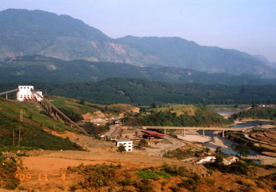
Fault scarf of the Red River Fault at the Sin Quyen mine area, northern Vietnam
The Sin Quyen copper deposits, opened in 2006, are located at the fault scarf of the Red River Fault in the northern Vietnam, which runs from right to left in this picture. The ores are open pitted and transported mostly by belt conveyor system, and chalcopyrite, magnetite and gold are extracted. The ores containing abundant allanite occur as lens shape in mafic metamorphic rocks intruded by granitic dikes. Photographed in autumn 2008.
(Photograph and Caption by Shunso Ishihara)
Table of Contents
All the pages PDF : 62_05_full.pdf [13.9MB]
| Title | Author | |
|---|---|---|
| Article | ||
| Mineralogical and chemical characteristics of the allanite-rich copper and iron ores from the Sin Quyen mine, northern Vietnam. | Shunso Ishihara, Hideo Hirano, Mihoko Hoshino, Pham Ngoc Can, Pham Thi Dung, and Tuan-Anh Tran (197-209) | 62_05_01.pdf [6.2MB] |
| Physical properties of Cretaceous to Paleogene granitic rocks in Japan: Part 4. A case of the inner zone of Southwest Japan. (This article is in Japanese, with English abstract.) | Hiroshi Kanaya and Shigeo Okuma (211-233) | 62_05_02.pdf [2MB] |
| K-Ar ages of adularia at the Koryu epithermal Au-Ag deposit, Hokkaido in Japan. | Toru Shimizu (235-241) | 62_05_03.pdf [1MB] |
| Vertical Crustal Movements along the Pacific Coast of Shikoku before the 1946 Nankai Earthquake. (This article is in Japanese, with English abstract.) | Yasuhiro Umeda and Satoshi Itaba (243-257) | 62_05_04.pdf [3.9MB] |
Abstract
Mineralogical and chemical characteristics of the allanite-rich copper and iron ores from the Sin Quyen mine, northern Vietnam.
Shunso Ishihara, Hideo Hirano, Mihoko Hoshino, Pham Ngoc Can, Pham Thi Dung, and Tuan-Anh Tran
Selected ores from the Sin Quyen allanite-rich Au-bearing chalcopyrite-magnetite deposits were studied microscopically and chemically. The ore minerals tend to occur along the NW-SE-trending sheared zone of altered host rocks; yet the ore minerals show no stress effect, implying the mineralization later than the regional shearing. The ore minerals occur associated with the metasomatic minerals consisting mainly of clinopyroxene, hastingsite, allanite, epidote, biotite, titanite, carbonate minerals and rarely quartz. Allanites containing almost all of the rare earth element (REE) components of the ores occur in disseminated manner and are euhedral to subhedral. The mineral is an early crystallized mineral replaced by magnetite and chalcopyrite. The allanite contains around 16 wt.% REE and is low in mafic components having chemical composition of Mn-poor type, which tends to occur in the magnetite-series granitic rocks in Japan. The REE components could have been derived from an oxidized alkaline granitic activity of mid-Tertiary. Both chalcopyrite and magnetite are well separated by the mineral dressing, and all the allanites moved to the tailings. Therefore, the tailing pond turns out to be an excellent LREE reservoir in future.
Physical properties of Cretaceous to Paleogene granitic rocks in Japan: Part 4. A case of the inner zone of Southwest Japan.
Hiroshi Kanaya and Shigeo Okuma
About 1500 granitic rocks exposed in the inner zone of Southwest Japan were collected and measured on their physical properties such as density, porosity, magnetic susceptibility and Natural Remanent Magnetization (NRM). The results were classified in seven areas (Hokuriku, Chubu, east Kinki, west Kinki, east Chugoku, central Chugoku and north Kyushu) and their geologic time (late Cretaceous: K1-2, K2, Paleogene: PG1, PG2, Neogene: N1, N3) and compared with the same geologic time between each area.
1. Density
The mean density of K1-2 (older Ryoke) of the Chubu area, east Kinki area, and K2 of the north Kyushu ranges 2.72~2.74 (g/cm3=103kg/m3) and that of the PG1 of the Hokuriku area, PG2 of the central Chugoku area shows 2.62.
2. Porosity
The mean porosity shows 0.45% in the east Kinki area K2 (younger Ryoke) and 1.27%, PG2 of the central Chugoku area with the mode of 0.22 to 0.79%. Rock density is inversely proportional to its porosity.
3. Magnetic susceptibility
Magnetic susceptibilities of K1-2 (older Ryoke) and K2 (younger Ryoke) in the Chubu area and K1-2 and K2 in the east Kinki area show lower value of 10-4. Magnetic susceptibilities of the K2 in the Hokuriku area, west Kinki area and central Chugoku area show from 10-4 to 10-3. In addition, those of K2 of the east Chugoku area and north Kyushu area (west part) contain small amount of 10-2 order. Most of Paleogene PG1, PG2 samples show relatively strong magnetic susceptibilities of 10-3 and 10-2 but some show weak susceptibility of 10-4.
4. Density and magnetic susceptibility
Considering the basisity of rocks, measured results are classified by Kanaya and Okuma (2010) into four groups, paramagnetic, low magnetic, medium magnetic and high magnetic. Accepting this classification, granitic rocks K1-2 and K2 of the Chubu and east Kinki areas are defined as paramagnetic to low magnetic zone, K2 of the Hokuriku area, west Kinki area and central Chugoku area contain paramagnetic to medium magnetic samples and K2 of east Chugoku area contains paramagnetic to medium samples and small amount of high magnetic samples.
5. Natural Remanent Magnetization (NRM)
No relationship between the density and NRM is observed but there is a correlation between the magnetic susceptibility and NRM. Königsberger ratio (Qn) of about 90 percent rock samples shows less than 0.4.
These results are summarized in Table 1 (physical properties of Cretaceous to Paleogene granitic rocks in the inner zone of Southwest Japan).
K-Ar ages of adularia at the Koryu epithermal Au-Ag deposit, Hokkaido in Japan.
Toru Shimizu
Four new K-Ar ages of adularia at the Koryu Au-Ag epithermal vein deposit along with the mineralization stages were determined. One age is 1.4 Ma for the first mineralization stage and the other three ages are 1.19-1.10 Ma for the most economically important Au-Ag mineralization stage. Combined with published data of K-Ar ages, mineral description, and fluid inclusion study, the results suggest that the hydrothermal activities waxed and waned, forming ore veins with ten mineralization stages for 0.55 million years in the Koryu deposit.
Vertical Crustal Movements along the Pacific Coast of Shikoku before the 1946 Nankai Earthquake.
Yasuhiro Umeda and Satoshi Itaba
The vertical crustal movement before the 1946 Nankai earthquake was obtained by the leveling of the Geographical Survey Institute(GSI). In Shikoku district, however, the leveling was carried out 7 years before the earthquake. The Hydrographic Bureau(HB) surveyed the co-seismic vertical changes and measured the difference between the measurement of last and just after the earthquake, on the bench mark of GSI or HB. The leveling data of GSI were obtained the Japanese vertical datum origin as a standard, on the contrary, the measurements of HB were obtained based on the mean sea level at each point. The error of latter values has +/ - 0.10 m against that of GSI. The data of co-seismic vertical change have an error of +/ - 0.15 m, because the vales were obtained by viewing of the HB staffs. In the case that the measurement value and co-seismic change are greater than above errors, it is effective to use them with the leveling data. We combined the data of GSI and HB, and obtained the vertical variation curves at 13 points in Shikoku, between 1898 and 1969. The co-seismic upheaval region has subsided in a long term before the earthquake. The co-seismic subsidence region has up heaved gradually about 15 years before the earthquake. It seems that the upheaval speed was accelerated just before the earthquake. The variation curves of vertical crustal movement in a long term will become a base when we assume a prediction curve for the next Nankai earthquake.
Geological Survey of Japan, AIST
- About GSJ
- Our Activities
- Purchase guide
-
Publications and Database
- information
-
Bulletin of the Geological Survey of Japan
- bull2026(Vol.77)
- bull2025(Vol.76)
- bull2024(Vol.75)
- bull2023(Vol.74)
- bull2022(Vol.73)
- bull2021(Vol.72)
- bull2020(Vol.71)
- bull2019(Vol.70)
- bull2018(Vol.69)
- bull2017(Vol.68)
- bull2016(Vol.67)
- bull2015(Vol.66)
- bull2014(Vol.65)
- bull2013(Vol.64)
- bull2012(Vol.63)
- bull2011(Vol.62)
- bull2010(Vol.61)
- bull2009(Vol.60)
- bull2008(Vol.59)
- bull2007(Vol.58)
- bull2006(Vol.57)
- bull2005(Vol.56)
- bull2004(Vol.55)
- bull2003(Vol.54)
- bull2002(Vol.53)
- bull2001(Vol.52)
- Bulletin of the Geological Survey of Japan(old)
- Annual Report on Active Fault and Paleoearthquake Researches
- Reports, Geological Survey of Japan
- CCOP-GSJ Groundwater Project Report
- CCOP Technical Bulletin
- Cruise Report
- Geological Hazards
- Learning and Education
- GSJ Database Collection
- Collection of links