Bulletin of the Geological Survey of Japan Top Page
Bulletin of the Geological Survey of Japan Vol.62 No.1/2 (2011)
Cover photograph | Table of Contents | Abstract
Integrated research on subsurface geology in urban area - Part 3 : Sediment core analysis and pH-EC properties on the latest Pleistocene to Holocene incised-valley fills -
Cover photograph
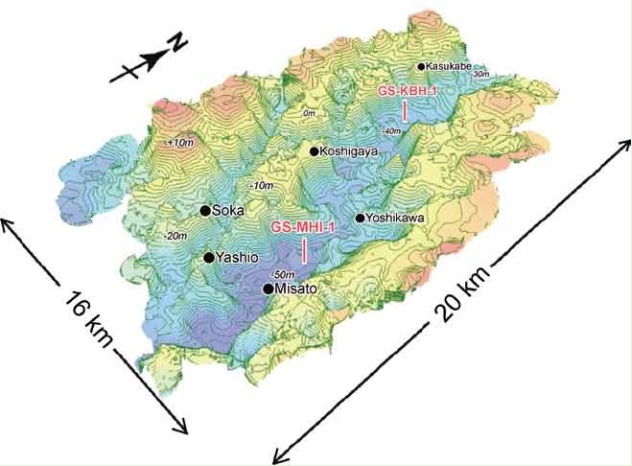
Basal topography of the Chuseki-so in the southern area of the Nakagawa Lowland
The topography was formed due to both the incised-valleys as the results of river channel erosion related to the sea-level lowering during the Last Glacial and the coastal erosion related to the sea-level rising and high-stand. This figure was illustrated by ArcGIS based on the basal depth distribution of the Chuseki-so of about 4000 borehole log data offered from the municipality and the other associations (Nakanishi et al., 2007). The Chuseki-so consists of unconsolidated beds that had been deposited in the fluvial and inner bay environments from the latest Pleistocene to Holocene. See Nakanishi et al. (2011) in this issue for details.
(Photograph and Caption by Toshimichi Nakanishi)
Table of Contents
All the pages PDF : 62_01_full.pdf [15.7MB]
| Title | Author | |
|---|---|---|
| Preface: Urban Geology in Geological Survey of Japan, AIST -Part 3- | Katsumi Kimura(001-002) | 62_01_01.pdf [0.7MB] |
| Article | ||
| Sedimentary facies, diatom assembleages, physical properties and radiocarbon ages of the latest Pleistocene to Holocene incised valley fills under the southern Nakagawa Lowland, Kanto Plain, Japan. | Toshimichi Nakanishi, Susumu Tanabe, Katsumi Kimura, Rei Nakashima, Mieko Uchiyama, Yasuyuki Shibata (003-046) | 62_01_02.pdf [7.4MB] |
| Sedimentary facies, diatom assemblages, physical properties and radiocarbon ages of the latest Pleistocene to Holocene incised valley fills under the central area of the Nakagawa Lowland, Kanto Plain, central Japan. | Toshimichi Nakanishi, Susumu Tanabe, Katsumi Kimura, Rei Nakashima, Mieko Uchiyama, Yasuyuki Shibata (047-084) | 62_01_03.pdf [6.5MB] |
| Electric conductivity and pH profiles of pore water extracted from the latest Pleistocene to Holocene sediments in the Tokyo and the Nakagawa Lowlands, Central Japan. | Mieko Uchiyama, Mikiya Hara, Mio Takeuchi and Katsumi Kimura (085-104) | 62_01_04.pdf [2.5MB] |
Abstract
Sedimentary facies, diatom assembleages, physical properties and radiocarbon ages of the latest Pleistocene to Holocene incised valley fills under the southern Nakagawa Lowland, Kanto Plain, Japan.
Toshimichi Nakanishi, Susumu Tanabe, Katsumi Kimura, Rei Nakashima, Mieko Uchiyama, Yasuyuki Shibata
The sedimentary facies, diatom assemblages, physical properties and AMS radiocarbon ages were determined for the core sediment (GS-MHI-1) of the latest Pleistocene to Holocene incised valley filled deposits in the southern Nakagawa Lowland, Kanto Plain, Japan. In the core sediment, we recognized seven sedimentary facies, that is, braided river channel fill, meandering river floodplain sediments, tidal-influenced channel fill, tide-influenced transgressive shallow marine sediments, upward shallowing marine sediments, tide-influenced upward shallowing marine sediments, and modern river channel fill to floodplain sediments, in ascending order. These sedimentary facies and the radiocarbon dates are correlated to the stratigraphy of the other core that was obtained at the western side of the incised valley. These lithologies are also correlated to the existing borehole log columns drilled for engineering purposes. Judging from these correlation, we idenfied four sedimentary systems to account for the spatio-temporal distribution of the sedimentary facies across the axis of the main incised valley in this area; braided river, meandering river, estuary, and upward-shallowing delta, in ascending order. The meandering river system indicates almost a horizontal attitude across the valley; however the estuary and delta systems have an asymmetric depositional attitude dipping eastward. The thick soft marine mud is included in these systems. This asymmetric distribution of the muddy system should be especially remarked for geological hazards under the activating urbanization area.
Sedimentary facies, diatom assemblages, physical properties and radiocarbon ages of the latest Pleistocene to Holocene incised valley fills under the central area of the Nakagawa Lowland, Kanto Plain, central Japan.
Toshimichi Nakanishi, Susumu Tanabe, Katsumi Kimura, Rei Nakashima, Mieko Uchiyama, Yasuyuki Shibata
Heavy collapse damage of wooden houses had been reported in some area of the Nakagawa Lowland in the eastern part of Saitama Prefecture, about 100 km distant from the hypocenter of the AD 1923 Great Kanto earthquake. To examine the geology of shallow under ground (less than 50 m depth) in the heavy damaged area, we analyzed the sedimentary facies, diatom assemblages, physical properties, and AMS radiocarbon ages in the latest Pleistocene to Holocene incised-valley sediments at the kasukabe city. On the result, we recognized seven sedimentary facies; braided river channel fills, meandering river floodplain sediments, tidal flat sediments, tideinfluenced transgressive shallow marine sediments, upward-shallowing marine sediments, salt marsh sediments, and modern river channel fill to floodplain sediments, in ascending order. Muddy sediments are observed in the depth range of 0-20 m. These sediments are characterized by low-density, high-water-contents, and low- SPT-N-value. They accumulated at the rate of 0.5 mm/yr since 9,000 cal BP in the Inner Tokyo Bay. These soft sediments should be especially attended for future large earthquakes.
Electric conductivity and pH profiles of pore water extracted from the latest Pleistocene to Holocene sediments in the Tokyo and the Nakagawa Lowlands, Central Japan.
Mieko Uchiyama, Mikiya Hara, Mio Takeuchi and Katsumi Kimura
The latest Pleistocene to Holocene incised-valley fills (so called Chuseki-so) are distributed beneath the Tokyo and the Nakagawa Lowlands, central Japan. The Chuseki-so has been divided into the delta system, the estuary system, the meandering river system and the braded river system, in a descending order. This study has two purposes. One is to set up properly the method of chemical analysis of core sediment for evaluating the chemical features of in-situ the chuseki-so. The other is to make clear pH and electoric conductivity (EC) of the Chuseki-so and the relationship between these characters and the sedimentary environment.
In the beginning, it was provided to carry out the comparative study of two typical existing techniques, that is, the official method defined by the environmental quality standards for soil declared by the Ministry of the Environment (called OM method) and the soil test build up by the Japanese Geotechnical Society (called JGS method). It turns out that the pH and EC values are influenced by shaking, filtering and drying treatments used in the OM method. The former two was adopted, because they are necessary to analyze the ionic density. On the other hand, the latter was not adopted, and instead, the test samples were treated in the wet condition of the borehole sedimentary cores.
Next, based on these two revised method, we analyzed the pH and EC characteristic of the extracts of the Chuseki-so collected from three borehole cores (GS-MHI-1, GS-KNJ-1 and GS-KM-1) in the Tokyo and the Nakagawa Lowlands, central Japan. The results are following. 1) It turns out that the depth variations of the pH and EC values present the same profiles by two different methods of chemical analysis (the OM and JGS methods), through three different cores; that is, the uppermost low value interval, the upper increasing-value interval, the middle high value interval, the lower decreasingvalue interval, and the lowermost low-value interval, in descending order. The uppermost and lowermost low value intervals are characterized by pH 7 and low EC value, while the middle high value interval by alkalescence with pH 9 to10 and high EC value. 2) The middle high value interval is, a range from above sea level -7 m to -34 m, correlated to the marine sedimentary environment ranging from the delta system except for the uppermost part (modern recent river sediments) to the upper part of the estuarine system. The uppermost low value interval is a range from above sea level -2 m to -8 m, and the lowermost low value interval ranges from above sea level -38m to -52 m. Both intervals are correlated to the fresh water sedimentary environment of the uppermost part of the delta system and the meandering system. The depth range of the each interval almost reflects that of the sedimentary environments in each borehole cores. The above-mentioned facts direct the characteristic pH and EC depth variation trend to be an effective index of the paleoenvironment of the Chuseki-so.
Geological Survey of Japan, AIST
- About GSJ
- Our Activities
- Purchase guide
-
Publications and Database
- information
-
Bulletin of the Geological Survey of Japan
- bull2026(Vol.77)
- bull2025(Vol.76)
- bull2024(Vol.75)
- bull2023(Vol.74)
- bull2022(Vol.73)
- bull2021(Vol.72)
- bull2020(Vol.71)
- bull2019(Vol.70)
- bull2018(Vol.69)
- bull2017(Vol.68)
- bull2016(Vol.67)
- bull2015(Vol.66)
- bull2014(Vol.65)
- bull2013(Vol.64)
- bull2012(Vol.63)
- bull2011(Vol.62)
- bull2010(Vol.61)
- bull2009(Vol.60)
- bull2008(Vol.59)
- bull2007(Vol.58)
- bull2006(Vol.57)
- bull2005(Vol.56)
- bull2004(Vol.55)
- bull2003(Vol.54)
- bull2002(Vol.53)
- bull2001(Vol.52)
- Bulletin of the Geological Survey of Japan(old)
- Annual Report on Active Fault and Paleoearthquake Researches
- Reports, Geological Survey of Japan
- CCOP-GSJ Groundwater Project Report
- CCOP Technical Bulletin
- Cruise Report
- Geological Hazards
- Learning and Education
- GSJ Database Collection
- Collection of links