Bulletin of the Geological Survey of Japan Top Page
Bulletin of the Geological Survey of Japan Vol.59 No.11/12 (2008)
Cover photograph | Table of Contents | Abstract
Cover photograph
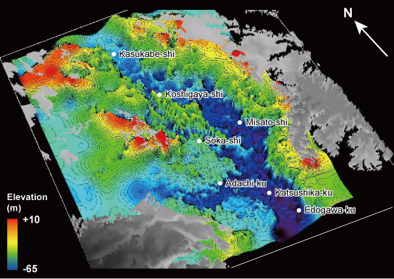
Basal topography of the Alluvium under the northern area of the Tokyo Lowland and Nakagawa Lowland.
This basal topography was formed due to a channel incision related to the sea-level lowering from the last interglacial to the Last Glacial Maximum (LGM). During the LGM, the Nakagawa from north to south and the Arakawa from west to east gathered as the Paleo-Tokyo River in the northern area of the Tokyo Lowland. The Paleo-Tokyo River flowed to the Tokyo Bay mouth. This basal topography is filled with the Alluvium deposited in relation to the last deglacial sea-level rise. The Alluvium now forms soft unconsolidated sediments under the northern area of the Tokyo Lowland and Nakagawa Lowland. This figure was illustrated based on the depth distribution of the Alluvium basement of 7,021 borehole logs and interpolation of the depth distribution by the inverse distance weighting method. See Tanabe et al. (2008) in this issue for details.
(Figure and caption: Susumu Tanabe)
Table of Contents
| Title | Author | |
|---|---|---|
| Article | ||
| Basal topography of the Alluvium under the northern area of the Tokyo Lowland and Nakagawa Lowland, central Japan. | Susumu Tanabe, Toshimichi Nakanishi, Katsumi Kimura, Shoichi Hachinohe and Toshio Nakayama (497-508) | 59_11_01.pdf [2 MB] |
| Sequence stratigraphy and paleogeography of the Alluvium under the northern area of the Tokyo Lowland, central Japan. | Susumu Tanabe, Yoshiro Ishihara and Rei Nakashima (509-547) | 59_11_02.pdf [18 MB] |
Abstract
Basal topography of the Alluvium under the northern area of the Tokyo Lowland and Nakagawa Lowland, central Japan.
Susumu Tanabe, Toshimichi Nakanishi, Katsumi Kimura, Shoichi Hachinohe and Toshio Nakayama
In this study, we identified the basement of the latest Pleistocene to Holocene incised-valley fills (Alluvium) from 7,021 borehole logs in the northern area of the Tokyo Lowland and Nakagawa Lowland. We constructed the dataset, which consists of the latitude and longitude of the borehole site and depth of the Alluvium basement. The depth-distribution map of the Alluvium was illustrated based of this dataset and interpolation of the Alluvium depth distribution by the inverse distance weighting method. We assumed the top of the Basal Gravel of the Alluvium as the basement of the Alluvium where the Basal Gravel exists. This depth-distribution map illustrates a detailed topography of the Nakagawa, Moto-arakawa, Ayasegawa, Arakawa and Paleo-Tokyo River Valleys, buried terraces and buried wave-cut benches. The comparison between the thickness of the Alluvium and surface elevation in the northern area of the Tokyo Lowland and Nakagawa Lowland indicates that there are major relationships. The elevation is less than T.P. +2 m in the area where the Alluvium thickness is more than 40 m, and the elevation is more than T.P. +2 m in the area where the Alluvium thickness is less than 25 m.
Sequence stratigraphy and paleogeography of the Alluvium under the northern area of the Tokyo Lowland, central Japan.
Susumu Tanabe, Yoshiro Ishihara and Rei Nakashima
The Tokyo Lowland, surrounded by the Shimosa, Omiya and Musashino Uplands, is a coastal lowland mainly formed by the Tonegawa. Latest Pleistocene to Holocene incised-valley fills (the Alluvium) in the northern area of the Tokyo Lowland comprise complicated lithological distribution considerably affected by the basal topography and river shift of the Tonegawa. To clarify this complicated lithological distribution, we constructed a three-dimensional sequence stratigraphy and paleogeography of the northern area of the Tokyo Lowland based on sedimentary facies and radiocarbon dates of eight sediment cores and 2,308 borehole logs.
The Alluvium, which filled the incised valleys of the Nakagawa, Arakawa and Paleo-Tokyogawa, consists of gravelly braided river sediments, meandering river sediments of sand-mud alternation with rootlets, estuary sediments of sand and mud bed with shells, spit sediments of sand with shells and shelly delta sediments, in which the contents of sand and wood fragments increase upward, in ascending order. By applying sequence stratigraphic concepts, a transgressive surface dated >14,100 cal BP and maximum flooding surface dated 8,100-5,900 cal BP can be identified at the braided river-meandering river sediments boundary and estuary-delta sediments boundary, respectively. Spit sediments form a local sediment body in the eastern margin of the Tokyo Lowland's northern area.
The paleogeography of the northern area of the Tokyo lowland changed from a braided river to a meandering river, tidal flat and bay due to the sea-level rise since after the Last Glacial Maximum. Sand bar and delta sediments accumulated in the Arakawa Valley in response to the Tonegawa sediment discharge in the Arakawa Valley during 10,000-5,000 cal BP. On the other hand, a tidal river was distributed in the Nakagawa Valley because of the lack of sediment at that time. The Nakagawa Valley was filled with the Tonegawa sediments since the river shift from the Arakawa Valley to the Nakagawa Valley around 5,000 cal BP. Clastics eroded from Pleistocene terraces formed a spit in the bay mouth portion of the Paleo-Okutokyo Bay during 8,000-4,000 cal BP.
Geological Survey of Japan, AIST
- About GSJ
- Our Activities
- Purchase guide
-
Publications and Database
- information
-
Bulletin of the Geological Survey of Japan
- bull2026(Vol.77)
- bull2025(Vol.76)
- bull2024(Vol.75)
- bull2023(Vol.74)
- bull2022(Vol.73)
- bull2021(Vol.72)
- bull2020(Vol.71)
- bull2019(Vol.70)
- bull2018(Vol.69)
- bull2017(Vol.68)
- bull2016(Vol.67)
- bull2015(Vol.66)
- bull2014(Vol.65)
- bull2013(Vol.64)
- bull2012(Vol.63)
- bull2011(Vol.62)
- bull2010(Vol.61)
- bull2009(Vol.60)
- bull2008(Vol.59)
- bull2007(Vol.58)
- bull2006(Vol.57)
- bull2005(Vol.56)
- bull2004(Vol.55)
- bull2003(Vol.54)
- bull2002(Vol.53)
- bull2001(Vol.52)
- Bulletin of the Geological Survey of Japan(old)
- Annual Report on Active Fault and Paleoearthquake Researches
- Reports, Geological Survey of Japan
- CCOP-GSJ Groundwater Project Report
- CCOP Technical Bulletin
- Cruise Report
- Geological Hazards
- Learning and Education
- GSJ Database Collection
- Collection of links