Bulletin of the Geological Survey of Japan Top Page
Bulletin of the Geological Survey of Japan Vol.59 No.1/2 (2008)
Cover photograph | Table of Contents | Abstract
Special Issue: The basic study on the assessment of influence by heat and hydrothermal water for geological disposal of nuclear waste (Part 2)
Cover photograph
The project is an examination of evaluation methods for the effects of heat and hydrothermal water on the surroundings of the geological repository. Tohoku was selected as the model district for this case study. The distribution maps of topography, geology, seismic hypocenters, Curie-point depth, subsurface isotherms, hot springs, heat flow, seismic velocity and so on were collected, and summarized as input into the database for 2D and 3D visualization. The characterization on wide areas including high-temperature anomaly regions of the Tohoku district were examined based on the interpretation of geological and geophysical data sets. The conceptual model for a representative cross section was drawn as integration of whole features in the Tohoku district.
(Shiro Tamanyu)
Table of Contents
| Title | Author | |
|---|---|---|
| [Review] Summary of the basic study on the assessment of influence by heat and hydrothermal water for geological disposal of nuclear waste (Part 2). | Shiro Tamanyu, Keiichi Sakaguchi and Shinsuke Nakao (1-6) | 59_01_01.pdf [376 KB] |
| 1. An examination of earth scientific characteristics of high-temperature anomaly areas. | ||
| [Report] Integration of geological and geophysical data for extraction of subsurface thermal and hydrothermal anomaly areas -Examples in Tohoku and Chugoku/Shikoku districts, Japan. | Shiro Tamanyu, Keiichi Sakaguchi, Tatsuya Sato and Masashi Kato (7-26) | 59_01_02.pdf [1,577 KB] |
| [Article] K-Ar ages and chemistry of the Miocene intrusive rocks in the Hongu hot spring area, Wakayama Prefecture, Japan. | Hirofumi Muraoka (27-43) | 59_01_03.pdf [1,948 KB] |
| [Report] Classification of wide areas including high-temperature regions from the viewpoint of subsurface temperature distribution -Examples of Tohoku and Chugoku/Shikoku districts. | Shiro Tamanyu (45-52) | 59_01_04.pdf [634 KB] |
| 2. An examination of genetic origin of high-temperature anomaly areas. | ||
| [Article] >Numerical simulations of regional-scale groundwater flow considering influence of heat and hydrothermal water. | Shinsuke Nakao, Tsuneo Kikuchi and Shiro Tamanyu (53-64) | 59_01_05.pdf [1,289 KB] |
| 3. An examination of survey, analysis and evaluation methods. | ||
| [Report] Study on the analytical methods for extraction of heat anomalies and their characterization based on distribution of heat discharge from hot springs. | Keiichi Sakaguchi (65-69) | 59_01_06.pdf [553 KB] |
| [Report] Various alteration environments studied through making a rock-alteration database for geothermal wells, and modeling of six case-study areas in Japan. | Hiroshi Shigeno (71-107) | 59_01_07.pdf [4,829 KB] |
| [Review] The assessment of influence by heat and hydrothermal water using electron spin resonance. | Keiko Mizugaki (109-116) | 59_01_08.pdf [401 KB] |
| [Report] Basic numerical analysis of genesis of groundwater chemistry. | Munetake Sasaki (117-122) | 59_01_09.pdf [510 KB] |
| 4. Integrated survey, analysis and evaluation methods for heat and hydrothermal assessment of geological repository. | ||
| [Review] Proposal of surveys, analyses and evaluation methods for the effects of heat and hydrothermal water on surroundings of geological repository at the stage of Preliminary Investigation. | Shiro Tamanyu and Keiichi Sakaguchi (123-134) | 59_01_10.pdf [788 KB] |
Abstract
Summary of the basic study on the assessment of influence by heat and hydrothermal water for geological disposal of nuclear waste (Part 2).
Shiro Tamanyu, Keiichi Sakaguchi, Shinsuke Nakao
The report is intended to open the result of three-year contract research to the public as the final report. This project was funded by the Nuclear Waste Management Organization of Japan (NUMO). The preliminary result and background of the project was reported as the special issue of Bull. Geol. Surv. Japan in 2004. Therefore, this report was named as part 2. The purpose of the study is to comprehend earth scientific characteristics and genetic origins of high-temperature anomaly areas, and to examine the evaluation methods for the influence of heat and hydrothermal water on surroundings by geological repository at the stages of extraction of Preliminary Investigation Areas (PIAs) and of its following site-specific surveys. The characterization on wide areas including high-temperature anomaly regions of the Tohoku and Chugoku/Shikoku districts are examined, and the conceptual models for representative cross sections of both districts are drawn. The outline of investigation results are described for every theme as follows.
- An examination of earth scientific characteristics of high-temperature anomaly areas
The reference surveys, data acquisition and evaluation analysis are carried out as follows.
1) Information gathering on earth scientific characteristics and 2D-3D visualization of data
Geological, geophysical and temperature logging data sets of the Tohoku and Chugoku/Shikoku districts were collected. These data sets were summarized by the data base software for 2D and 3D visualization in order to understand the properties and conditions of underground heat source, thermal structure, fracture systems, and hydrothermal systems.
2) Characterization of the high-temperature hot springs of the Kii peninsula
The origin of the high-temperature hot springs of the Kii peninsula were examined on the basis of regional tectonics and local characteristics.
3) An examination of the characterization on regions including high-temperature areas
The classification of the high-temperature anomaly areas of the Tohoku and Chugoku/Shikoku districts was examined with reference to the results of data analysis [1)] and the fluid flow simulation [2.]. - An examination of genetic origin of high-temperature anomaly areas
A precise model was developed using geologic and other data along the E-W cross section in the middle Tohoku district, and a series of sensitivity analyses by multi-components and multi-phases simulator were carried out. - An examination of survey, analysis and evaluation methods
In order to confirm the optimum survey, analysis and evaluation methods for heat and hydrothermal influences, the following items were investigated.
1) An examination of analytical methods for extraction of heat anomalies and their characterization based on discharged heat from hot springs
Preliminary calculation of discharged heat from hot springs was carried out at Southwestern Honshu and Aomori prefecture. Old and new datasets of hot spring lists were available for this calculation, and the difference of calculated results was compared each other.
2) An examination of various alteration environments through making a rock-alteration database for geothermal wells, and modeling of six case study areas in Japan
Various alteration environments and their controlling factors have been studied, using explorationwell alteration data obtained by NEDOfs Geothermal Development Promotion Survey.
3) An analytical method of long-term change of geothermal system by radiometric dating method
Reference survey on ESR dating of the minerals with low mineralization temperature was made. Examination and experiments on temperature-time evaluation in the ESR dating method were carried out and problems were figured out.
4) An evaluation method for heat and hydrothermal activity effects based on fluids geochemistry
Characteristics and diversity of fluids in granitic and sedimentary terrains were simulated under the condition of various fluids sources and various degrees of water-rock interaction using the geochemical simulator. - Proposal of evaluation methods for the effects of heat and hydrothermal water on surroundings by geological repository during Preliminary Investigation
Based on the results of this three-year study, evaluation methods for the influence of heat and hydrothermal water on surroundings by geological repository during planning of Preliminary Investigation and its following site-specific surveys were proposed.
The reports of analytical methods by electromagnetic survey and hypocenter distribution are omitted in this special issue for personal reasons.
Integration of geological and geophysical data for extraction of subsurface thermal and hydrothermal anomaly areas -Examples in Tohoku and Chugoku/Shikoku districts, Japan.
Shiro Tamanyu, Keiichi Sakaguchi, Tatsuya Sato and Masashi Kato
In order to clarify the situation and origin of subsurface high temperature anomaly in nonvolcanic area, the middle northern part and northern part of Tohoku district, and Chugoku/Shikoku district are selected as the model fields for this case study. The distribution maps of topography, geology, subsurface isotherms, Curie-point isothermal depth, seismic hypocenter, electric resistivity, and P-wave velocity were collected and summarized as input data to the database for 2-D and 3-D visualization. After digitizing, mutual correlations among various data are investigated. Major results are as follows. In deeper part, subsurface temperatures are generally higher at back-arc region than at fore-arc region, and also those of mountain regions are relatively higher than of plain regions for both back-arc and fore-arc regions respectively. These deep thermal features are correlated with thermal gradient, gravity basement depths, Curie-point isotherm depths and P-wave velocity. In shallow part, subsurface temperatures are relatively high in Quaternary volcanic regions by the high-level heat sources, and also somewhat high in plain regions by cap rock playing the shield for underlying hydrothermal convection. These shallow thermal features are correlated with thermal gradient, hot spring, electric resistivity and P-wave velocity.
K-Ar ages and chemistry of the Miocene intrusive rocks in the Hongu hot spring area, Wakayama Prefecture, Japan.
Hirofumi Muraoka
To elucidate the genesis of the Hongu hot springs in Wakayama Prefecture, K-Ar dating and chemical analyses of quartz porphyry intrusive bodies that control the discharge of thermal water have been carried out. The heat source of the Hongu hot springs is ascribed to the high heat flow of the spreading axis of the Shikoku Basin slab underplating the Kii Peninsula. K-Ar ages 14.6 Ma and 14.4 Ma are obtained on the Takayama stock and Kawayu sheet, respectively. Based on the Q-Or-Ab residua system, the magma of the Takayama stock and Kawayu sheet is probably generated at a depth of about 20 km. Major and trace element compositions of the Takayama stock and Kawayu sheet are typical of the S-type granitoid and have resemblance to those of sandstone of the Otonashigawa Group, suggesting that sandstone has selectively been fused in the anatexis of the flysch sediments when the temperature and degree of partial fusion are restricted. The hydrothermal reservoir of the Hongu hot springs is ascribed to the cooling joints penetrative in quartz porphyry sheets and dikes that have high permeability in contrast with the surrounding impermeable flysch sediments. When a permeable body is continued from the depth of 20 km to the ground surface in the high heat flow area, hydrothermal convection will automatically occur. This could be the genesis of the Hongu hot springs.
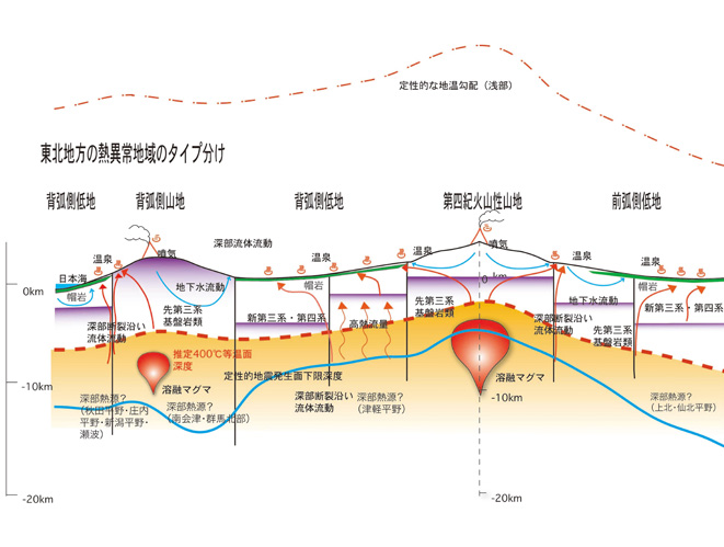
Classification of wide areas including high-temperature regions from the viewpoint of subsurface temperature distribution -Examples of Tohoku and Chugoku/Shikoku districts
Shiro Tamanyu
The characterization on wide areas including high-temperature anomaly regions of the Tohoku and Chugoku/Shikoku districts are examined based on the geological and geophysical data sets. From the viewpoint of topographic and geologic features, following 5 type areas are identified in each district: fore arc plain, fore arc mountain, Quaternary volcanic terrain, back arc plain and back arc mountain. The conceptual models for representative cross sections of both districts are drawn. The thermal and hydrothermal features of each type area are described in detail based on the overlaid various data sets.
Numerical simulations of regional-scale groundwater flow considering influence of heat and hydrothermal water.
Shinsuke Nakao, Tsuneo Kikuchi and Shiro Tamanyu
Numerical simulations of regional-scale groundwater flow and heat transport using a 2-D model are conducted along the E-W Tohoku region which covers 120 km length and 8.7 km depth. In the numerical simulations, geological and topographical data are incorporated to construct a precise numerical model. A multi-component, multi-phase geothermal reservoir simulator is used for the numerical simulations. As results of sensitivity analysis, it is necessary to assign inhomogeneous heat sources (heat flows) at the bottom of the model to qualitatively reproduce high-temperature anomalies right beneath the mountain areas. It is also revealed that deep-seated hot water around the temperature of 50 oC can be found even right beneath the plains due to heat and groundwater convection and advection driven by topographical effects, although volcanic high-temperature heat sources are not existed under the plains.
Study on the analytical methods for extraction of heat anomalies and their characterization based on distribution of heat discharge from hot springs.
Keiichi Sakaguchi
Hot spring heat discharge at the areas of Aomori, Chugoku and Shikoku districts is investigated based on the data including the information of hot spring production depths. The relationships among the temperatures, amounts of hot water/heat discharge and their depths are different at the areas. The amounts of water/heat discharge from hot springs are generally related to formation permeability on the scale of wide area. To have a better understanding of subsurface condition, it is preferable for full specifications of hot springs to be complete regarding temperature, production depths, amount of water discharge, condition and behavior.
Various alteration environments studied through making a rock-alteration database for geothermal wells, and modeling of six case-study areas in Japan.
Hiroshi Shigeno
Various alteration environments and their controlling factors have been studied, using exploration- well alteration data obtained by NEDO's Geothermal Development Promotion Survey, through (1) electronic database construction for the purpose of wide advanced utilization of rock alteration data, and (2) data processing and conceptual modeling of six case study areas.
(1) The alteration data (the depth-mineral distributions) for each of the 271 wells in the reports of 14 and 21 areas in Kyushu and Honshu, respectively, have been transferred to tables using spreadsheet software (Microsoft Excel) for the database construction. However, it will take years to make the database open to public due to the difficulty of data integration, because, in the Geothermal Development Promotion Survey, the methods and configurations of obtaining and presenting the alteration mineral data have been rather varied area to area (also the data from seventeen areas in Hokkaido and some other areas have not been edited yet). In this article, the differences of the alterations among the areas have been discussed preliminarily based on summaries in tables for wells, and in regional maps for the areas using sixteen mineral species strongly indicative for characteristics of the alteration environments.
(2) For conceptual modeling of the alteration environments, two high-temperature areas, Asosan- Seibu (Kumamoto Pref.) and Hachijjojima (Tokyo Pref.) areas, and four low-temperature areas, Hishikari (Kagoshima Pref.), Hongu (Wakayama Pref.), Otaki (Nagano Pref.) and Mogami-Akakura (Yamagata Pref.) areas have been studied. For each area, detailed typical columnar figures, a parallel columnar figure, and columnar presentation on a map of the well data (temperature, geology, and alteration) have been produced using well-logging data processing programs in Digital Geoscience Map, GT-3 (Geological Survey of Japan, 2007). The results of the conceptual modeling show that various alteration zones have been developed underground even at the low-temperature areas, because of various causes including characteristics and distributions of heat sources and hydrothermal systems, inhomogeneous fluid flow structures due to distributions of topography, fracture systems and lithology, and chemical differentiation due to liquid-gas separation, and others. Rock alteration survey could be one of the powerful methods for understanding subsurface environments of nonvolcanic areas.
The above study has been conducted as a part of the Study on Assessment Methods for Thermal and Hydrothermal Effects (FY 2003-2005) concerning geologic storage of nuclear wastes (HLW). In surveying potential storage areas, rock alteration survey is important for the purpose of understanding and assessing the past-present-future thermal and hydrothermal environments, and the above results could be effectively utilized as one of the basic information. Also, information on rock alterations is very important for various subjects in geoscience and engineering fields, i.e. resources development, environmental protection, hazard mitigation, underground space utilization, and others. Hence, future construction of electronic database integrating not only hydrothermal alterations, but also thermal, diagenetic, weathering, and other alterations, as one of the fundamental earth-science information, and its easy, wide and advanced applications will be expected.
The assessment of influence by heat and hydrothermal water using electron spin resonance.
Keiko Mizugaki
In order to evaluate effects of geothermal anomalies at high-level radioactive wastes disposal sites, previous studies applying electron spin resonance (ESR) mesurement to various samples and objectives have been reviewed, such as low-temperature hydrothermal water, detailed analysis of paleotemperature, and spatial distribution of thermal effects. ESR measures unpaired electrons trapped at defects in mineral crystals, therefore crystallization can be regarded as initial condition as well as cooling. Some reports of ESR measurement on sinters and stalactite, which had been precipitated from hot springs and cold groundwater respectively, have been found. A few kinds of ESR signals show enhancement under heating condition to natural hydrothermal temperature, and this property had used to detailed analysis of heating temperature of archeological implements. In case that fracture zones provide paths to hydrothermal fluid, calculated ESR ages of altered country rocks are expected to be older depending on distances from fractures, that can be applied to estimate extent and intensity of thermal effects. However, no report has been found that examines long-time heating nor cooling process systematically, and such experiments are needed for this purpose.
Basic numerical analysis of genesis of groundwater chemistry.
Munetake Sasaki
Basic numerical analysis on interactions between groundwaters and rocks concerned with the geological repository of nuclear waste in Japan were conducted in order to understand the chemical evolution processes of groundwaters. The evolution processes of groundwaters in granite and muddy sediment were examined, and the influence of heat to groundwaters was discussed. And cautions in application of numerical simulation to water-rock interaction modeling were summarized.
Proposal of surveys, analyses and evaluation methods for the effects of heat and hydrothermal water on surroundings of geological repository at the stage of Preliminary Investigation
Shiro Tamanyu and Keiichi Sakaguchi
The effects of heat and hydrothermal water on surroundings of geological repository were investigated in the past the three-year study. Considering this result, the surveys, analyses and evaluation methods for the planning of Preliminary Investigation and its following site-specific surveys are investigated. The applicable surveys/analyses/evaluation methods corresponding to the survey targets, stages and classified type areas are summarized. Survey targets are roughly subdivided into shallow and deep parts. Evaluation items for shallow part are as follows: regional surface imagery, regional geological structure, drilling and logging data, subsurface temperature distribution, fluid flow, permeability distribution, water-rock interaction. Evaluation items for deep part are as follows: estimation of deep temperature, concealed heat source/deep heat source and deep fractures. Survey stages are divided into surface survey, subsurface survey with boring survey and future estimation. Classified type areas are as follows: forearc plain, forearc mountain, Quaternary volcanic terrain, backarc plain, backarc mountain. An overall picture of surveys, analyses and evaluation methods is presented as table.
Geological Survey of Japan, AIST
- About GSJ
- Our Activities
- Purchase guide
-
Publications and Database
- information
-
Bulletin of the Geological Survey of Japan
- bull2026(Vol.77)
- bull2025(Vol.76)
- bull2024(Vol.75)
- bull2023(Vol.74)
- bull2022(Vol.73)
- bull2021(Vol.72)
- bull2020(Vol.71)
- bull2019(Vol.70)
- bull2018(Vol.69)
- bull2017(Vol.68)
- bull2016(Vol.67)
- bull2015(Vol.66)
- bull2014(Vol.65)
- bull2013(Vol.64)
- bull2012(Vol.63)
- bull2011(Vol.62)
- bull2010(Vol.61)
- bull2009(Vol.60)
- bull2008(Vol.59)
- bull2007(Vol.58)
- bull2006(Vol.57)
- bull2005(Vol.56)
- bull2004(Vol.55)
- bull2003(Vol.54)
- bull2002(Vol.53)
- bull2001(Vol.52)
- Bulletin of the Geological Survey of Japan(old)
- Annual Report on Active Fault and Paleoearthquake Researches
- Reports, Geological Survey of Japan
- CCOP-GSJ Groundwater Project Report
- CCOP Technical Bulletin
- Cruise Report
- Geological Hazards
- Learning and Education
- GSJ Database Collection
- Collection of links