Bulletin of the Geological Survey of Japan Top Page
Bulletin of the Geological Survey of Japan Vol.58 No.9/10 (2007)
Cover photograph | Table of Contents | Abstract
Cover photograph
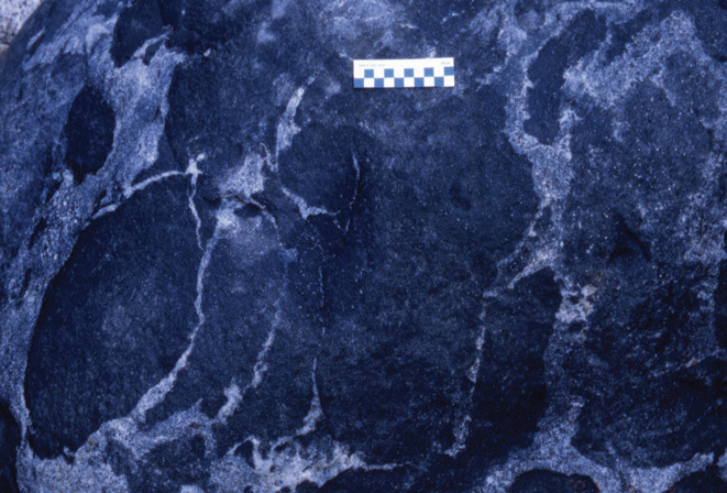
Mingling dike of the Ryoke metamorphic belt.
Mingling dikes of mafic and felsic magmas are seen in the Ryoke metamorphic zone of central Honshu. They occur mostly in metamorphic rocks of the sillimanite zone, and the latest one is seen as diabasic dike in granitic rocks. Thus, these dikes were active in a long period of the Cretaceous time and brought up heat from the upper mantle. The photograph taken at southwest of Taguchi, Aichi Prefecture.
(Shunso Ishihara)
Table of Contents
| Title | Author | |
|---|---|---|
| Article | ||
| Data base of the volcanic ash fall distribution map of Japan. | Shigeru Suto, Takayuki Inomata, Hisashi Sasaki and Sakae Mukoyama (261-321) | 58_09_01.pdf [3,199 KB] |
| Appendix Table1(extended) | 58_09_01_01.xls [288 KB] | |
Appendix Fig.1
|
58_09_01_01.pdf [8,757 KB] | |
|
58_09_01_02.pdf [9,000 KB] | |
|
58_09_01_03.pdf [8,892 KB] | |
|
58_09_01_04.pdf [8,322 KB] | |
|
58_09_01_05.pdf [9,675 KB] | |
|
58_09_01_06.pdf [8,722 KB] | |
|
58_09_01_07.pdf [9,545 KB] | |
|
58_09_01_08.pdf [8,818 KB] | |
|
58_09_01_09.pdf [7,783 KB] | |
|
58_09_01_10.pdf [9,897 KB] | |
|
58_09_01_11.pdf [6,759 KB] | |
|
58_09_01_12.pdf [7,126 KB] | |
|
58_09_01_13.pdf [8,426 KB] | |
|
58_09_01_14.pdf [7,743 KB] | |
|
58_09_01_15.pdf [8,518 KB] | |
| Chemical compositions of the late Cretaceous Ryoke granitoids of the Chubu District, central Japan - Revisited. | Shunso Ishihara and Bruce W. Chappell (323-350) | 58_09_02.pdf [2,338 KB] |
Abstract
Data base of the volcanic ash fall distribution map of Japan.
Shigeru Suto, Takayuki Inomata, Hisashi Sasaki and Sakae Mukoyama
The whole total distribution map of the volcanic ash fall deposit in Japan was summarized with the data base under the program of the “Research on volcanic ash fall hazard assessment and risk management for industrial location” and the “Impact analysis on the volcanic ash-fall in the metropolitan area”. The heavy ash fall will cause the serious disaster of course, but well developed area also suffered heavy economical damage by even a thin deposit of volcanic ash. Around five hundred distribution maps of the volcanic ash fall deposits in Japan in these three hundred thousand years were collected. The first work is to redraw the isopach map completely for each unit, because major of the isopach map in the literature were not perfect in shape. The redrawing for each contour line was carried out mathematically to extend each semicircular curve to make a close circle automatically. The redrawn isopachs were reserved as a digital data and the thickness of the deposit between each contour line for around each one kilometer mesh, which is authorized by the third Digital National Land Information system in Japan, were calculated by logarithmical proportional allotment. The worked area was from 24 to 46 degree in the north latitude and from 123 to 149 degree in the east longitude. The name of the volcano, unit name and its alphabetical abbreviation, age of the eruption, and the references, of each ash fall unit were summarized as a data base for each mesh. So it is possible to show the thickness of each ash fall unit for each one kilometer mesh. For example Haneda airport and Narita airport were estimated to be suffered the 8.7 and 3.2 centimeters ash fall from Fuji volcano in 1707 respectively. And also it is easy to find the ash fall disaster history for anywhere and any municipality, cities and towns, which number is around two thousand, in Japan. For example the municipal office building of the Tokyo Metropolitan in Shinjuku has been suffered three, five, and seventeen times air fall ash in these one thousand, ten thousand, and a hundred thousand years, respectively, and the thickness of the deposit for each periods are also able to be shown using the data base.
Chemical compositions of the late Cretaceous Ryoke granitoids of the Chubu District, central Japan - Revisited.
Shunso Ishihara and Bruce W. Chappell
Late Cretaceous plutonic rocks of 6 gabbroids, and 75 granitoids, all belonging to ilmenite series, were re-examined by polarized XRF method. The gabbroids are relatively abundant in the south of the studied region, implying more in-put of heat and mafic magmas from the upper mantle to the lower crust. The MgO/Fe2O3 ratio of the gabbroids reveal regional variation being MgO-rich to the south, which would reflect generation depth of the mafic magmas. The granitoids are classified into I type and S type. The I-type granitoids occur most widely and divided into five zones. Their average silica contents vary from the Median Tectonic Line to the north as follows: Shinshiro-Shitara zone (60.1 % SiO2), Asuke zone (64.2 %), Toyota-Akechi zone (70.0 %), Sanagesan-Obara zone (73.9 %) and Seto zone (75.2 %). This regional variation was considered to reflect chemical heterogeneity of the infracrustal source rocks, rather than the magmatic differentiation.
Granitoids of the Okazaki-Busetsu zone, represented by garnet-bearing muscovite-biotite granites, occur in the highest metamorphic grade zone, and is felsic (average SiO2 70.2 %), peraluminous (A/CNK over 1.1), and thus be called S type. Because of the highest heat flow rate in the Okazaki- Busetsu zone, even supracrustal rocks were converted to magmas and formed the S-type granites. Both I and S type granitoids are often heterogeneous in the foliated parts, as compared with massive granitoids of non-metamorphic terrains. The heterogeneity can be considered due to different original compositions of the source materials and/or formed by differential regional stress during the flow movement of the solidifying magmas. Lack of hydrothermal mineralization in the south where metamorphic roof-pendent still remain, can be explained by a deep emplacement level (~15 km) and small degree of fractionation of these granitic magmas.
Geological Survey of Japan, AIST
- About GSJ
- Our Activities
- Purchase guide
-
Publications and Database
- information
-
Bulletin of the Geological Survey of Japan
- bull2026(Vol.77)
- bull2025(Vol.76)
- bull2024(Vol.75)
- bull2023(Vol.74)
- bull2022(Vol.73)
- bull2021(Vol.72)
- bull2020(Vol.71)
- bull2019(Vol.70)
- bull2018(Vol.69)
- bull2017(Vol.68)
- bull2016(Vol.67)
- bull2015(Vol.66)
- bull2014(Vol.65)
- bull2013(Vol.64)
- bull2012(Vol.63)
- bull2011(Vol.62)
- bull2010(Vol.61)
- bull2009(Vol.60)
- bull2008(Vol.59)
- bull2007(Vol.58)
- bull2006(Vol.57)
- bull2005(Vol.56)
- bull2004(Vol.55)
- bull2003(Vol.54)
- bull2002(Vol.53)
- bull2001(Vol.52)
- Bulletin of the Geological Survey of Japan(old)
- Annual Report on Active Fault and Paleoearthquake Researches
- Reports, Geological Survey of Japan
- CCOP-GSJ Groundwater Project Report
- CCOP Technical Bulletin
- Cruise Report
- Geological Hazards
- Learning and Education
- GSJ Database Collection
- Collection of links