Bulletin of the Geological Survey of Japan Top Page
Bulletin of the Geological Survey of Japan Vol.53 No.2/3 (2002)
Cover photograph | Table of Contents | Abstract
Cover photograph
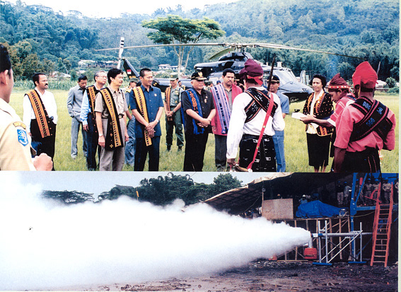
Highlights of Indonesia-Japan Flores Island geothermal project
Upper: one of the ultimate goals of geothermal explorations for geothermal power generation is to acquire natural steam by drilling to geothermal reservoirs at depths where the effectiveness of geothermal explorations is strictly tested by the drilling result. The "Research Cooperation Project on the Exploration of Small-scale Geothermal Resources in the Eastern Part of Indonesia" was also tested by the drilling. The upper photograph shows distinguished guests including members of Indonesia Parliament getting off a helicopter that came from Kupan, Timor Island to Mataloko, Flores Island earlyin the morning of January 20, 2001. Residents were giving them a warm welcome in a traditional way. Their purpose of visit was to observe a flow test of NEDO well MT-2. Since the drilling equipments were restricted in a remote island area, this well was only drilled to a depth of 162.35m extremely shallow and it was a moment that all the members of this project were anxious.
Lower: However, the flow test was quite successful as shown in the lower photograph. About 15 tons per hour of dry steam were stably produced at a valve-full-open state. The amounts are not small respective to the depth of the well. The shallowness of the reservoir seems a merit for economical development in turn. Dry steam also brings an advantage for seems a merit for the small-scale geothermal power development because we can save the drilling of reinjection wells.
(Hirofumi MURAOKA)
Table of Contents
| Title | Author | |
|---|---|---|
| Frontispieces | ||
| Graphical overview of the Indonesia-Japan ESSEI Project in Flores Island. | Hirofumi MURAOKA, Toshihiro UCHIDA, Minoru URAI, Masao KOMAZAWA and Masaaki TAKAHASHI (I-VI) | 53_02_g1.pdf [377 KB] |
| Preface | Masakatsu SASADA (61-62) | 53_02_01.pdf [52 KB] |
| PART I. BACKGRAUND OF PROJECT | ||
| Overview of the "Research Cooperation Project on the Exploration of Small-scale Geothermal Resources in the Eastern Part of Indonesia" by the Geological Survey of Japan. | Hirofumi MURAOKA and Toshihiro UCHIDA (63-78) | 53_02_02.pdf [623 KB] |
| Geothermal development for supporting the Rural Electrification Program in Indonesia. | Sjafra DWIPA (79-86) | 53_02_03.pdf [354 KB] |
| Geothermal prospects of Flores Island in Indonesia viewd from Their volcanism and hot water geothermal geochemistry. | Asnawir NASUTION, Hirofumi MURAOKA, Mawardi RANI, Isao TAKASHIMA, Masaaki TAKAHASHI, Hideo AKASAKO, Koji MATSUDA and Muhammad BADRUDIN (87-98) | 53_02_04.pdf [579 KB] |
| PART II. REMOTE SENSING AND GEOLOGY | ||
| Satellite remote sensing date and their interpretation for geothermal applications: A case study on the Ngada District, central Flores, Indonesia. | Minoru URAI, Hirofumi MURAOKA and Asnawie NASUTION (99-109) | 53_02_05.pdf [491 KB] |
| Tectonic, volcanic and stratigraphic geology of the Bajawa geothermal field, central Flores, Indonesia. | Hirofumi MURAOKA, Asnawir NASUTION, Minoru URAI, Masaaki TAKAHASHI, Isao TAKASHIMA, Janes SIMANJUNTAK, Herry SUNDHORO, Dany ASWIN, Fredy NANLOHY, Kastiman SITORUS, Hiroshi TAKAHASHI and Takehiro KOSEKI (109-138) | 53_02_06.pdf [7,917 KB] |
| Thermoluminescence dating of volcanic and altered rocks in the Bajawa geothermal area, central Flores island, Indonesia. | Isao TKASHIMA, Asnawir NASUTION and Hirofumi MURAOKA (139-146) | 53_02_07.pdf [291 KB] |
| Geochemistry of volcanic rocks in the Bajawa geothermal field, Central Flores, Indonesia. | Hirofumi MURAOKA, Asnawir NASUTION, Minoru URAI, Masaaki TAKAHASHI And Isao TAKASHIMA (147-160) | 53_02_08.pdf [705 KB] |
| Geology, geochemistry and geochronology of the Bajawa area, central Flores, Indonesia: Geologic structure and evolution of the Bajawa depression. | Masami OTAKE, Hiroshi TAKAHASHI, Takehiro KOSEKI and Hiroo YOSHIYAMA (161-174) | 53_02_09.pdf [615 KB] |
| 2001 fissure-forming eruption of Inie Lika volcano, central Flores, Indonesia. | Hirofumi MURAOKA, Kasumi YASUKAWA, Minoru URAI, Masaaki TAKAHASHI, Asnawor NASUTION and Isao TAKASHIMA (175-182) | 53_02_10.pdf [355 KB] |
| PART III. GEOCHEMISTRY | ||
| Geochemical characteristics of hot spring water in Bajawa area, central Flores, Indonesia. | Masaaki TAKAHASHI, Minoru URAI, Kasumi YASUKAWA, Hirofumi MURAOKA, Koji MATSUDA, Hideo AKASAKO, Takehiro KOSEKI, Koichi HISATANI, Dedi KUSNADI, Bangbang SULAEMAN and Asnawir NASUTION (183-200) | 53_02_11.pdf [882 KB] |
| Hydrogen and oxgen isotopic compositions of subsurface water at Bajawa area, central Flores, Indonesia. | Masaaki TAKAHASHI, Minoru URAI, Kasumi YASUKAWA, Hirofumi MURAOKA, Koji MATSUDA, Hideo AKASAKO, Takehiro KOSEKI, Koichi HISATANI, Dedi KUSNADI, Bangbang SULAEMAN Terry SRIWANA and Asnawir NASUTION (201-210) | 53_02_12.pdf [442 KB] |
| The utilization of geothermal energy for the direct use in Mengeruda, Flores Island, Indonesia. | Herry SUNDHORO, Sjafra DWIPA, Asnawor NASUTION, Hiroshi TAKAHASHI, Janes SIMANJUNTAK, Arif MUNANDAR and Takehiro KOSEKI (211-216) | 53_02_13.pdf [261 KB] |
| Geochemistry of geothermal manifestations around Inielika volcano, Central Flores, Indonesia. | Dedi KUSNADI (217-230) | 53_02_14.pdf [590 KB] |
| PART IV. GEOPHYSICS | ||
| Gravity anomalies of the central Flores Island, Indonesia. | Masao KOMAZAWA, Kazuto MATSUKUBO, Zulkarnain NASUTION and Herry SUNDHORO (231-238) | 53_02_15.pdf [494 KB] |
| The comprehensive result of geological, geophysical and geochemical Surveys for geothermal resources in the Gou area, Flores Island, Indonesia. | Herry SUNDHORO, Sjafra DWIPA, Asnawir NASUTION, Hiroshi TAKAHASHI, Janes SIMANJUNTAK, Arif MUNANDAR and Takehiro KOSEKI (239-246) | 53_02_16.pdf [448 KB] |
| Head-on measurement to locate the Wai Luja Fault in the Mataloko Geothermal field, Flores Island, East Nusa Tenggara, Indonesia. | Arif MUNANDAR, Achmad ANDAN and Janes SIMANJUNTAK (247-252) | 53_02_17.pdf [236 KB] |
| Interpretation of DC resistivity date in the Bajawa geothermal field, central Flores, Indonesia. | Toshihiro UCHIDA, Achmad ANDAN and AHARI (253-264) | 53_02_18.pdf [485 KB] |
| 2-D and 3-D interpretation of magnetotelluric date in the Bajawa geothermal Flores, Indonesia. | Achmad ANDAN (265-284) | 53_02_19.pdf [872 KB] |
| Self-potential mapping of the Mataloko and Nage geothermal fields, Central Flores, Indonesia for applications on reservoir modeling. | Kasumi YASUKAWA, Achmad ANDAN, Dendi S. KUSUMA, Toshihiro UCHIDA and Tsuneo KIKUCHI (285-294) | 53_02_20.pdf [430 KB] |
| PART V. DRILLING AND COMPLETION | ||
| Drilling activity and subsurface geology of the MLT-1 shallow well In the Mataloko geothermal area. | Sri WIDODO, Fredy NANLOHY and Kastiman SITORUS (295-300) | 53_02_21.pdf [312 KB] |
| Grouting program in the Mataloko geothermal field. | Janes SIMANJUNTAK and Muhammad YUSUP (301-306) | 53_02_22.pdf [219 KB] |
| Exploratory well drilling and discharge test of wells MT-1 and MT-2 In the Mataloko geothermal field, Flores, Indonesia. | Yoshikazu SUEYOSHI, Koji MATSUDA, Tadahiko SHIMOIE, Takehiro KOSEKI, Hiroshi TAKASHI, Masao FUTAGOISHI, Kastiman SITORUS and Janes SIMANJUNTAK (307-322) | 53_02_23.pdf [683 KB] |
| PART VI. WELL LOGGING AND MONITORING | ||
| Characteristic of hydrothermal alteration minerals on MT-1 and MT-2 wells, Mataloko, central Flores, East Nusatenggara, Indonesia by using short-wave infrared reflectance spectroscopy. | Dany ASWIN and Fredy NANLOHY (323-328) | 53_02_24.pdf [272 KB] |
| Subsurface geology of the Mataloko geothermal field deduced from MTL-1, MT-1 and MT-2 wells, central Flores, East Nusa Tenggara, Indonesia. | Fredy NANLOHY, Kastiman SITORUS, KABANI,Sjafra DWIPA and Janes SIMANJUNTAK (329-336) | 53_02_25.pdf [388 KB] |
| Fluid inclusion study on the wells MT-1 and MT-2 in the Mataloko geothermal system, Inndonesia. | Takayuki SAWAKI and Hirofumi MURAOKA (337-342) | 53_02_26.pdf [219 KB] |
| Chemical and isotopic stydies of well discharge fluid of the Mataloko geothermal field, Flores, Indonesia. | Koji MATSUDA, Terry SRIWANA, Sofyan PRIMULYANA and Masao FUTAGOISHI (343-354) | 53_02_27.pdf [483 KB] |
| Reservoir response to a well test identified through a self-potential monitoring at the Mataloko geothermal field, central Flores, Indonesia. | Kasumi YASUKAWA, Enar KUSDINAR and Hirofumi MURAOKA (355-364) | 53_02_28.pdf [423 KB] |
| PART VII. INTERGRATION AND MODELING | ||
| Geology and hydrothermal alterations, and those correlations to Physical properties obtained from gravity and resistivity measurements in the Mataloko geothermal field. | Koichi TAGOMORI, Hiroki SAITO, Takehiro KOSEKI, Hiroshi TAKAHASHI, Sjafra DWIPA and Masao FUTAGOISHI (365-374) | 53_02_29.pdf [503 KB] |
| Conceptual models for geothermal systems in the Wolo Bobo, Nage and Mataloko fields, Bajawa area, central Flores, Indonesia. | Hideo AKASAKO, Koji MATSUDA, KOICHI TAGOMORI, Takehiro KOSEKI, Hiroshi TAKAHASHI and Sjafra DWIPA (375-388) | 53_02_30.pdf [740 KB] |
| Long term flow test of the MT-2 well, the Mataloko geothermal field, Ngada, Flores Island, Indonesia. | Kastiman SITOURUS, Fahmi SULISTYOHADI and Janes SIMANJUNTAK (389-398) | 53_02_31.pd [520 KB] |
| Development of Indonesia version Geothermal Expert Modeling System(iGEMS). | Takehiro KOSEKI, Hiroshi TAKAHASHI, Tadahiko SHIMOIKE and Kazuo HIYANE (399-408) | 53_02_32.pdf [485 KB] |
Abstract
Overview of the "Research Cooperation Project on the Exploration of Small-scale Geothermal Resources in the Eastern Part of Indonesia" by the Geological Survey of Japan.
Hirofumi MURAOKA and Toshihiro UCHIDA
A five-year Indonesia-Japan bilateral research cooperation program, named "Research Cooperation Project on the Exploration of Small-scale Geothermal Resources in the Eastern Part of Indonesia" (ESSEI Project), started in April 1997 and will end in March 2002. This paper gives an overview of the project by the Geological Survey of Japan as an introduction to this special volume. Background information of the project such as the objective, research cooperation regime, research schedule and shared takes are reviewed. Annual activity and outline results of the Geological Survey of Japan are described.
Geothermal development for supporting the Rural Electrification Program in Indonesia.
Sjafra DWIPA
Indonesia is blessed with abundant geothermal resources. However, only 787 Mwe of geothermal energy has been developed as of 2001. To further increase the capacity in Indonesia, we must overcome Obstacles like weak cost-competitiveness. Accordingly, anew regulation was issued that shows the government is willing to share the steam development risk and introducing fair competition and more efficient private sector participation. In supporting regional autonomy, the government made stable power supply and rural electrification as its top priorities for expansion of the infrastructure to promote the development of remote islands. The government electrified about 30,394 villages. We look forward to a fruitful cooperation on geothermal development and invite investors for capital investments to keeping momentum of growth.
Geothermal prospects of Flores Island in Indonesia viewd from Their volcanism and hot water geothermal geochemistry.
Asnawir NASUTION, Hirofumi MURAOKA, Mawardi RANI, Isao TAKASHIMA, Masaaki TAKAHASHI, Hideo AKASAKO, Koji MATSUDA and Muhammad BADRUDIN
Lavas of the Flores volcanic arc have a range of compositions from basalt to dacite but mostly andesite, containing pigeonite and olivine in island arc tholeiitic series and amphibole and biotite in calc-alkaline series. Chemically, the rocks show a wide variety of SiO2 (51-67 wt.%), Al2O3 (14-20 wt.%) and low TiO2 (<1 wt.%), together with relatively high Rb, Sr and Ba. These K group elements represent an increase of SiO2 with increasing depth of the Benioff zone. Strontium isotope ratios of tholeiitic to calc-alkaline lavas are 0.7042-0.7045, assumed with the depth of the subducted slab across the island. Flores geothermal prospects are situated in young volcanic terrains of andesite and basalt between 500 to 1000 m above sea level (a.s.l.) and associated with post volcanic fractures, faults and caldera structures. Hot water discharges represent a wide variety of chemical water types; sulfate, bicarbonate and chloride waters. Sulfate type is mostly associated with fumaroles and located on high volcanic terrains (700-1100 m a.s.l.), indicating the near-surface H2S oxidation (Ulumbu, Mataloko, Nage and Sokoria). Bicarbonate waters are located at the moderate slope of volcanics (400-700 m a.s.l.), shown by Langageda and Sokoria 2. Neutral chloride waters are located at the lower volcanic terrains approximately 5-600 m a.s.l., indicating an outflow from geothermal reservoirs with a temperature of 210 to 280 ºC, Geothermal wells that were drilled at the Ulumbu and Mataloko prospects to a depth of 700-800 m and 200 m, respectively have a subsurface temperature of 200 to 240 ºC, indicating that the high sulface concentration is associated with a vapordominated system. The same system probably occurs in the Sokoria field. While the geothermal prospects of high chloride water type are probably associated with hot-water or mixture system (Wai Sano, Wai Pesi, Jopu, Lesugolo and Oka).
Satellite remote sensing date and their interpretation for geothermal applications: A case study on the Ngada District, central Flores, Indonesia
Minoru URAI, Hirofumi MURAOKA and Asnawie NASUTION
A remote sensing survey was conducted in the Ngada District for geothermal exploration using JERS-1 SAR and OPS, and ASTER VNIR and TIR data. As a result, many small volcanic cones, which have diameters less than 5 km, are seen near the Bajawa in the SAR image. Some volcanic cones are aligned along the north-south direction. Since the SAR has allweather observation capability, it provides us with details of the volcanic features in the study area, where it is difficult to obtain clod-free images using optical sensors. Volcanic features are not as obvious in the OPS image compared with the SAR image because of the high sun elevation angle in tropical areas. A small high temperature anomaly is found at the Nage geothermal area using ASTER TIR, which is a new spaceborne sensor having a high spatial resolution. These result demonstrate the advantages and limitations of satellite remote sensing survey for geothermal applications.
Tectonic, volcanic and stratigraphic geology of the Bajawa geothermal field, central Flores, Indonesia.
Hirofumi MURAOKA, Asnawir NASUTION, Minoru URAI, Masaaki TAKAHASHI, Isao TAKASHIMA, Janes SIMANJUNTAK, Herry SUNDHORO, Dany ASWIN, Fredy NANLOHY, Kastiman SITORUS, Hiroshi TAKAHASHI and Takehiro KOSEKI
Regional geological investigation has been carried out since 1998 to evaluate geothermal resources in the Bajawa City and its surrounding areas of Flores Island as a part of the Reseach Cooperation Project on the Exploration of Small-scale Geothermal Resources in the Eastern Part of Indonesia (ESSEI Project). Since 4 Ma, volcanic activity occurred in two volcanic terrains: the central area and southern coast. Both of terrains from an element of the en echelon island structure characteristic from Flores to Alor Islands. An 800 m uplift occurred in the two terrains during the past 2.5 million years. In the central area, the Welas caldera formed at about 2.5 Ma. After its post-caldera volcanism, the volcanic activity has been almost extinct. On the southern coast, volcanic activity has been continued from 4 Ma to the present. The most conspicuous event was the appearance of the Bajawa lift zone that was related to the north-south left-lateral shear stress accommodated between the north moving Australian accretion block in the west and relatively fixed Sundaland block in the west. The Bajawa rift zone was initiated by the formation of a NNW-SSE elongated volcano probably during 0.8-0.2 Ma. It was followed by the collapse of the eastern flanks from its crest. The collapsed area produced the Bajawa Cinder Cone Complex that consists of more than 60 cinder cones aligned 20 km along the NNW-SSE trending rift zone. Although the majority of volcanic rocks in the study area is basaltic and tholeiitic, all the effusive rocks from the Bajawa Cinder Cones Complex are andesitic, calc-alkaline and very homogenous in composition. This suggests a connected dike swarm magma chamber beneath alignments of numerous cones of the Bajawa Cinder Cone Complex. Three steaming grounds and several high temperature hot springs in the study area are closely associated with the Bajawa rift zone magma system as a heat source.
Thermoluminescence dating of volcanic and altered rocks in the Bajawa geothermal area, central Flores island, Indonesia.
Isao TKASHIMA, Asnawir NASUTION and Hirofumi MURAOKA
Ages of volcanic and altered rocks distributed in the Bajawa geothermal area were determined by thermoluminescence (TL) dating. Ages for eight volcanic rocks samples are collected from formations younger than 0.15 Ma by K-Ar dating but their fixed ages have not been determined. Separated quartz and plagioclase are used for dating. Ages for eight volcanic rocks range from 32-160 ka. The youngest age of ka is obtained for Mt. Keli Inerie, a large active stratovolcano. Ages of 72-160 ka are first reported for small stratovolcanos that are characterized by clear craters at the summits and linearly arranged. Most acidic white colored alteration halos have been formed at low temperatures, generating no quartz. Only Nage, Mataloko and Rakalaba alteration zones have yielded samples for TL dating using quartz. The obtained TL alteration age range are 12-54 ka, 28-33 ka and 44 ka for Nage, Mataloko and Rakalaba, respectively. Ages of volcanic rocks are expected for a heat source in most geothermal fields in the Bajawa geothermal area. Young alteration ages also suggest the existence of reservoirs beneath this area.
Geochemistry of volcanic rocks in the Bajawa geothermal field, Central Flores, Indonesia.
Hirofumi MURAOKA, Asnawir NASUTION, Minoru URAI, Masaaki TAKAHASHI And Isao TAKASHIMA
Multi-components of 46 volcanic rocks were analyzed from the Bajawa geothermal field, central Flores, Indonesia. Twenty six samples were taken from the Bajawa rift zone volcanic rocks including numerous cinder cones called the Bajawa Cinder Cone Complex. The results show that tholeiitic basalt to dacite are rather common in the field, but the Bajawa rift zone volcanic rocks are calc-alkaline andesite and extremely homogeneous throughout the samples in major and minor components. The plot of the Bajawa rift zone volcanic rocks to pseudoternary diagrams reveals that their cluster is constrained by the phase boundaries and equilibrated at about 3 kbar or 10 km depth. This depth corresponds with the bottom of the oceanic crust in this region, and the rift type magmatism might have caused such a shallow depth magma generation. The homogeneity of the Bajawa rift zone magma is ascribed to its short path from the magma source region to the surface and its non-stop rising as a dike swarm.
Geology, geochemistry and geochronology of the Bajawa area, central Flores, Indonesia: Geologic structure and evolution of the Bajawa depression.
Masami OTAKE, Hiroshi TAKAHASHI, Takehiro KOSEKI and Hiroo YOSHIYAMA
The Bajawa area is located in the central part of Flores Island in eastern Indonesia. The area is widely underlain by Pliocene to Pleistocene voluminous volcanic products and includes a depression called the Bajawa depression. It extends 13-16 km east-west and is more than 12 km north-south with well-preserved steep cliffs up to 300-400 m in height at the western margin. Stratigraphy of the study area consists of order volcanic rocks (V1), Bajawa volcanic rocks (Bv), products of cinder cone (C1,C2), Aimere tuf (At) and products of the Inerie volcano (Ie) in ascending order. Evolution of the Bajawa area is divided into four stages: (1) In the Pliocene to Early Pleistocene, the Bajawa area became a site of intense volcanic activity to from a broad volcanic edifice that comprised order volcanic rocks (V1) ranging from basalt to andesite in the tholeiite series. (2) Bajawa depression occurred on the central highland of the volcanic edifice formed during stage 1. Displacement of subsidence is estimated to have been more than 400 m. (3) The depression was widely filled by Bajawa volcanic rocks (Bv) consisting of andesite lavas and volcanic rocks. Subsequently, andesitic cone volcanism occurred along linear fractures and formed some cinder cones (C1, C2). This volcanism was caused by calcalkaline magma. (4) A large stratovolcano (Inerie volcano) consisting of tholeiitic andesite (Ie) grew at the southwestern margin of the depression. Based on the lineament on the satellite imagery, alignments of the cinder cones and linear discontinuities of resistivity, it is considered that formation of the Bajawa depression results from the subsidence of the pre-depression rocks that is segmented by north-south, northwest-southeast and northeast-southwest trending faults. The north-south trending fault in the western part may be interpreted as the bounding fault that defined the western rim of the subsidence.
2001 fissure-forming eruption of Inie Lika volcano, central Flores, Indonesia.
Hirofumi MURAOKA, Kasumi YASUKAWA, Minoru URAI, Masaaki TAKAHASHI, Asnawor NASUTION and Isao TAKASHIMA
A phreato-magmatic eruption occurred at the Inie Lika volcano, Flores Island, Indonesia during January 11-16, 2001 after 95 years of quiescence. This event and consequent fissure formation were described. Inie Lika volcano forms a northern part of the Bajawa Cinder Cone Complex extending over 16 km in the NNW-SSE direction. Ash fall continued for six days and steam discharge continued for Two months after the incipience of the eruption. It should be noted that the eruption formed a N16ºW trending fissure, about 20 m wide and 300 m long, suggesting tensile rifting caused by a thin magmatic dike invasion into a shallow depth.
Geochemical characteristics of hot spring water in Bajawa area, central Flores, Indonesia.
Masaaki TAKAHASHI, Minoru URAI, Kasumi YASUKAWA, Hirofumi MURAOKA, Koji MATSUDA, Hideo AKASAKO, Takehiro KOSEKI, Koichi HISATANI, Dedi KUSNADI, Bangbang SULAEMAN and Asnawir NASUTION
Water and gas samples taken from hot and cold springs, streams, rainfall and fumaroles were analyzed geochemically to assess the geothermal resources of the Bajawa area, central Flores Island, eastern part of the Nusa Tenggara Islands, eastern Indonesia. Five prospective manifestation areas, Mataloko, Nage-Keli Tiworiwu-Wolo Bolo, Soka, Mengeruda, Gou-Tukapela, are near three active volcanoes, Inerie, Inie Lika and Ebulobo and more than 30 monogenetic volcanoes. One hot spring, Mbay, is near the northeastern seashore. Temperatures of the hot spring were >90 ºC at the Mataloko, >75 ºC at the Nage, > 70 ºC at the Keli Tiworiwu, > 60 ºC at the Mbay and 40 to 45 ºC at the other areas. Geochemical characteristics of most hot water were acid surface type, except for Nage hot water, which acid sulfate chloride type. Origin of dissolved sulfate and chloride of acid hot springs was relatively low temperature volcanic gases containing hydrogen sulfide gases and interstitial water in the acid alternation zone. However, dissolved sulfate and chloride of Nage hot springs may be from high temperature volcanic gases, which contain hydrogen chloride and sulfur dioxide, and interstitial water in the acid alternation zone and volcanic ash.
Hydrogen and oxgen isotopic compositions of subsurface water at Bajawa area, central Flores, Indonesia.
Masaaki TAKAHASHI, Minoru URAI, Kasumi YASUKAWA, Hirofumi MURAOKA, Koji MATSUDA, Hideo AKASAKO, Takehiro KOSEKI, Koichi HISATANI, Dedi KUSNADI, Bangbang SULAEMAN Terry SRIWANA and Asnawir NASUTION
Samples of spring and stream water, and rainfall were obtained within 50 km of Bajawa City, central part of Flores Island, eastern Indonesia. Hydrogen and oxygen isotopic compositions of the samples were analyzed.
(1) On the relation diagram between hydrogen and oxygen isotopic compositions, water samples were plotted near the meteoric water line. The sample d-values taken in 1998 and 1999 were about 10 and 20, respectively. The change of d-value may reflect the isotopic difference of rainfall in winter and summer.
(2) Altitude (topographical) effects for hydrogen and oxygen isotopic compositions of subsurface water in this area were -0.98 ‰/100 m for hydrogen isotopic composition and -0.13 ‰/100 m for oxygen isotopic composition, which were within the range of those found for other islands.
The utilization of geothermal energy for the direct use in Mengeruda, Flores Island, Indonesia.
Herry SUNDHORO, Sjafra DWIPA, Asnawor NASUTION, Hiroshi TAKAHASHI, Janes SIMANJUNTAK, Arif MUNANDAR and Takehiro KOSEKI
At least eight hot springs, and weakly altered rocks occur along the NE-SW trending fault as geothermal surface manifestations. Judging from the result from these surveys, it is considered that the geothermal system is probably an out-flow type. The constructed models of the Gou and Mengeruda geothermal area also show that geothermal fluids seem to be an outflow system. The purpose of this paper is to evaluate whether the Mengeruda prospect area is adequate for direct or indirect use in geothermal utilization. Using the results of geological, geochemical and geophysical surveys, Mengeruda is recommended for a direct use of geothermal energy. The direct use geothermal energy is drying agroindustrial products, hydrating and tourism.
Geochemistry of geothermal manifestations around Inielika volcano, Central Flores, Indonesia.
Dedi KUSNADI
Surface water manifestations in the vicinity of the Inielika volcano complex have been investigated by the geochemical analysis of samples obtained from spring and river waters located on an almost straight line connecting the summit of the volcano, manifestations at lower altitudes in the Gou area and manifestations at still lower altitudes in the Mengeruda area with a maximum distance about 12 km east of the volcano. All water samples have been analyzed for major and trace elements.
The concentrations of major, trace and rare-earth elements of the water geothermal manifestations are temperature and pH dependence. They are also controlled by the nature of the complexation ligands, the patterns of the original primary minerals in rock that is subject to leaching or dissolution, glass and magmatic minerals, the dominant phases that control REE behavior in volcanic areas, fractionation of secondary minerals during rock alteration, and a combination of mechanisms, which can be easily envisaged under natural conditions.
Gravity anomalies of the central Flores Island, Indonesia.
Masao KOMAZAWA, Kazuto MATSUKUBO, Zulkarnain NASUTION and Herry SUNDHORO
Gravity survey in the geothermal area including Mataloko, Nage and Mengeruda, the central Flores Island, eastern Indonesia, was conducted in 1999 to 2001. And the biggest town in the survey area is Bajawa Town. The total number of measurement points amounted to about 800, and about 170 stations were taken at the very short intervals, about 200-meter, in the Mataloko geothermal area. The location and altitude were decided by differential GSP and the accuracy is thought to be within 1-metre accuracy or better. All measured gravity data were referred to the International Gravity Standardization Net 1971 (IGSN71) and the normal gravity values were estimated according to the gravity formula 1980. Terrain corrections were conducted with respect to the distance range up to 60 km, by approximating the real topography to an assemblage of annular prisms interpolated by mesh terrain data and random terrain data and random terrain data of gravity points. The effect of the topographic sinking from horizon due to the earth's curvature was taken into consideration. Bouguer corrections within the range of 60 km in arc-distances were made using a spherical cap crust formula. The density for both terrain correction and Bouguer corrections is chosen to be 20 g/cm3 according to the result of surface density estimation. This estimated density is reasonable compared to the geological setting. Because whole measurement area is covered with volcanic sediment or Pyroclastic flow and surface layer density is estimated to be low from geothermal consideration.
The features of Bouguer anomalies is characterized by a low anomaly around Mengeruda compared to volcanic sediment or Pyroclastic flow of depression area, a steep gradient structure in the west near of Mataloko and a elongated high anomaly area from Bana to Dona were found.
The comprehensive result of geological, geophysical and geochemical Surveys for geothermal resources in the Gou area, Flores Island, Indonesia.
Herry SUNDHORO, Sjafra DWIPA, Asnawir NASUTION, Hiroshi TAKAHASHI, Janes SIMANJUNTAK, Arif MUNANDAR and Takehiro KOSEKI
The aim of this paper is to identify and describe the possibilities of the utilization of geothermal energy in the Gou area, Flores Island, Indonesia. The general view of the comprehensive results of integrated geoscientific surveys in the Gou area is as follows. Stratigraphy consists of Quaternary volcanic and sedimentary rocks underlain by Tertiary basement rocks. Thermal features on the surface occur along a NE-SW tending fault, namely the Mengeruda fault. These features include hot springs, fumaroles and altered rocks. The temperatures of hot springs at Managara, Watuh Wuti and Tukapela reach 47.5 ºC while their flow rates are 5-7 l/min. All hot springs are characterized by high concentration of acid sulphate water discharges at the surface. Also, surface argillic alteration occurs in the maximum concentration of Hg reaches 564 ppb. The lateral distribution of the low resistivity zone (less than 10 ohm-m) at AB/2=1000 m is also concentrated around these hot springs, and the contour is open to the northeast direction. This prospective area covers a minimum of about 2 km². The vertical distribution of the low resistivity zone is between 350-700 m below the surface.
Head-on measurement to locate the Wai Luja Fault in the Mataloko Geothermal field, Flores Island, East Nusa Tenggara, Indonesia.
Arif MUNANDAR・Achmad ANDAN・Janes SIMANJUNTAK
The Head-on method was developed for mapping of concealed resistivity anomalies in a special array, where a third current electrode C is additionally placed at a large distance but almost perpendicular to the Schlumberger array with current electrodes A and B. In this survey, the Head-on method was used for locating Fracture zones in the Mataloko geothermal field, Flores Island, Indonesia. The results of Head-on apparent resistivity profiles have shown that the Wai Luja Fault is a normal fault trending in the NW-SE direction and dipping 53º north. The main geothermal manifestations, i.e., fumaroles, hot springs and altered rocks, in the Mataloko geothermal field are controlled by the Wai Luja Fault.
Interpretation of DC resistivity date in the Bajawa geothermal field, central Flores, Indonesia.
Toshihiro UCHIDA, Achmad ANDAN and AHARI
We have performed two-dimensional (2-D) interpretation of the Schlumberger sounding and mapping data that were obtained by the Directorate of Mineral Resources Inventory, Indonesia in the Bajawa geothermal field, central Flores Island, eastern Indonesia.There are three major surface geothermal manifestations, Mataloko, Nage and Bobo in the study area. The aim of the Schlumberger survey was to investigate the deep resistivity structure for exploration of geothermal reservoirs in there areas. The 2-D resistivity models were obtained for ten, two and four survey lines in Mataloko, Nage and Bobo, respectively. Resistivity models of most lines have a surface high-resistivity layer that corresponds to less-altered young volcanic rocks, and a low-resistivity thick second layer that corresponds to alteration zones where conductive clay minerals might be abundant. A high-resistivity deep layer (resistivity basement) was recognized at a few zones including the Mataloko manifestation zone. The resistivity structure at the Matakloko manifestation, which is characterized by a very low-resistivity layer above the high-resistivity basement, suggested an existence of a potential geothermal reservoir system. However, the investigation depth of the Schlumberger measurement, with a maximum electrode spacing AB/2 of 1,000 m or 2,000 m, was not sufficient to detect another deep high-resistivity layer that indicates an existence of geothermal reservoir.
2-D and 3-D interpretation of magnetotelluric date in the Bajawa geothermal Flores, Indonesia.
Achmad ANDAN
We conducted MT measurements in the Bajawa geothermal field in central Flores Island, eastern Indonesia, under a joint research project among the Geological Survey of Japan, New Energy and Industrial Technology Development Organization, and Directorate of Mineral Resources Inventory, Indonesia. Then, we have applied two-dimensional (2-D) and three-dimensional (3-D) inversions to the MT data for the geological interpretation of geothermal reservoirs. The inversion algorithms used in this work are based on the linearized least-squares inversion with smoothness regularization. In addition to the subsurface resistivity structure, static shifts in apparent resistivity were also solved simultaneously in the 3-D inversion. The comparison of 2-D and 3-D models has revealed consistent results with each other and that the 3-D inversion technique has become practical. However, there still are some drawbacks in both 2-D and 3-D inversions. When applied to real 3-D environments, the 2-D inversion may create a distorted structure caused by a 3-D structure beneath or off the survey line. On the other hand, since the 3-D technique applied in this work assumes a homogeneous media when computing the Jacobian matrix (sensitivity matrix), it may also create ambiguous anomalies when applied to a structure of large resistivity contrast. The 3-D resistivity models of the major survey area, Mataloko, in Bajawa have the following features. The surface layer is mostly resistive, corresponding to less-altered volcanic rocks, except the geothermal manifestation zone, where resistivity is low from the surface. Below this surface layer is a very conductive layer that spans almost the entire survey area. Beneath the manifestation zone, resistivity is approximately 1 ohm-m and its thickness is approximately 400-500 m. This layer is interpreted as the clay-cap of the reservoir system. Pilot drilling data revealed the existence of montmorillonite in this zone. The resistive basement is the shallowest at the manifestation, approximately at a depth of 500 m, while it becomes deeper rapidly in the western half of the surveyed area.
Self-potential mapping of the Mataloko and Nage geothermal fields, Central Flores, Indonesia for applications on reservoir modeling..
Kasumi YASUKAWA, Achmad ANDAN, Dendi S. KUSUMA, Toshihiro UCHIDA and Tsuneo KIKUCHI
Self-potential (SP) surveys were carried out in the Mataloko and Nage geothermal fields, Flores Island, East Nusa Tenggara, Insonesia. As a result, the highest positive SP anomaly in Mataloko was observed at the geothermal manifestation area. The numerical simulation result shows the limit of the upflow zone. On the other hand in Nage, no single clear positive anomaly can be seen. The SP profile along the Wae Bana River in Nage suggests the existence of multiple local discharge zone along the river.
Drilling activity and subsurface geology of the MLT-1 shallow well In the Mataloko geothermal area.
Sri WIDODO, Fredy NANLOHY and Kastiman SITORUS
A shallow exploration well MTL-1 was drilled in October 1999 in the Mataloko geothermal field of the Ngada District of Flores Island by the Volcanological Survey of Indonesia (VSI) as a part of the Research Cooperation Project on the Exploration of Small-scale Geothermal Resources in the Eastern Part of Indonesia (ESSEI). The drilling encountered a sudden steam flowing at the 103.23 m depth, while the target depth was 250 m. The surface temperature of the steam was 115 ºC whereas the wellhead pressure of 3 barg was measured during the well shutdown. The steam generated from a deeper part of the Mataloko geothermal reservoir escaped to the surface throughout the Wae Luja fracture zone near the well. The subsurface stratigraphy varies between andesitic tuff, pyroxene andesite, andesitic tuff breccias and andesite, which are hydrothermally altered to medium temperature (120-190 ºC) of argillic type with 2-15 % swelling clay.
Grouting program in the Mataloko geothermal field.
Janes SIMANJUNTAK and Muhammad YUSUP
Grouting program was successful made to protect a steam leak surrounding the well MT-1, in the Mataloko geothermal field, for a radius of 20 m during a sudden blowout of the well MT-1. Due to the safety considerations, the well was killed and cemented to the top. Then the rig was disassembled and moved to the well MT-2, which was located 35 m northeast of the well MT-1. Considering the unstable ground surrounding the well MT-2, which was almost the same as the surrounding of the well MT-1, a grouting program was also performed surrounding the well MT-2. The grouting program in the Mataloko geothermal field was very successful in protecting the steam leak from surface fractures through which the blowout of the well MT-1 occurred during the drilling of the well MT-2 until the well was shut-in for a long time.
Exploratory well drilling and discharge test of wells MT-1 and MT-2 In the Mataloko geothermal field, Flores, Indonesia.
Yoshikazu SUEYOSHI, Koji MATSUDA, Tadahiko SHIMOIE, Takehiro KOSEKI, Hiroshi TAKASHI, Masao FUTAGOISHI, Kastiman SITORUS and Janes SIMANJUNTAK
Two geothermal exploratory wells have been drilled in the Mataloko geothermal area in the central part of Flores, where geothermal energy expected to be stored in large quantities. The first well MT-1 was planned to a depth of 1000 m at a site located in the northern side of Wae Luja River. While drilling at a depth of 207.26 m, a high pressure steam zone was encountered, causing steam to flow through the conductor causing. The valve was closed to prevent the steam to flow to the surface, but the steam started to appear at the surface. It was considered that a surface blow-out around the well MT-1 was carried. After the completion of the grouting operation, well MT-1 was successfully killed with fresh water followed by a cement slurry. Drilling of second well MT-2 was planned to a depth of 230 m at the same drilling. A temporary flow test was carried out successfully and the total depth was decided. A proper well test was carried out using the Lip-Pressure method (James, R., 1962). The testing included the recording of wellhead pressure, a parameter to calculate the steam flow rate. While fluids were being discharged, samples were taken for chemical and isotopic analyses. Based on the discharge test result, the maximum steam rate of 4.57 kg/sec. (16.5 ton/hr) was calculated.
Characteristic of hydrothermal alteration minerals on MT-1 and MT-2 wells, Mataloko, central Flores, East Nusatenggara, Indonesia by using short-wave infrared reflectance spectroscopy.
Dany ASWIN and Fredy NANLOHY
The short-wave infrared reflectance spectroscopy has been used in a wide range of mineral exploration especially to recognized the alteration minerals related with mineralization. The techniques are also very useful in geothermal exploration especially to determine hydrothermal alteration minerals that are related to the physical and chemical characteristics of the geothermal formation. The spectrally detectable major hydrothermal alterations in wells MT-1 and MT-2 are montmorillonite (+/- zeolites), halloysite, Kaolinite, illite and dickite. The over print between the smectite group (montmorillonite) and kaolin group (kaolinite, halloysite and dickite) shows the two fluid conditions in the formation. The smectite group occurs in a non-acid condition while the kaolin group occurs in an acid condition. The trend of decreasing AL-OH band wavelength from near the surface to the bottom of the holes reflects to change of state from montmorillonite rich (high Al-OH band absorption from a smectite dominated zone near the surface to illite dominated zone at the bottom of the well. These features probably also reveal the temperature history of the geothermal formation.
Subsurface geology of the Mataloko geothermal field deduced from MTL-1, MT-1 and MT-2 wells, central Flores, East Nusa Tenggara, Indonesia.
Fredy NANLOHY, Kastiman SITORUS, KABANI,Sjafra DWIPA and Janes SIMANJUNTAK.
The Mataloko geothermal field is situated east of Bajawa, the capital city of Ngada District. The field is bordered by several volcanoes; Ebulobo in the east, Inelika in the northwest and Inerie in the south-southwest. The local surface geology was affected by volcanic activities of some eruption canters during Tertiary to Quaternary ages. At least two periods of volcanic activities were identified. One is the Tertiary volcanic basement composed of the Maumbawa lava flow and Green Tuff; the other is the Quaternary volcanic rocks characterized by Watumanu, Rotogesa and young volcanic cones.
Based on the lithologic logs of the MTL-01, MT-1 and MT-2 shallow wells, the stratigraphic sequences of the MT-1 and MT-2 are nearly the same, but the well MTL-01 is characterized by dacitic ash tuff. In general, subsurface geology of the Mataloko geothermal field consists of Quaternary ash tuff of dacitic composition, pyroxene andesite intercalated with hornblende andesite and pyroclatic deposits.
Fluid inclusion study on the wells MT-1 and MT-2 in the Mataloko geothermal system, Inndonesia.
Takayuki SAWAKI and Hirofumi MURAOKA
Fluid inclusions from the wells MT-1 and MT-2 in the Mataloko geothermal system were studied microthermometrically and geochemically. The microthermometric data show that homogenization temperatures of the fluid inclusions at the bottom of the well MT-1 are concordant to the thermal structure estimated from other geological and geochemical data of Mataloko. However, those at the bottom of the well MT-2 are 20-30 ºC higher than the estimated present temperature (200 ºC). Salinities of all the fluid inclusions are very low. Semi quantitative gas analysis for fluid inclusions from the bottom of the well MT-1 indicates that the inclusions consist mainly of H2O with trace amounts of CO2 and CH4. These data imply that the fluid inclusions were probably formed by trapping steam-condensed water at 220-235 ºC with small amounts of the gases at a shallow level in the geothermal system. Comparison of the homogenization temperatures to the boiling point curve of water for the well MT-2 suggests that at least 100 m have been eroded from the Mataloko area since the geothermal activity began.
Chemical and isotopic studies of well discharge fluid of the Mataloko geothermal field, Flores, Indonesia.
Koji MATSUDA, Terry SRIWANA, Sofyan PRIMULYANA and Masao FUTAGOISHI
The discharge fluid in a single vapor phase from the exploration well MT-2, drilled to a depth of 162.35 m in the Mataloko geothermal field, Flores Island, Indonesia, is relatively low in non-condensable gas content (0.61-0.69 wt%) and its gas component is predominant in CO2 (91 mole%). The discharge steam is thought to be derived from a liquid water-dominated reservoir existing at a deeper level. Isotopic compositions of hydrogen, oxygen, carbon, sulfur and helium, and chemical composition of minor gases in the discharge fluid from the well MT-2 suggest that its water vapor (H2O) consists of mainly meteoric water affected by magmatic water or water-rock interaction, while the gaseous components originate mainly from magnetic fluid. Based on several chemical and isotopic geothermometers and measured bore hole temperatures of the well MT-2, the subsurface temperature is estimated to be 192-230 ºC at the shallow team-dominated reservoir and 270-306 ºC at the deep water-dominated within 200 m from well MT-2, shows chemical characteristics similar to well MT-2. It suggests that they are derived from a common source, that is a deep water-dominated reservoir possibly having a relatively large extension in the Mataloko field.
Reservoir response to a well test identified through a self-potential monitoring at the Mataloko geothermal field, central Flores, Indonesia.
Kasumi YASUKAWA, Enar KUSDINAR and Hirofumi MURAOKA
Self-potential (SP) monitoring was carried out at Mataloko, Flores Island, Nusa Tenggara, Indonesia to detect electric potential changes at the reservoir caused by well operations. Surface SP distribution was monitored around the well during flow tests. To solve the problem about a base point of SP, a concept of relative SP was introduced assuming that the average SP among the monitoring points is always zero. As a result, a clear change of the relative SP corresponding to the reservoir condition was observed. Thus relative SP monitoring can be applied to grasp the extent of a reservoir and the change of its hydrological conditions.
Geology and hydrothermal alterations, and those correlations to Physical properties obtained from gravity and resistivity measurements in the Mataloko geothermal field.
Koichi TAGOMORI, Hiroki SAITO, Takehiro KOSEKI, Hiroshi TAKAHASHI, Sjafra DWIPA and Masao FUTAGOISHI
Several geoscientific studies were conducted to delineate the geothermal structure in the Mataloko geothermal field, central part of Flores, where geothermal energy is expected to be abundant and has not commercially developed yet. From the surface geologic features, various types of hydrothermal alteration zones are recognized in the areas including Mataloko, Wolo Bobo, Wolo Rhea and Gou fields. All these thermal fields are situated in a caldera-like structure (referred as "Bajawa Caldera") derived from gravity contours and geographical features. Thermal manifestations in Mataloko are distributed at the southeast margin of the Bajawa Cardera. The alteration mainly consisting of kaolinite and alunite extends in the NW-SE direction about 1,200 m long. A very low resistivity zone is extensively distributed coincidentally with those thermal manifestations and extended high temperature near the surface. Therefore, the subsurface around the site at southeast margin of the Bajawa Caldera, where the Wae Luja fault trending NW-SE intersects the N-S electrical and gravity lineaments, is expected to form a major geothermal reservoir.
Conceptual models for geothermal systems in the Wolo Bobo, Nage and Mataloko fields, Bajawa area, central Flores, Indonesi.
Hideo AKASAKO, Koji MATSUDA, KOICHI TAGOMORI, Takehiro KOSEKI, Hiroshi TAKAHASHI and Sjafra DWIPA
This study was carried out on the Research Cooperation Project on the Exploration of Small-scale Geothermal Resources in the Eastern Part of Indonesia. The main purpose of this project is to construct a geothermal expert modeling system for Indonesia. For this purpose, the Bajawa area in the central Flores was selected as a model field. Through regional geology and geochemistry surveys in the earlier stage, the Wolo Bobo, Nage and Mataloko fields are regarded to have a high potential for geothermal development in the Bajawa area. In the following stage, explorations were focused on these three fields.
In the Wolo Bobo field, the fractured zone extending northward through the altered ground of Wolo Bobo, represented by the arrangement of many volcanic cones, controls the volcanism. Magmatic fluids flow up along this fractured zone around the altered surface and the original temperature of these fluids is at least 525 ºC. There are intensive acid reservoirs of SO4 type hot water (170 ºC to 180 ºC) at about 300 m under the ground, resulted from the mixing of these fluids with underground water. Hot spring waters with relatively high Cl concentration, discharge about 2.5 km south of the altered surface, are derived from one of these reservoirs. The steam and gas from the reservoir altered the surface.
In the Nage field, magmatic fluids flow up along the fault trending southwestward along the Wae Bana River. These fluids result in an intensive acid hot water of SO4 type (about 150 ºC) at about 200 m under the surface, through the mixing with underground water. This hot water is diluted by underground water and flows out along the Was Bana River.
In the Mataloko field, recharges to hot water at a deep level by the heat and gases from the magma and through water-rock interaction. Although this hot water is still not detected, the hot water flows up to the level of 400 m or 500 m deep, the lower limit of the argillized impermeable layer, along the fractured zones extending southward on the western and eastern sides of the altered surface. The fractured zone accompanied by the Wae Luja Fault extending northwestward also controls the flow pattern of the hot water. The temperature of this geothermal reservoir is estimated to be 270 ºC to 306 ºC. Steam and gas derived from this reservoir flow up along the fractured Zone of the Wae Luja Fault. They bring about a ateam-dominated reservoir with a temperature of 192 ºC to 230 ºC in the upper part of the impermeable layer. The mixing of the steam and gas with shallow groundwater brings about an acid hot water Os SO4 type near the surface along the Wae Luja River.
Long term flow test of the MT-2 well, the Mataloko geothermal field, Ngada, Flores Island, Indonesia.
Kastiman SITOURUS, Fahmi SULISTYOHADI and Janes SIMANJUNTAK
The exploration well MT-2 with a total depth (TD) of 180.02 m was successfully tested using the orifice method with D and D/2 tappings from 22 April to 14 July 2001. The optimum capacity of the MT-2 well is about 16.0 t/h at a commercial well head pressure (WHP) of 5.5 barg, which is equivalent to a power potential of 1.48 MWe, assuming a turbine efficiency of 80% and outlet pressure of 0.5 bar. At this WHP, the well discharges high enthalpy dry steam (2784.0-2785.3 kJ/kg) with temperatures greater than 163.0 ºC (superheated by 20.28-21.28 ºC). The draw down analysis of the flow test data is being done to confirm the stable output from the well.
The P-T Kuster logging was done five times during bleeding, flowing and pressure buildup test and shows a higher range of temperature (182.40-192.30 ºC) at a depth of 130-175 m. Analysis of the pressure recovery data after shut in indicates that the feed zone has a relatively high flow capacity (14.43 darcy-meters). The high flow capacity seems to be generated during the steam flowing due to a negative skin factor value(-5.583).
The superheated steam produced from the well MT-2 has a very low content (0.18-0.59 vol% or 0.43-1.83 wt%) of non-condensible gases (NCG). Concentrations of H2S, CO2 and residual gas in NCG are about 0.41-0.89 ppm, 3.74-15.58 ppm and 0-0.07 ppm, respectively. Hence, the steam is unlikely to cause corrosion problems.
Development of Indonesia version Geothermal Expert Modeling System(iGEMS).
Takehiro KOSEKI, Hiroshi TAKAHASHI, Tadahiko SHIMOIKE and Kazuo HIYANE
The iGEMS was developed as an Indonesian version of the NEDO- developed Geothermal Expert Modeling System (GEMS), which had been developed for a national project "Nationwide Geothermal Resources Exploration Project (Phase 3)" in Japan. The iGEMS was developed by improving GEMS to work on a commercially available personal computer with a minimum set of data. It enables an easy analysis, narrowing its function down to the two core functions of GEMS, which are "estimation of a 3-dimentional thermal structure That takes account of geothermal upflow" and "calculation of the geothermal resource by means of the volumetric method". The iGEMS is composed of two main programs, which are the main body of iGEMS and Surfer. The GEMS provides such main functions as analyses, generation of cross-section data, and receiving user inputs of analytic parameters and cross-section line on a simplified map displayed. Surfer is a contouring and surface mapping software to display the survey results and analyzed data in plan map or cross section on the screen. The analysis function of the system contains (1) placing heat sources, (2) calculating the conductive thermal structure, (3) calculating the activity index at each hot spring, (4) placing the discharge area, (5) calculating the activity distribution within the discharge area, (6) modifying the thermal structure taking into account the upflow and (7) calculating the geothermal resource and selecting promising areas by the volumetric method.
According to the calculation result of geothermal resource in the Bajawa geothermal area using iGEMS, 74 MW of geothermal resource per 3 km2 (25 MW/km2) was estimated in the Mataloko area and 92 MW par 4 km² (23 MW/km2) in the Nage and Wolo Bobo areas. Indonesia is one of the world's leading geothermal power generating countries. It is expected that iGEMS will realize a smooth and easy evaluation of geothermal resources in future geothermal development projects.
Geological Survey of Japan, AIST
- About GSJ
- Our Activities
- Purchase guide
-
Publications and Database
- information
-
Bulletin of the Geological Survey of Japan
- bull2026(Vol.77)
- bull2025(Vol.76)
- bull2024(Vol.75)
- bull2023(Vol.74)
- bull2022(Vol.73)
- bull2021(Vol.72)
- bull2020(Vol.71)
- bull2019(Vol.70)
- bull2018(Vol.69)
- bull2017(Vol.68)
- bull2016(Vol.67)
- bull2015(Vol.66)
- bull2014(Vol.65)
- bull2013(Vol.64)
- bull2012(Vol.63)
- bull2011(Vol.62)
- bull2010(Vol.61)
- bull2009(Vol.60)
- bull2008(Vol.59)
- bull2007(Vol.58)
- bull2006(Vol.57)
- bull2005(Vol.56)
- bull2004(Vol.55)
- bull2003(Vol.54)
- bull2002(Vol.53)
- bull2001(Vol.52)
- Bulletin of the Geological Survey of Japan(old)
- Annual Report on Active Fault and Paleoearthquake Researches
- Reports, Geological Survey of Japan
- CCOP-GSJ Groundwater Project Report
- CCOP Technical Bulletin
- Cruise Report
- Geological Hazards
- Learning and Education
- GSJ Database Collection
- Collection of links