Bulletin of the Geological Survey of Japan Vol.48 No.1 (1997)
Cover photograh | Table of Contents |
Cover photograh(Explanation is only Japanese.)
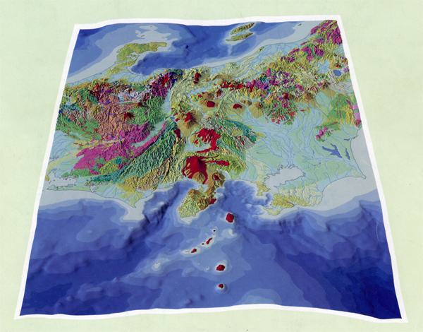
この図は、ユーラシアプレート、北米プレートフィリピン海プレート、更に太平洋プレートが、複雑に入り組む関東から中部にかけての地域の地質図をコンピュータによって立体的に表現したものである。
用いたデータは、数値地質図 (100万分の1日本地質図) の250mメッシュ地質データと国土地理院と海上保安庁水路部の水深情報ファイルで作成した250mメッシュ地形・推進データである。
この図の主要なパラメータは、地形の垂直強調 : 4倍、俯角 : 40度、画素数 : 横4,709×縦3,431である。
地質についての説明、日本列島の地質編集委員会編 「コンピュータグラフィックス 日本の地質」 (丸善) を参照されたい。
Table of Contents
| Title | Author | |
|---|---|---|
| A frontispiece | Research group of digital geological map, Osaka Bay Area (1-2) | 48-01_01.pdf(3,770KB) |
| Digital geological map of the Osaka Bay Area | Research group of digital geological map, Osaka Bay Area (3-4) | 48-01_02.pdf(225KB) |
| Digitization of the geological maps of the Osaka Bay Area | Jun-ichi MIYAZAKI (5-12) | 48-01_03.pdf(4,327KB) |
| Compilation of geological maps of the Osaka Bay Area | Hirohisa MATSUURA, Toshikazu YOSHIOKA, Yoshinori MIYACHI and Kiyohide MIZUNO (13-16) | 48-01_04.pdf(621KB) |
| Neotectonic map edited from the digital geological map of the Osaka Bay Area | Toshikazu YOSHIOKA, Eikichi TSUKUDA and Yasuaki MURATA (19-22) | 48-01_05.pdf(2,336KB) |
| Laser-heating 40Ar/39Ar dating system of the Geological Survey of Japan: System outlines and preliminary results | Kozo UTO, Osamu ISHIZUKA, Akikazu MATSUMOTO, Hikari KAMIOKA and Shigeko TOGASHI (23-46) | 48-01_06.pdf(8,854KB) |
| Abstracts for Geological Survey Seminar, No. 243 Poster session of the newest geological maps publised by GSJ(47-56) |
48-01_07.pdf(1,381KB) | |
| Abstracts for Geological Survey Seminar, No. 244 Geological buckground of the Hyogoken-Nanbu Earthquake(57-64) |
48-01_08.pdf(1,069KB) | |
| Recent outside publications | 48-01_09.pdf(324KB) | |