Subduction and Japan
Japan has been situated in the convergent plate boundary during long geohistorical ages. This means that the Japanese islands are built under the subduction tectonics.
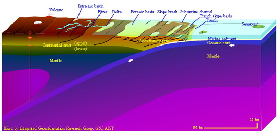
The oceanic plate consists of the oceanic crust and a part of the mantle beneath it. The oceanic crust brings basaltic lava, deep marine sediments, seamounts and so on. These are ripped into the continental crust together with the trench fill deposits at the subduction. This phenomenon is called "accretion", and ripped sediments and rocks formed by accretion are displayed as "accretionary complex" in geological map.

The deeper part of the accretionary complex is subjected to regional metamorphism. In addition, subducted oceanic plate brings water into the mantle and contributes to the generation of magma which forms large amounts of plutonic rocks and volcanic activities in and on the continental crust.
The Japanese islands are characterized as the grown-up continental margin formed by the subduction of the oceanic plate. Its geological features are as follows.
- Numbers of accretionary complexes accumulate in order and part of them are re-arranged by later tectonism.
- Age of the basement rocks is generally older in the continental side and younger in the ocean side.
- Volcanic and plutonic rocks of almost all ages are distributed in places reflecting the position and intensity of magmatic activity of that age.