Evidence of extraordinary tsunamis around the Hashigui-iwa dacite intrusion, south of the Kii Peninsula, Japan
-Based on the distribution of large boulders, tsunamis larger than that caused by the 1707 Hoei earthquake along the Nankai Trough have been inferred.
Summary of the AIST Press Release on September 12, 2022
>>Japanese
A research team consisting of NAMEGAYA Yuichi and his colleagues (Research Institute of Earthquake and Volcano Geology, Hosei University and Kankyo Chishitsu) revealed that past tsunamis, larger than that caused by the 1707 Hoei CE earthquake, hit around the Hashigui-iwa dacite (HID) intrusion at the south of the Kii Peninsula, Japan, facing the Nankai Trough (Fig. 1).
The HID intrusion is characterized by huge rocks in a straight line on the coast formed by magma intrusion in the Early Miocene and a well-developed wave-cut bench on the western side with many large boulders distributed on it. The identical lithology of the boulders and the HID intrusion makes it apparent that they were detached from the intrusion. If the boulders would have simply accumulated in the vicinity of the HID intrusion if they had merely fallen from it; however, they are distributed inland to the west. Therefore, the boulders are considered to have been delivered to their present locations by tsunamis or storm surges in the past.
The research team measured the locations and dimensions of the boulders in field surveys to determine if they were moved by tsunamis. Moreover, they calculated the tsunami inundations of the 1707 CE Hoei earthquake from published fault models (Aida et al., 1981a, 1981b; Annaka et al., 2003; Furumura et al., 2011). Fluid forces acting on the boulders from the simulated tsunamis were estimated and they were compared with the static frictional forces between the boulders and the ground. The boulders are determined to begin moving when the fluid forces exceed the static frictional forces. The modeling results indicate that some of the boulders could not have been moved even by the tsunami caused by the 1707 CE Hoei earthquake, which is the largest earthquake along the Nankai Trough in the historical era. This indicates that tsunamis larger than that hit around the HID intrusion. The details of this analysis have been published in Tectonophysics (DOI:10.1016/j.tecto.2022.229487).
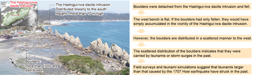
Fig. 1 Large boulders around the Hashigui-iwa dacite intrusion, south of Kii Peninsula, Japan.
The green area in the inlet is the largest-class earthquake source area as defined by the Headquarters for Earthquake Research Promotion (2013).
Aida, I. Numerical experiments of Historical Tsunamis Generated off the Coast of the Tokaido District. Bull. Earthq. Res. Inst., 56, pp. 367-390, 1981a.
Aida, I. Numerical experiments for the Tsunamis Generated off the Coast of the Nankaido District. Bull. Earthq. Res. Inst., 56, pp. 713-730, 1981b.
Annaka, T., Inagaki, K., Tanaka, H., Yanagisawa, K., Tsunami Suchi simulation ni motoduku Nankai trough zoi no ojishin no tokucho (Characteristics of great earthquakes along the Nankai trough based on numerical tsunami simulation). J. Earthq. Eng., 27, pp. 1-4, 2003.
http://library.jsce.or.jp/jsce/open/00578/2003/27-0307.pdf
Furumura, T., Imai, K., Maeda. T., A revised tsunami source model for the 1707 Hoei earthquake and simulation of tsunami inundation of Ryujin Lake, Kyushu, Japan. J. Geophys. Res., 116, 2011. 10.1029/2010JB007918.