Stress map of Japan available online - For assessment of future inland earthquakes and understanding of seismotectonics -
Summary of the AIST Press Release on June 14, 2022
>>Japanese
The Geological Survey of Japan (GSJ), AIST, published a stress map of inland Japan based on the focal mechanism solutions of more than 220,000 microearthquakes (magnitude (M) 0.5 – 3.5) at depths less than 20 km. The stress map is available online in the Crustal Stress Database of the GSJ.
The mesh interval of the stress map is 0.2 degrees of latitude and longitude, which is about 20 km, comparable to the typical length of an M 7 earthquake. The stress map shows interesting features at various scales, including the dominating east-west compression, areal trends, and local stress anomalies. In addition, we observed several cases in which the stress orientations are rotated around geological borders, such as faults and tectonic lines. The stress map facilitates assessment of future inland earthquakes and understanding of the seismotectonics of Japan.
In this study, we estimated the focal mechanism solutions from the P-wave first-motion polarities picked by a deep learning model. With the help of an automated process, we plan to expand the study area deeper and into the offshore area where ocean bottom seismic networks are available.
For details, see the work by Uchide et al. (2022) in the Journal of Geophysical Research Solid Earth. The digital data are available in an Open-File Report of GSJ.
This study used the seismic data from the Hi-net maintained by the National Research Institute for Earth Science and Disaster Resilience (NIED), the seismic network of the Japan Meteorological Agency (JMA), and the seismic network of GSJ. This study also used the Unified Earthquake Catalog of JMA.
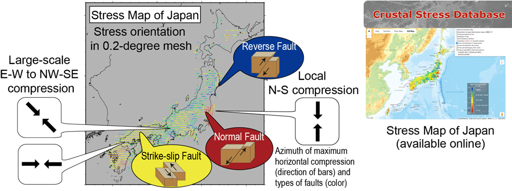
Fig. 1.Trends of the stress orientations in the stress map of Japan