Publication of the distribution maps of large-volume ignimbrites in Japan - geological data show the impact of large-scale eruptions
Summary of the AIST Press Release on January 25, 2022
>>Japanese
Points:
+ GSJ will publish a new series of “Distribution map of large-volume ignimbrite in Japan”.
+ The first publication of this series has been opened for public viewing.
+ The distribution map defines the area of the ignimbrite distribution, which provides fundamental information for disaster mitigation.
Outline:
Takarada Shinji, Geshi Nobuo, and their colleagues (Research Institute of Earthquake and Volcano Geology) have started to publish a series of maps that display the distributions of 12 large-scale ignimbrites, which were erupted during the late Pleistocene in Japan. The first publication is the distribution map of the Ito ignimbrite erupted from the Aira caldera in the southern part of Kyushu Island, Japan at around 30,000 years ago.
The series is issued based on compilations of geological field survey data and borehole data. The maps show the distribution and thickness of ignimbrites from 12 large-scale explosive eruptions. The first publication of this series is “Distribution Map of Ito Ignimbrite and associated deposits, Aira Caldera, Japan”. This map shows the present distribution of the ignimbrite, together with point data of the surface altitude and thickness, and the size and preferred orientation of pumice clasts. The reconstructed distribution of the ignimbrite based on numerical simulations is also provided in the explanation booklet. This reconstruction indicates that the original volume of the Ito ignimbrite was 800–900 km3, which is about 1.5 times larger than the previous estimate.
Large-scale explosive eruptions and the associated emplacement of ignimbrite deposits over wide areas have the potential to cause huge disasters, although such events are infrequent. The aim of the publication is to contribute to the mitigation of potential disasters in the future.
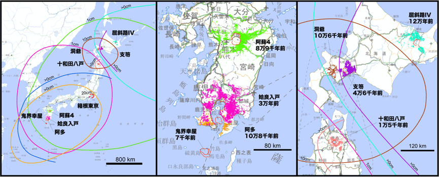
Distributions of the representative large-volume ignimbrites and associated co-ignimbrite ash
fall deposits within the last 120,000 years in Japan.
Background:
After the Tohoku earthquake in 2011, society has focused on geological events which can cause infrequent but serious disaster. Particularly, massive eruptions with large-scale pyroclastic flows can generate disastrous impacts not only in the vicinity of the volcano but also over a wide area. Geological records indicate that such massive eruptions have occurred in the past in Japan. The distributions of products ejected during massive eruptions provides valuable information about the impacts of future eruptions of similar scale. However, the distribution such as ash and pumice from a prehistoric large-scale eruption is not easy to recognize on currently available geological maps, because the geological record of massive eruptions has often been eroded and covered by younger sediments.
At AIST, the Geological Survey of Japan (GSJ) has published various geological datasets about the distribution and characteristics of volcanic deposits based on geological field surveys. Particularly, after the Tohoku earthquake, GSJ/AIST has conducted studies of massive eruptions in Japan and collected fundamental information about the eruption sequences, deposit distributions, and the impacted areas of large-scale explosive eruptions.
Contents of the research:
The series provides the information on the distribution and characteristics of volcanic deposits from large-scale explosive eruptions, based on the compiled results of geological field surveys carried out by GSJ/AIST.
“Distribution Map of Ito Ignimbrite and associated deposits, Aira Caldera, Japan,” contains a 1:250,000 scale map of the distribution of the Ito ignimbrite in the area within ~100 km from Kagoshima Bay (Fig. 1). In addition to the distribution on the ground surface, this map also shows its subsurface distribution based on borehole data. The map also shows point data of the distribution of the altitude and the thickness of the ignimbrite, the maximum size of pumice and lithic fragments in the ignimbrite, and the preferred orientation of the pumice fragments. The distribution of the Aira-Tn ash fall deposit, which is the co-ignimbrite ash of the Ito ignimbrite, is also shown (Figs. 2 and 3). The distribution reconstructed based on numerical simulation is also shown. It indicates that the original volume of the Ito ignimbrite was 800–900 km3, which is about 1.5 times larger than the previous estimate. The bulk volume of the Aira-Tn ash fall deposit is estimated as 300 km3. The distribution map contains an explanation booklet that provides the background geological information about the Aira caldera and the sequence of the Ito eruption, as well as the descriptions of the Ito ignimbrite and associated deposits. It provides a pictorial of representative field occurrences of the Ito ignimbrite and associated deposits. All contents can be downloaded from the website: https://www.gsj.jp/Map/EN/lvi.html.
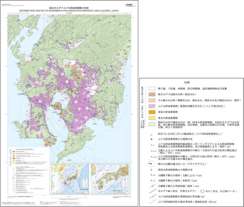
Fig. 1. Sample image of “Distribution Map of Ito Ignimbrite and associated deposits,
Aira Caldera, Japan”
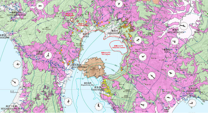
Fig. 2. Close-up image of the central part of “Distribution Map of Ito Ignimbrite and associated deposits, Aira Caldera, Japan”
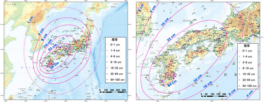
Fig. 3. Distribution of the Aira-Tn ash fall deposit associating with the Ito Ignimbrite.
Future plan:
GSJ plans to publish 12 distribution maps in total for the series. In 2022, the distribution map of the Shikotsu ignimbrite in Hokkaido will be published. In 2023, GSJ/AIST will publish the distribution map of the Aso 3 and 4 ignimbrites, which are the products of the largest explosive eruptions in Japan during the late Pleistocene.
Terms:
Large-scale eruption:
Eruptions which produce more than 10 cubic kilometers of pyroclastic materials. Large-scale eruptions often produce pyroclastic flow. Some of them result in caldera collapse.
Pyroclastic flow:
Pyroclastic flow is a fast-moving current of the mixture of hot gas, volcanic ash, and larger fragments, that flows along the ground away from a volcano. Its moving speed can reach 100 km/h. Areas covered by pyroclastic flows suffer catastrophic damage. A pyroclastic flow can be of various sizes; largest one can reach several tens of kilometers to more than 100 kilometers from the eruption site.
Ito Ignimbrite:
One of the largest-scale ignimbrites within the late Pleistocene – Holocene in Japan. Ito ignimbrite erupted from the Aira caldera in the northern part of the Kagoshima Bay (Kinko-wan Bay) at around 30,000 years ago. The non-welded ignimbrite deposits, called “Shirasu” in local name, form large ignimbrite plateaus in Kagoshima area.
Borehole core:
Cylinder-shaped rock samples of the materials drilled from underground. Borehole drilling is a major method for the investigation of underground geological units.
Caldera volcano:
A caldera is a large collapse structure that forms after the emptying of a magma chamber in a massive volcanic eruption. The volcanos with a collapse caldera repeat massive eruptions.
Aira-Tn ash fall deposit:
It is a deposit of glassy fine volcanic ash from the pyroclastic flow of the Ito Ignimbrite. Aira-Tn ash fall deposit covers over the Japanese islands. The Aira-Tn ash fall deposit is used as an important time indicator in geology and archeology.