3D Geological Map of Central Tokyo: Visualizing the detailed subsurface geology beneath the Tokyo Metropolis
Summary of the AIST Press Release on May 21, 2021
>>Japanese
The Geological Survey of Japan (GSJ), AIST has released the 3D geological map of central Tokyo, which can display the detailed subsurface geological structure up to the depth of several tens of meters.
Traditional 2D geologic maps cannot accurately represent the detailed geological structures beneath urbanized coastal plain areas. Nakazawa Tsutomu, Nonogaki Susumu and their colleagues (Research Institute of Geology and Geoinformation) have visualized the subsurface geological structure beneath central Tokyo with a vast amount of borehole data utilizing a specially developed computational geomodelling technique.
Beneath the Tokyo Lowland, Holocene soft muddy sediments fill the valley formed during the sea-level lowstand of the Last Glacial Maximum (ca. 20 ka). The computational analysis of the data revealed the detailed three-dimensional shape of the buried valley. On the other hand, similar valley-filling sediments are also found to be distributed beneath the Musashino Upland, which has been considered to be a hard ground. These valleys were formed during the glacial period around 140 ka, earlier than those beneath the Tokyo Lowland, and are filled with the soft muddy sediments of the last interglacial stage (ca. 130 to 120 ka). These valley-filling sediments have a potential risk of earthquake hazard and geotechnical problems in construction work. The information in the map is expected to contribute to geohazard risk reduction, city planning, infrastructure development, etc.
The 3D geological map is available on the website of the Urban Geological Map
(https://gbank.gsj.jp/urbangeol/index_en.html) for free.
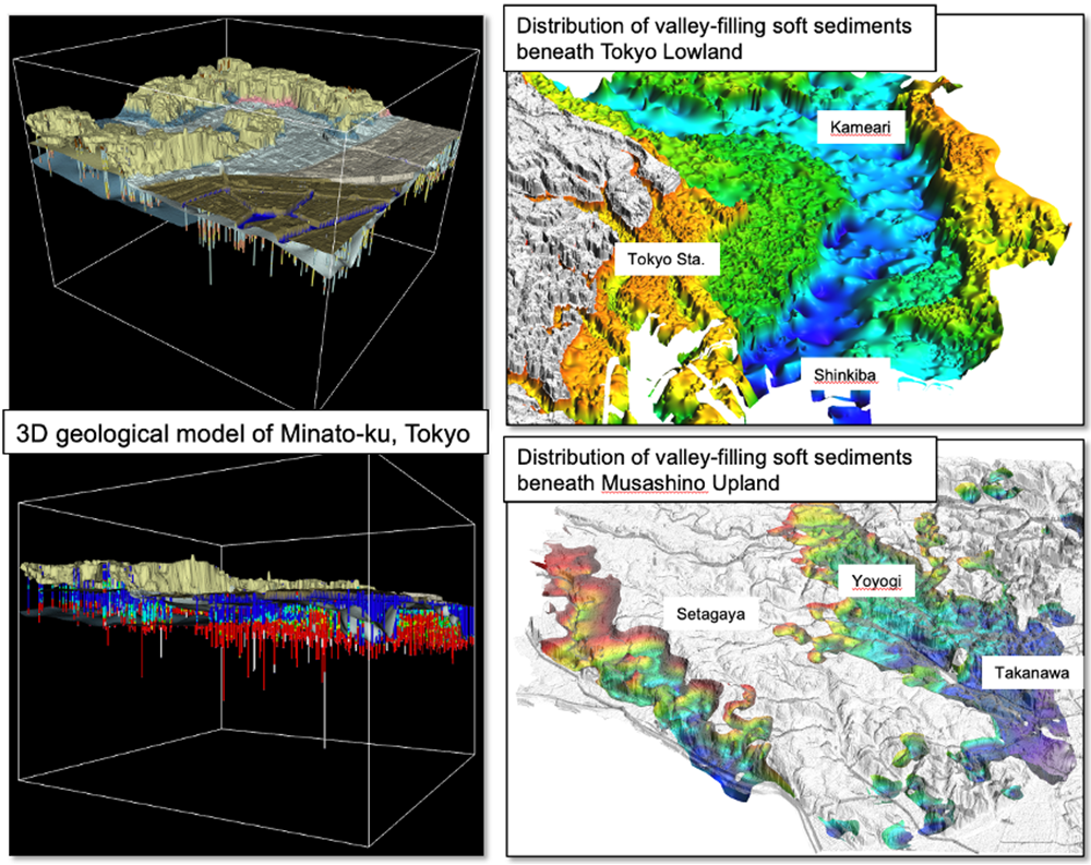
Fig. 1. 3D views of subsurface geology of central Tokyo