Publication of a detailed geological map showing the geological history of Lake Towada (Towada Ko)
–“Towada Ko”, 1:50,000 Quadrangle Geological Map of the Aomori-Akita prefectural border–
Summary of AIST Press Release Aug 20, 2019
>>Japanese
The Geological Survey of Japan (GSJ), AIST, has published the 1:50,000 Quadrangle Geological Map of “Towada Ko” (Lake Towada) on August 21, 2019 (Takashi Kudo, Takayuki Uchino and Satoshi Hamasaki, Research Institute of Geology and Geoinformation). The area is one of the important areas of geoscience that experienced a number of volcanic activities since the Japanese islands were formed.
Towada Ko, a caldera lake of 8.5 km in diameter formed by the volcanic activity of Towada volcano, is located on the border of Aomori and Akita Prefectures. The latest eruption of Towada volcano in AD915 is known as the largest one in Japan in the last 2,000 years.
The map was constructed after the original field survey combined with radiometric dating and petrological analyses conducted from 2013 to 2017. It is much more detailed map than the past ones published by local governments.
The geology of the Towada Ko District is roughly divided into the Mesozoic strata of about 170 Ma (million years ago) and the Cenozoic strata younger than 17 Ma. The former consists of accretionary complex and is sparsely distributed in the westernmost area. The latter mainly consists of various volcanic rocks of different ages and is widely distributed over the area. It is noteworthy that our geological survey has revealed the temporal and spatial change of the volcanic activity during the past 17 million years.
Towada Ko and Oirase Stream in the district are one of the famous tourist spots in the Tohoku area (northeeast Japan). Their landscape have been formed by the volcanic activity over 17 million years. The map is expected to be useful not only in the prediction and prevention of volcanic disasters, but also tourism, geoscientific education and the promotion of further understanding of the local geoscience.
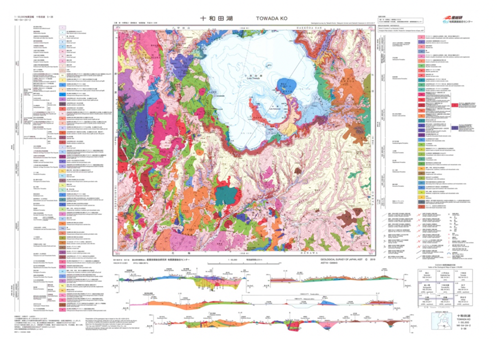
Fig. 1. 1:50,000 Quadrangle Geological Map of “Towada Ko”
The map is available from commission agents. For details, see the URL below.