Publication of geological map showing all components of a subduction zone
-“Motoyama”, 1:50,000 quadrangle geological map in the Shikoku Mountains -
Summary of AIST Press Release July 31, 2019
>>Japanese
The Geological Survey of Japan (GSJ) has published the 1:50,000 quadrangle geological map of “Motoyama”, constructed by Shunsuke Endo (Research Institute of Geology and Geoinformation, GSJ and Shimane University) and Shunji Yokoyama (Emeritus Professor of Kochi University).
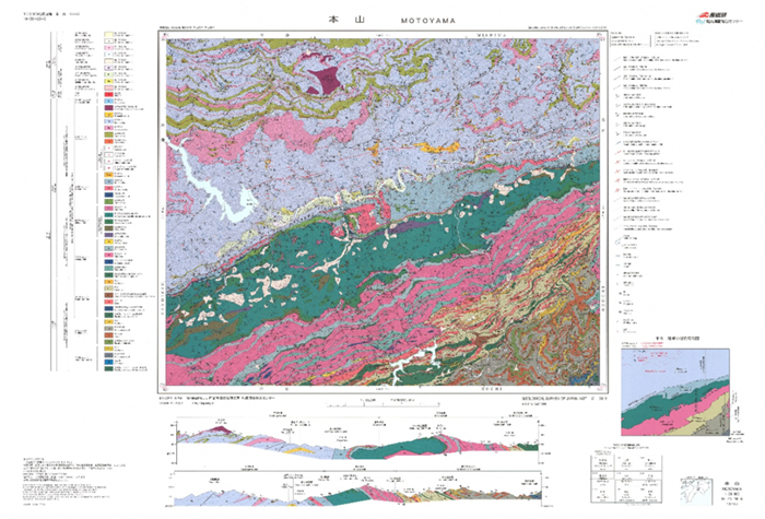
Fig. 1 1:50,000 geological map of “Motoyama”
The Motoyama district is located in the central part of the Shikoku Mountains composed of high-pressure metamorphic and accretionary complexes formed by the subduction of oceanic plates under the East Asian continental margin. The Asemi River is a worldwide-known geological route where high-pressure metamorphic rocks of the Sanbagawa belt are well exposed. Our geological survey reveals that the basement geology of the Motoyama district is composed of eight units formed at the depths of 10 to 60 km along the subduction plate boundary during the Early Jurassic to the Late Cretaceous. The geological conditions of the district, whose complicated geological structure represents almost all the components of a subduction zone, is quite unique in the world. The geological map can help users to learn the geological process in the deep subduction plate boundary. The map also shows the characteristics of geohazard, for example, the relationship between topographical/geological conditions and the landslides morphology at the Shirataki unit of the Sanbagawa belt and the Mikabu unit of the Mikabu belt. Such information is useful in civil engineering/construction and mitigation of natural disasters.
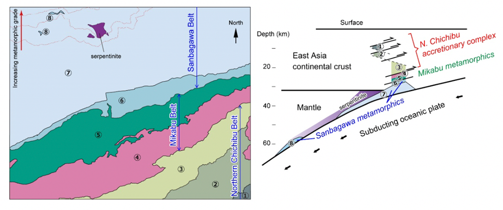
Fig. 2 Division of eight geological units in the Motoyama district (left).
Original configuration of the eight geological units in the Late Cretaceous subduction zone (right).
The map is available from commission agents. For details, see the URL below.