3D visualization of the subsurface geological structure beneath the northern area of Chiba Prefecture, central Japan
- Release of the first 3D geological map in Japan -
Summary of AIST Press Release on March 29, 2018
>>Japanese
The Geological Survey of Japan (GSJ), AIST has released the 3D geological map of the northern area of Chiba Prefecture, Kanto Plain, central Japan (Tsutomu Nakazawa, Susumu Nonogaki, et al., the Research Institute of Geology and Geoinformation). The 3D geological map is available on the website of the Urban Geological Map (https://gbank.gsj.jp/urbangeol/) for free.
Understanding the subsurface geology has recently become essential in dealing with soil liquefaction, geological pollution, and other issues. But traditional paper-based geological maps give little information on subsurface geological condition especially in urbanized coastal plains due to their flat topography. On the other hand, the 3D map can provide detailed one.
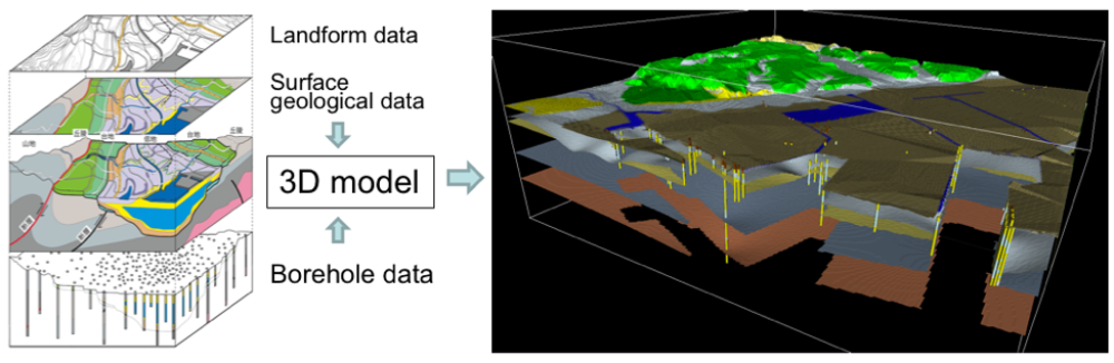
The map is created based on a virtual 3D geological model which is constructed by using surface and subsurface geological survey data collected by GSJ and borehole data accumulated by the prefectural government. Subsurface geological structure is displayed in 3D to a depth of several tens of meters and cross-section images are available along arbitrary lines.
It has revealed the detailed distribution of the Quaternary coastal and fluvial sediments and of artificial landfill soil in the area, which is useful for estimating earthquake shaking intensity and the possibility of liquefaction, as well as for understanding local groundwater flow. The information in the map is expected to contribute to geohazard risk reduction, city planning including infrastructure development, and investigation of geological pollution.
Data set of the 3D geological map and an example of a 3D view of subsurface geological structure beneath the Tokyo Bay area.