500-million-year history of the Japanese archipelago recorded in Kochi area
- 2nd edition of “Kochi”, 1:200,000 Geological Map -
Summary of the AIST Press Release on November 1, 2018
>>Japanese
The Geological Survey of Japan (GSJ) has published the 2nd edition of 1:200,000 Geological Map of "Kochi", revised for the first time in about 60 years by Hidetoshi Hara of the Research Institute of Geology and Geoinformation, et al.
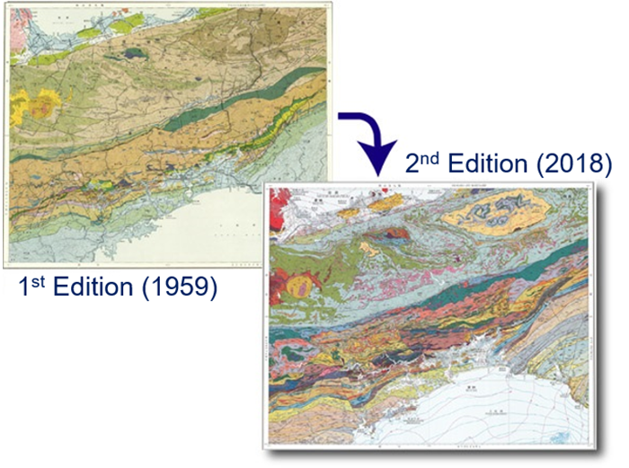
Fig. 1. 1st (upper left) and 2nd (lower right) edition of the 1:200,000 Geological Map of “Kochi”
Shikoku region, where the map area of “Kochi” is included, has a characteristic geology of such as accretionary complex and metamorphic rocks formed by subduction of an oceanic plate under a continental plate. In addition, geological strata of a wide range of ages from the Cambrian to the Quaternary are distributed in the map area. The area can represent the geology not only of the Shikoku region but also of the Japanese archipelago.
During the past 60 years from its first edition, geological research has significantly progressed particularly in elucidating the mechanism of the accretionary complex formation, metamorphism, and igneous process. The ages of strata have been determined by radiometric dating and the age of radiolarian fossils. The second edition is revised based on the latest geoscientific outcomes. The number of legends has considerably increased from 40 to 160. Other geological and geophysical information such as active faults, underground resources, and gravity anomaly is also included in the new edition.
The outcome is expected to be useful in the prediction of earthquake damage, disaster mitigation, tourism, and geoscientific education as well as in academic research.
The map is available from commission agents. For details, see the URL below.