Hunga Volcano, Tonga (2022)
Release date: February 4, 2022 (JST)
ASTER satellite images captured the eruption of the Hunga Volcano, Tonga, January 15, 2022
Topographic changes from 2000 to 2022 recorded in the ASTER database
The explosive eruption of the Hunga Volcano on January 15, 2022 caused significant sea-level changes even in Japan, 8000 km away from the volcano and reminded us of the far-reaching threats of volcanic eruptions.
The climactic eruption was one event in a series of processes that occurred at Hunga Volcano, which can be reconstructed by analyzing the images recorded in the ASTER database (Figure 1), in order to understand the eruption sequence.
Hunga Volcano
The volcano is an andesitic submarine volcano of the Tonga-Kermadec Arc, which has formed due to the subduction of the Pacific Plate under the Indo-Australian Plate. At the summit, there is a caldera with a diameter of four kilometers, on which the islands of Hunga Tonga and Hunga Haʻapai to the north, and the rock reefs to the south could be seen above sea level prior to the eruption in 2022 (Figure 2). The caldera was formed by multiple large-scale pyroclastic eruptions, the latest of which is known to have occurred around AD 1040 to 1180 (Brenna et al., 2022). Recent eruptions occurred on the southern rim in 1988, at Hunga Haʻapai on the north-eastern rim in 2009, and between Hunga Tonga and Hunga Haʻapai from 2014 to 2015 (Cronin et al., 2017).
The ASTER image on May 14, 2009 shows two pyroclastic cones with visible craters on Hunga Haʻapai (Figure 1), which had disappeared by May 1, 2010 due to erosion by waves. Eruptions from the 2014-15 crater were captured by images taken on January 7 and 14, 2015, and a large pyroclastic cone formed between the two islands during this period (Figure 1). The shape of the pyroclastic cone changed due to erosion, but it remained visible in the image of December 16, 2021, just before this eruption.
Volcanic activity history from 2021 to 2022
The current volcanism started near the 2014-15 crater from December 20, 2021 and continued to January 15, 2022, according to the Global Volcanism Program of the Smithsonian Institute National Museum of Natural History. It was a Surtseyan eruption, one of the types of phreatomagmatic eruptions, which is characterized by an explosive eruption plume. Starting at 4:20 AM on January 14, the first eruption was exceptionally violent: the plume reached the stratosphere at an altitude of 20km, and pyroclastic flows spread over the sea surface accompanied by small-scale tsunami. The subsequent eruption that started at 5:00 PM on January 15 was even larger, producing a plume that reached an altitude above 30 km and spread over 600 km in diameter covering all the territory of Tonga. No eruptions that have breached the sea surface have been observed since then.
The satellite images recorded on January 17 and 26 indicate that both Hunga Tonga and Hunga Haʻapai became much smaller, and the pyroclastic cone between them and the southern rock reefs have disappeared (Figure 1), which suggests a large-scale collapse of the summit of Hunga Volcano.
Features of the January 15, 2022 eruption
- the Volcanic Explosivity Index (VEI) is estimated to be 5 to 6, judging from the fact that the plume reached an altitude of 30 km. The scale of the eruption was larger than that of the Fukutoku-Okanoba eruption in August 2021, whose VEI is 4.
- judging from news footage, the pyroclastic fall deposits on Tongatapu island were mainly composed of polyhedral dark colored volcanic lapilli and no pumice was seen. Unlike the Fukutoku-Okanoba eruption, no floating pumice was observed either.
- the top of the submarine volcano is considered to have collapsed, judging from the post-eruption topographic change.
Implications from the viewpoint of disaster mitigation
Most large-scale eruptions with VEI greater than 5 are caused by Plinian eruptions characterized by the ejection of a large amount of pumice. However, this eruption was a gigantic phreatomagmatic or phreatic eruption which is considered to be caused by the reaction of magma and a large amount of seawater that was drawn into the volcanic vent after the collapse of the caldera.
Many volcanoes in Japan are basaltic to andesitic stratovolcanoes with summit calderas like Hunga Volcano. In 2000, a phreatomagmatic eruption occurred at Miyakejima Volcano after the collapse of the caldera (Geshi and Oikawa, 2008). The caldera-forming eruption at Izu-Oshima Volcano about 1700 years ago was a gigantic phreatic eruption similar in size to this event at Hunga Volcano (Yamamoto, 2006). The eruption of Hunga Volcano should now be recognized as one of the key scenarios to be considered in forecasting future eruptions at caldera volcanoes.
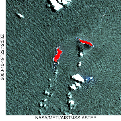
Figure 1: time-series imagery of the volcano (ASTER image data, available on the GSJ website*)
Coordinates: upper left (lat: 20.5, long: 175.45), lower right (lat:20.6, long:175.35)
Spatial resolution: 15 m, Color composition (R: Band 3N, G: Band2, Blue: Band1)
Shooting dates and times are shown at the left of the picture
* https://gbank.gsj.jp/madas/
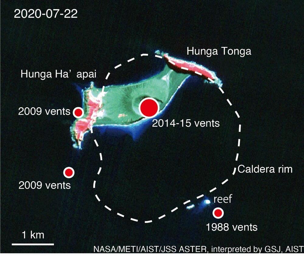
Figure 2: ASTER image taken on July 22, 2020. Red circles show the location of craters. The white dashed line is drawn after Cronin et al. (2017).
References
Brenna M, Cronin S J, Smith I E M,Pontesilli A, Tost M, Barker S, Tonga'onevai S, Kula T, Vaiomounga R, 2022. Post-caldera volcanism reveals shallow priming of an intra-ocean arc andesitic caldera: Hunga volcano, Tonga, SW Pacific. Lithos (in press 17 Jan 2022).
Cronin S J, Brenna M, Smith I E M, Barker S J, Tost M, Ford M, Tonga'onevai S, Kula T, Vaiomounga R, 2017. New volcanic island unveils explosive past. Eos, 98 (26 June 2017). doi:10.1029/2017EO076589
Geshi, N. and Oikawa T, 2008. Phreatomagmatic eruptions associated with the caldera collapse during the Miyakejima 2000 eruption, Japan. Journal of Volcanology and Geothermal Research, 176, 457-468.
Yamamoto T. 2006. Pyroclastic Density Current from the Caldera-forming Eruption of Izu-Oshima Volcano, Japan: Restudy of the Sashikiji, Member Based on Stratigraphy, Lithofacies, and Eruption Age. Bulletin of the Volcanological Society of Japan, 51, 257-271. (in Japanese with English abstract)
Related Information
METI AIST satellite Data Archive System: https://gbank.gsj.jp/madas/
IEVG(Research Institute of Earthquake and Volcano Geology)
IGG(Research Institute of Geology and Geoinformation)