Destructive earthquakes in southern Turkey(2023) top
Destructive earthquakes in southern Turkey on 6th February 2023 (Mw7.8 and Mw7.5)
The second report "Preliminary report on surface ruptures associated with Mw7.8 and Mw7.5 earthquakes in southern Turkey"
KONDO Hisao (Research Institute of Earthquake and Volcano Geology) and Selim Özalp (General Directorate of the Mineral Research and Exploration of Turkey (MTA))
We preliminarily report surface rupture distribution during the Mw 7.8 and Mw 7.5 earthquakes, based on air photo interpretation. The air photos were taken immediately after the occurrence of the earthquakes by General Directorate of Mapping in Turkey (HGM), and they are free to be used by the public (HGM website). GSJ/AIST and MTA have worked by international cooperative research on ‘Paleoseismological Study on the East Anatolian Fault System, Turkey’. We have carried out air photo interpretation and analysis in order to reveal surface rupture distribution during the respective large events. Because the northern area of the epicentral region is heavily covered with snow, it may be very hard to work in the field extensively until spring season. We have also measured offset amount at typical localities in photogrammetrically methods on the HGM website. The measurement error is estimated to be a few tens cm. This is preliminary report, therefore, the contents and description might be modified and updated later, based on further analysis and progress of the research.
The surface ruptures during both events extend mostly along the previously-mapped active faults (e.g., Emre et al., 2013). The northeastern termination of surface rupture associated with the Mw7.8 event is recognizable at least 5 km east of Çelikhan (Fig. 1). The southern termination is most likely located near Hatay and Antakya, but it is not fixed at this time due to massive liquefaction and heavily-damaged buildings etc. The eastern termination of surface rupture associated with the Mw 7.5 event can be followed at least around 50 km east of Çardak. The western termination has not been interpreted yet due to un-covered area of the air photo at this time.
The maximum offset during the Mw 7.8 event is measured nearly at the middle of the entire surface rupture. The number of offsets range between 7.5 m and 7.7 m (Fig. 2). Whereas, the maximum offset during the Mw 7.5 is measured between 8.7 m and 9.1 m (Fig. 3), that is curiously larger than those of the Mw 7.8 event. The amount of offset associated with these two large events is one of the largest offset ever produced by crustal strike-slip earthquakes in recent years. Extensive field mapping and measurement will reveal more detailed distribution and slip distribution associated with respective destructive earthquakes.
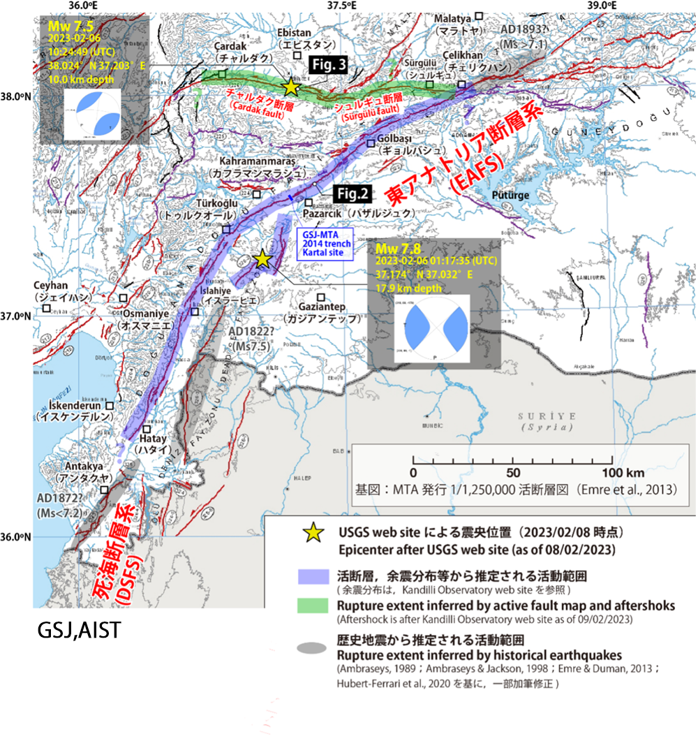
Fig. 1 The epicenter of two destructive earthquakes, mapped active faults, and the estimated rupture sections.The location of epicenter and focal mechanism is after USGS website as of 9th February in 2023.The base map of active fault distribution is after 1/1,250,000 active fault map produced by MTA (Emre et al., 2013).
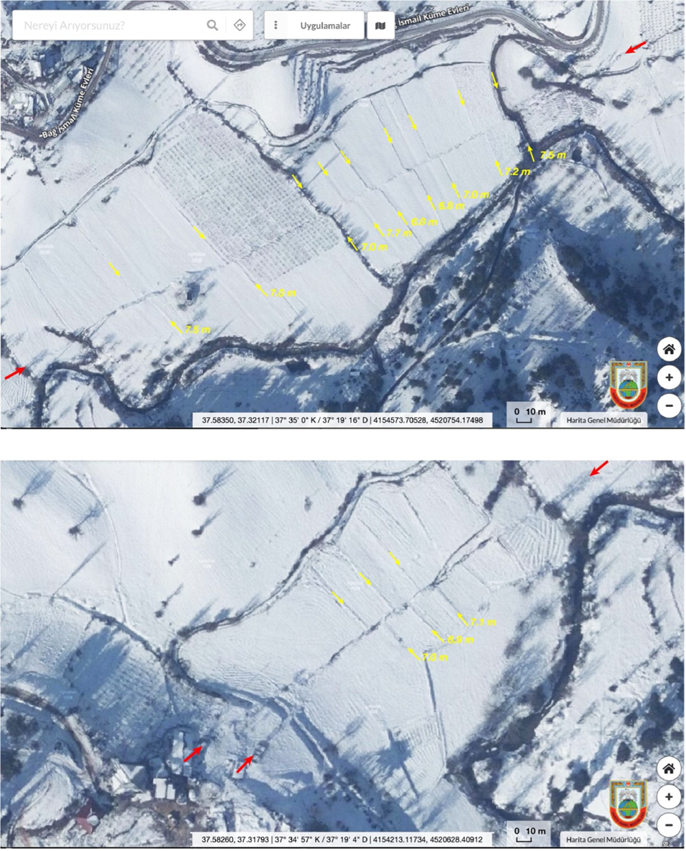
Fig. 2 The surface rupture and left-lateral offset features associated with the Mw 7.8 earthquake on 6th February 2023. The air photo is after HGM (General Directorate of Mapping in Turkey) website.
Red and yellow arrows indicate surface rupture and offset features (field boundary and channel), respectively.
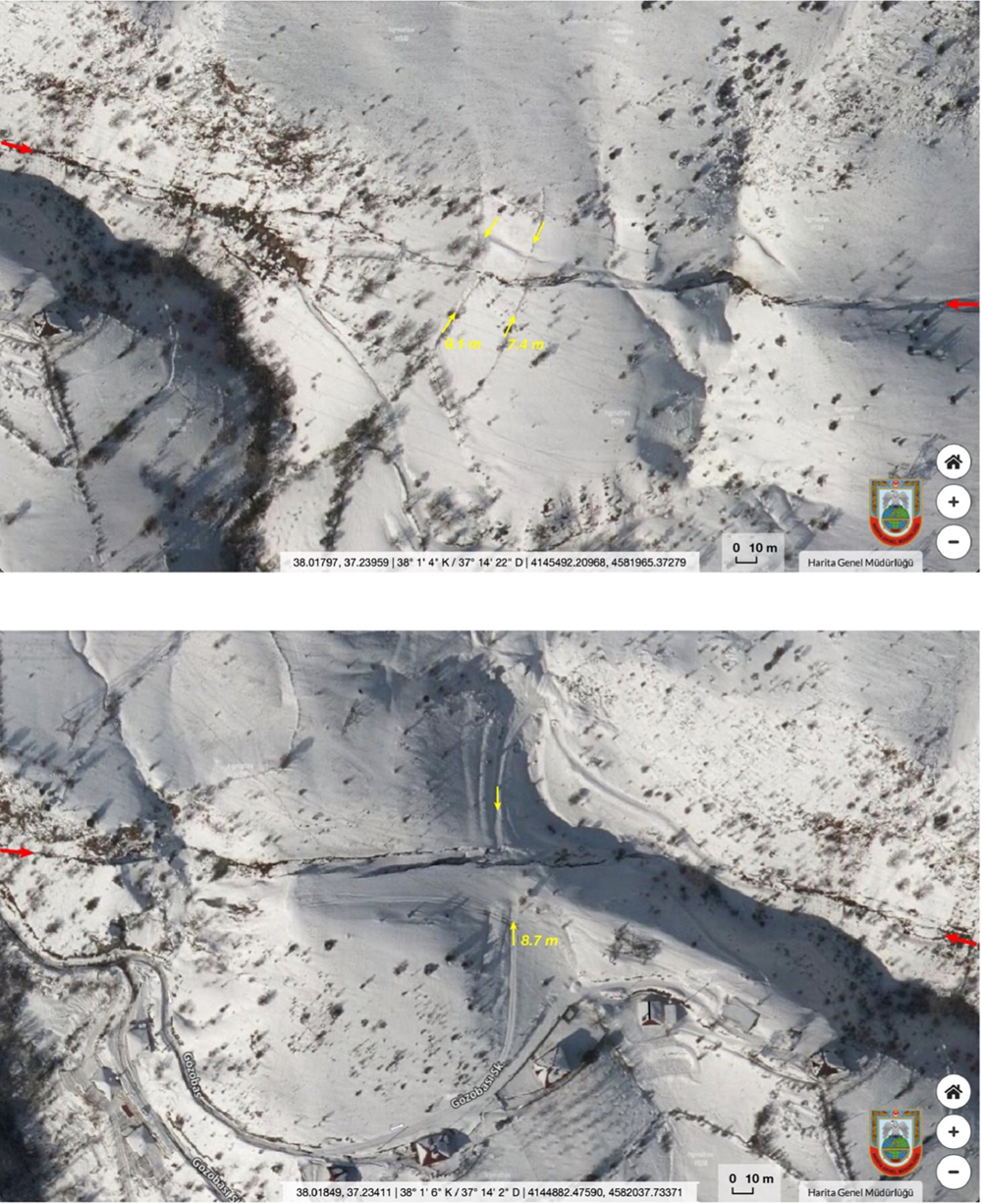
Fig. 3 The surface rupture and left-lateral offset features associated with the Mw 7.5 earthquake on 6th February 2023. The air photo is after HGM (General Directorate of Mapping in Turkey) website.
Red and yellow arrows indicate surface rupture and offset features (field boundary, tree line and road), respectively.
References
- Ambraseys, N.N. (1989) Temporary seismic quiescence: SE Turkey. Geophysical Journal International, 96 (2), p. 311–331.
- Duman, T.Y. and Emre, Ö. (2013) The East Anatolian Fault: geometry, segmentation and jog characteristics. Geological Society of London Special Publication, 372 (1), p. 495–529.
- Emre, Ö., Duman, T.Y., Özalp, S., Elmacı, H., Olgun, Ş. and Şaroğlu, F. (2013) Active Fault Map of Turkey with and Explanatory Text. General Directorate of Mineral Research and Exploration, Special Publication Series-30. Ankara-Turkey.
- HGM website, https://www.harita.gov.tr (Accessed: February 20, 2023)
- Hubert-Ferrari, A., Lamair, L., Hage, S., Schmidt, S., Çağatay, N. and Avşar, U. (2020) A 3800 yr paleoseismic record (Lake Hazar sediments, eastern Turkey): Implications for the East Anatolian Fault seismic cycle. Earth and Planetary Science Letters, 538, doi.org/10.1016/j.epsl.2020.116152
- USGS web site, https://www.usgs.gov/news/featured-story/m78-and-m75-kahramanmaras-earthquake-sequence-near-nurdagi-turkey-turkiye (Accessed: February 20, 2023)
Contact: Geological Survey of Japan, AIST