Scientific Approach to Marine Mineral and Fuel Resources
Last Updated: April 13, 2021
Geological Breakthroughs in Marine Mineral Resources
The pioneer of seabed resource exploration
In recent years, increased attention has been focused on mineral resources under the sea. However, an optimal method of finding seabed mineral resources has not yet been established. Targeting marine areas of resource potential including the extended continental shelf, our current surveys heavily focus on the areas around submarine volcanoes, where resources are considered most likely to be found. The survey results will be used to accumulate scientific information on the geological features of such localities, including knowledge of where resources can be found.
Comprehensive earth science research is essential for seabed resource exploration. Especially indispensable is elucidation of the formation process of submarine hydrothermal systems; this will provide important information needed to localize submarine deposits.
We are engaged in joint research with other institutions such as JOGMEC* and JAMSTEC**. The Geological Survey of Japan’s task is to narrow down and identify promising areas for seabed resource exploration based on its geological background. In other words, we are pioneering seabed resource exploration. Recently, in the area of the Higashi-Aogashima Caldera off the Aogashima Island of the Izu Islands, Tokyo, we discovered hydrothermal activity and chimneys with polymetallic massive sulfides.
Observing the seabed by using a wide range of acoustic wave
Key information about marine geology includes geological cross-sections of areas beneath the seabed, seabed-surface information including topography, gravity and magnetic data, and sediment information. Collecting and analyzing these data in an integrated way enables us to compile and manage marine geology information.
To obtain information on the geology on and under the seabed, we use acoustic waves with frequencies that differ according to the purpose. Lower frequency sources such as air guns (about 10 to 50 Hz) are used to investigate large-scale geological structures; higher frequency sources such as boomers (about 1 to 10 kHz) are used in high-resolution surveys of geological structure; and even higher frequency sources (more than 30 kHz) are used to obtain seabed-surface information. Multi-channel streamer (MCS) cables are used efficiently to obtain more detailed geological cross-sectional images, and multibeam echo sounders (MBESs) are used to obtain detailed information on submarine topography. The MBES, which can detect underwater acoustic anomalies in two dimensions, is useful for identifying promising seabed resource areas with outpourings of materials containing metals and other useful elements. Recently, introducing a deep towed system, we conduct the surveys to obtain higher resolution acoustic data. Equipped with a high-frequency (120 kHz and 410 kHz) side-scan sonar and a sub-bottom profiler of 3.5kHz, our system can obtain both submarine acoustic imaginary and geologic section.
The system has been further improved introducing a chemical sensor, an acoustic device developed with private enterprises, etc. As a deep towed survey unit which can get multiscale geoinformation at a time, it is actively utilized in marine resources exploration and other surveys.
Annotations:
* JOGMEC: Japan Oil, Gas and Metals National Corporation
** JAMSTEC: Japan Agency for Marine-Earth Science and Technology
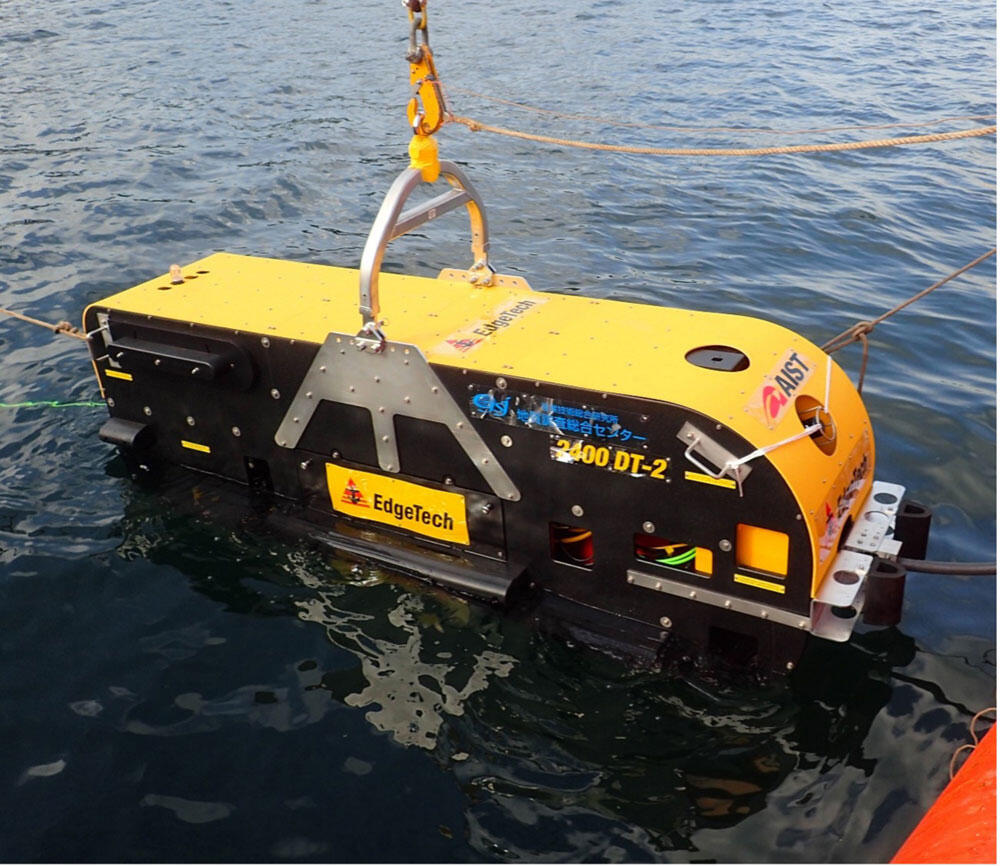
Deep-towed high-resolution survey package
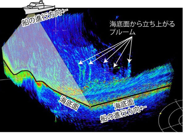
Results of a submarine topography survey using multibeam echo sounders (MBESs). This Figure shows seabed-surface information and the echo sound record around an area of submarine hydrothermal resources.
Japan has led research into methane hydrate and will continue to lead the world
Integrated research on “shallow-type methane hydrate”
Methane hydrate, which is expected to be the most promising future energy resource, is widely distributed in the sea around Japan. We had revealed this in 1990’s, and in the following national project launched in 2001, natural gas was successfully extracted from frozen methane hydrate layer beneath the seabed for the first time in the world in 2013 based on the repeated surveys in the Nankai Trough area of western Pacific Ocean. Japan has always led the world in the development of methane hydrate resources.
We are currently studying “shallow-type methane hydrate”, which is massive methane hydrate found at very shallow depths beneath the seabed in the Sea of Japan. Since 2013, we have conducted acoustic surveys, drillings and other surveys to obtain more accurate information on the distribution and quantity of methane hydrate. On the basis of research results obtained in these surveys, we have promoted a comprehensive research and development program, covering development of recovery and production technology for methane hydrate, clarification of detailed sub-seabed distribution of methane hydrate, monitoring in situ seabed environment, and evaluation of effects of methane hydrate production on submarine environments since 2019 in collaboration with other research units in AIST to contribute to exploiting shallow-type methane hydrate resources.
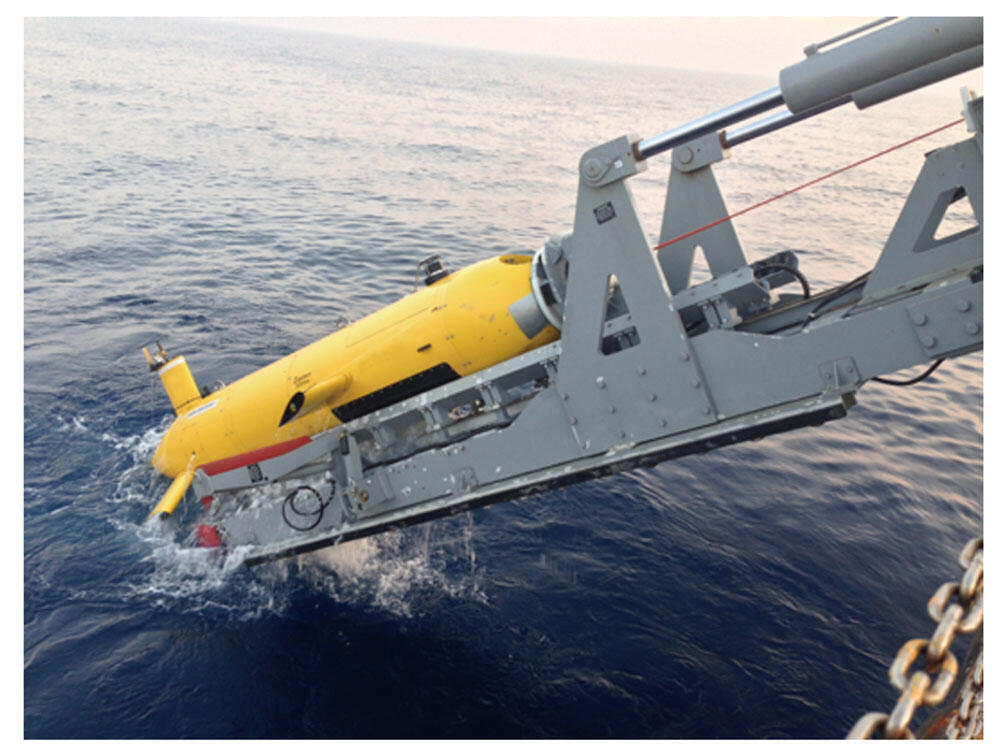
Precise submarine topographic and sub-bottom geologic structure survey using an autonomous underwater vehicle (AUV)
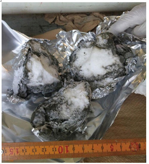
Massive methane hydrate recovered from seabed