Investigating Active Faults and Unconsolidated Sediments in Urban Coastal Area
Last Updated: April 13, 2021
Make Geo-Information Seamless from Sea to Land
Geological information on coastal areas
Large cities and infrastructure such as industrial districts and airports in Japan are situated mainly in coastal areas. It is easy to imagine that there could be enormous damage if a large earthquake were to occur there. However, there is not enough geological information on these coastal areas to prepare for the earthquake and mitigate possible damage.
In coastal areas, the complex topography formed by repeated marine transgressions and regressions is covered by thick unconsolidated sediments and seamless geological information linking sea and land is lacking. We integrate the geological/geophysical information between marine and land areas as well as study active faults, three-dimensional geological maps and the physical properties of soft sediments.
The search for hidden active faults
Recently, active faults separately identified in marine and land areas are found to be continuous in many places, and it has become highly important to understand their continuity as well as their activity to estimate the potential earthquake damage there. In our active-fault survey in coastal areas, we obtain accurate information using diversified survey methods, for example, acoustic exploration and sea-floor sediment survey in marine areas, seismic reflection survey, drilling exploration and outcrop exploration on land areas, and in both areas, gravity and aeromagnetic surveys.
We have published the outcomes of the survey of Boso Peninsula and the Sagami Bay area in Tokyo Metropolitan coastal areas and are currently preparing to publish the research results of Ise Bay and Mikawa Bay in the Chukyo Metropolitan. We will further conduct survey in the coastal area of Kii strait/channel, Kinki Metropolitan, and expand the area to the Seto Inland Sea. The surveys in these areas with dense population and industry have significant meaning because they are said to be vulnerable both to the Nankai Trough mega earthquakes and to ones caused by inland active faults. We will clarify the accurate distribution and activity potential of active faults, reveal unknown seismic history of the area, and improve the quality of geoinformation which is useful in national and local disaster mitigation planning.
Show Geoinformation on Underground Area in Three Dimensions
Understanding geology in 3D rather than in 2D
Traditional geological maps are printed on paper and two-dimensional (2D). It requires some expertise to understand the three-dimensional (3D) structure of subsurface strata from these maps. However, thanks to recent computing technology, it has become possible to create and deliver a new type of geological map, which can display subsurface information in 3D via the Internet. This helps intuitive understanding of the subsurface structure.
To create a 3D geological map of coastal areas, pilot drillings are carried out to determine the depositional age and environment, particle size, fossil components and to estimate seismic wave velocity. Along with these data, those from existing borehole logs obtained in public works are used to determine the subsurface geological structure in three dimensions to a depth of several tens of meters. Integrating the 3D geological models with other data such as vibration characteristics of underground structure, we promote the Internet delivery of the geological information that is useful for future urban planning and hazard mapping.
Distribution of unconsolidated sediments determines seismic damage
We have revealed the detailed topography of the subsurface incised-valleys formed during the Last Glacial Maximum and the distribution and geologic history of the soft alluvium in the Tokyo Lowland, integrating 20,000 borehole logs and drilling 18 stratotype sediment cores.
The result shows that the damaged area in the 1923 Great Kanto Earthquake closely coincides with the distribution of mud layer deposited 5,000 years ago; this mud is abundant in plant fragments and has an exceptionally high water content. The physical properties of the soft mud layer determined the scale of damage by the earthquake.
We are currently applying the similar approach to our research in other coastal areas of Tokyo Bay such as those in Kanagawa and Chiba prefectures. We plan to expand the investigation area to include other major coastal plains around the Japanese Islands in the near future.
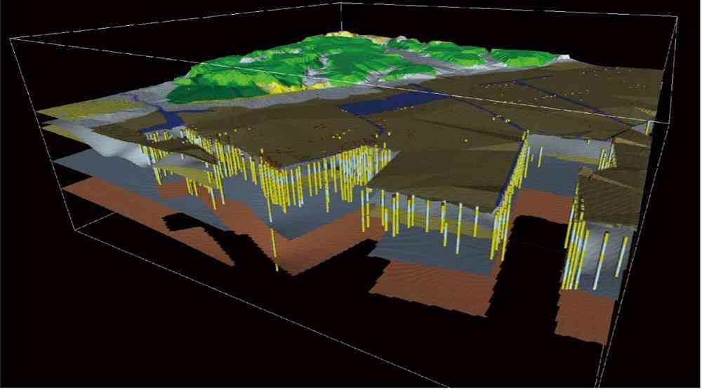
3D geological model of a coastal urban area.
3D visualization facilitates intuitive understanding of subsurface geology
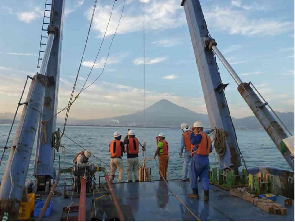
Piston-coring survey in Suruga Bay
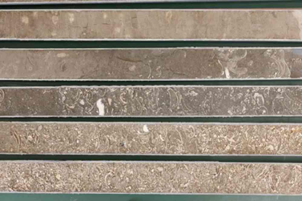
Sediment cores are cut in half and examined in detail (Photo by YASUTOMO Yasuhiro/GSJ)
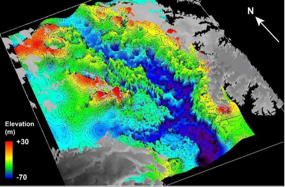
3D model of post-LGM incised valleys beneath the Tokyo Lowland

Microscopic observation of sediments obtained from the subsurface strata
(Photo by YASUTOMO Yasuhiro/GSJ)